Ebeye

Ebeye

Vorlage:Infobox Insel/Wartung/Höhe fehlt

Ebeye
Ebeye Island.jpg
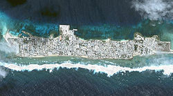
Gewässer Pazifischer Ozean
Inselgruppe Kwajalein-Atoll
Geographische Lage 8° 46′ 49″ N, 167° 44′ 14″ O8.780278167.737223Koordinaten: 8° 46′ 49″ N, 167° 44′ 14″ O
Ebeye (Marshallinseln)
Ebeye
Länge 2,1 km
Breite 390 m
Fläche 0,36 km²
Einwohner 9.345 (1999)
25.958 Einw./km²
Hauptort Ebeye

Ebeye ist die am stärksten bevölkerte Insel des Kwajalein-Atolls und des gesamten ozeanischen Staates der Marshallinseln. Auf einer Fläche von nur etwa 36 ha leben hier mehr als 9.300 Menschen (dies entspricht fast einem Fünftel der Gesamtbevölkerung des Landes), was sie zu einem der am dichtesten bevölkerten Orte auf der Erde macht. Sie ist gleichzeitig das wichtigste Zentrum der Ralik-Kette, die den östlichen Teil der Marshallinseln darstellt. Ein Teil der Bevölkerung sind Nachfahren der in Folge der amerikanischen Nukleartests im Jahre 1954 evakuierten Marshaller. Durch die Explosion der 15-Megatonnen-Bombe "Bravo" im Bikini-Atoll am 1. März des Jahres wurde der benachbarte Rongelap-Atoll durch radioaktiven Fallout völlig kontaminiert, sodass viele Bewohner schwer an Strahlenkrankheit erkrankten und Neugeborene oft schwere Missbildungen aufwiesen. Die US-Behörden siedelten die Betroffenen schließlich nach Ebeye um.

Ein Teil der Einwohner Ebeyes arbeiten heute im drei Meilen entfernten geheimen Raketen-Testgelände der US-Armee im Kwajalein-Atoll.[1]

Etwa ein Jahrzehnt lang war Ebeye deutsch; es gehörte ab 1906 zur Kolonie Deutsch-Neuguinea.

Literatur

  • Fritz W. Kramer: Bikini. Atomares Testgebiet im Pazifik. Wagenbach, 2000. – ISBN 3803123801

Weblinks

Einzelnachweise

  1. Ronald Reagan Ballistic Missile Defense Test Site

Wikimedia Foundation.

Игры ⚽ Нужна курсовая?

Schlagen Sie auch in anderen Wörterbüchern nach:

  • Ebeye — is the most populous island of Kwajalein Atoll in the Marshall Islands, as well as the center for Marshallese culture in the Ralik Chain of the archipelago. Settled on only 80 acres (360,000 m²) of land, it has a population of more than 12,000.… …   Wikipedia

  • Ebeye — 8°46′49″N 167°44′14″E / 8.78028, 167.73722 …   Wikipédia en Français

  • Kwajalein — (RMI). The southernmost and largest island in the atoll is named Kwajalein Island.The atoll lies in the Ralik Chain, 2,100 nautical miles (3900 km) southwest of Honolulu, Hawaii at coord|8|43|N|167|44|E|. Geography Kwajalein is one of the world s …   Wikipedia

  • Marshall Islands — Marshallese / sheuh leez , lees /, n., pl. ese, adj. n.pl. a group of 34 atolls in the W central Pacific: formerly a part of the Trust Territory of the Pacific Islands; since 1986 a self governing area associated with the U.S. 60,652; 70 sq. mi.… …   Universalium

  • Kwajalein — Vorlage:Infobox Insel/Wartung/Höhe fehlt Kwajalein NASA Bild von Kwajalein Gewässer Pazifischer Ozean Archipel …   Deutsch Wikipedia

  • Kwajalein-Atoll — Kwajalein NASA Bild von Kwajalein Gewässer Pazifischer Ozean Archipel Anza …   Deutsch Wikipedia

  • MH-KWA — Kwajalein NASA Bild von Kwajalein Gewässer Pazifischer Ozean Archipel Anza …   Deutsch Wikipedia

  • Marshall Islands — <p></p> <p></p> Introduction ::Marshall Islands <p></p> Background: <p></p> After almost four decades under US administration as the easternmost part of the UN Trust Territory of the Pacific Islands …   The World Factbook

  • Communications in the Marshall Islands — This article is about communications systems in the Marshall Islands. In 2010, the Majuro and Kwajalein Atoll were connected to the Internet using the HANTRU 1 undersea cable to provide high speed bandwidth. Faster Internet service was rolled out …   Wikipedia

  • Economy of the Marshall Islands — The government of the Marshall Islands is the largest employer, employing 30.6% of the work force, down by 3.4% since 1988. GDP is derived mainly from payments made by the United States under the terms of the Compact of Free Association. Direct U …   Wikipedia

Share the article and excerpts

Direct link
Do a right-click on the link above
and select “Copy Link”