- East Northamptonshire
-
East Northamptonshire District 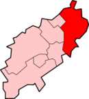
Lage in NorthamptonshireStatus District Region East Midlands Verw.grafschaft Northamptonshire Verwaltungssitz Thrapston Fläche 509,79 km² (99.) Einwohner 85.400 (280.) ONS-Code 34UD Website east-northamptonshire.gov.uk East Northamptonshire ist ein District in der Grafschaft Northamptonshire in England. Verwaltungssitz ist die Stadt Thrapston. Weitere bedeutende Orte sind Higham Ferrers, Irthlingborough, Oundle, Raunds und Rushden.
Der Bezirk wurde am 1. April 1974 gebildet und entstand aus der Fusion des Municipal Borough Higham Ferrers, der Urban Districts Irthlingborough, Oundle, Raunds und Rushden, des Rural District Oundle and Thrapston sowie eines Teils des Rural District Wellingborough.
Corby | Daventry | East Northamptonshire | Kettering | Northampton | South Northamptonshire | Wellingborough
Wikimedia Foundation.
Schlagen Sie auch in anderen Wörterbüchern nach:
East Northamptonshire — For the former parliamentary constituency, see East Northamptonshire (UK Parliament constituency). East Northamptonshire District Non metropolitan district … Wikipedia
East Northamptonshire (UK Parliament constituency) — East Northamptonshire Former County constituency for the House of Commons 1885 (1885)–1918 (1918) … Wikipedia
East Northamptonshire — ▪ district, England, United Kingdom district, administrative and historic county of Northamptonshire, south central England, in the northeastern part of the county. The district is rural and agricultural in character except in the extreme… … Universalium
Ashton, East Northamptonshire — infobox UK place country = England static static image caption= latitude= 52.13 longitude= 00.89 official name =Ashton population = shire district= shire county= Northamptonshire metropolitan borough= metropolitan county = region=East Midlands… … Wikipedia
Northamptonshire — Geografie Status: Zeremonielle und Verwaltungsgrafschaft Region: East Midlands Fläche: 2.364 km² Verwa … Deutsch Wikipedia
Northamptonshire — Coordinates: 52°17′N 0°50′W / 52.283°N 0.833°W / 52.283; 0.833 … Wikipedia
Northamptonshire Council election, 2009 — Elections to Northamptonshire County Council took place on 4 June 2009, having been delayed from 7 May, in order to coincide with elections to the European Parliament. Contents 1 Results 2 Division by Division Results, by District 2.1 Corby… … Wikipedia
Northamptonshire — /nawr thamp teuhn shear , sheuhr, nawrth hamp /, n. a county in central England. 500,100; 914 sq. mi. (2365 sq. km). Also called Northampton. * * * Administrative (pop., 2001: 629,676) and historic county of the East Midlands region, England. It… … Universalium
Northamptonshire — 52°17′N 0°50′W / 52.283, 0.833 … Wikipédia en Français
Northamptonshire County Football Association — Northamptonshire County FA logo Purpose/focus Football association Location Moulton Park, Northampton Coordinates … Wikipedia
East Northamptonshire

18+
© Academic, 2000-2024
- Kontaktieren Sie uns: Unterstützung, Werbung
Wörterbücher Export, schritte mit PHP, Joomla, Drupal, WordPress, MODx.