- Earth Observing System
-
Das Earth Observing System (englisch für Erdbeobachtungssystem), kurz EOS, ist ein Forschungsprogramm der NASA, zu dem eine Reihe künstlicher Satelliten mit wissenschaftlichen Instrumenten im Erdorbit gehören. Diese Erdbeobachtungssatelliten ermöglichen langfristige Erkundungen der Landoberfläche, der Biosphäre, der Atmosphäre und der Ozeane. Das Programm wurde 1997 gestartet und ist Teil des NASA-Projekts Earth Science Enterprise.
Liste der Missionen und deren Startdaten
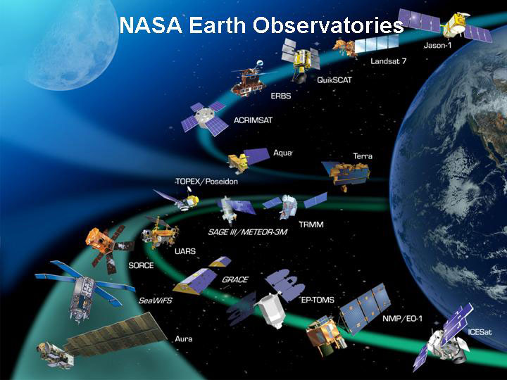
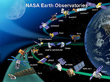 Die Satelliten-Flotte der NASA für die Erdbeobachtung
- SeaWiFS – 1. August 1997 (Sea-viewing Wide Field-of-view Sensor)
- TRMM – 27. November 1997 (Tropical Rainfall Measuring Mission)
- Landsat 7 – 15. April 1999
- QuikSCAT – 19. Juni 1999 (Quick Scatterometer)
- Terra - 18. Dezember 1999
- ACRIMSat – 20. Dezember 1999 (Active Cavity Radiometer Irradiance Monitors)
- NMP/EO-1 – 21. November 2000 (New Millennium Program/Earth Observing-1)
- Jason-1 – 7. Dezember 2001
- Sage III/ METEOR 3M – 10. Dezember 2001 (Stratospheric Aerosol and Gas Experiment)
- GRACE – 17. März 2002 (Gravity Recovery and Climate Experiment)
- Aqua – 4. Mai 2002
- ADEOS II/Midori II – 12. Dezember 2002 (Advanced Earth Observing Satellit)
- ICESat – 12. Januar 2003 (Ice, Cloud and Land Elevation Satellite)
- SORCE – 25. Januar 2003 (Solar Radiation and Climate Experiment )
- Aura – 15. Juli 2004
- CloudSat – 28. April 2006
- CALIPSO – 28. April 2006 (Cloud-Aerosol Lidar and Infrared Pathfinder Satellite Observations)
- OSTM (Jason–2) – 20. Juni 2008 (Ocean Surface Topography Mission)
- OCO – 24. Februar 2009, Absturz ins Meer, nach Fehler bei Abtrennung der Nutzlastverkleidung (Orbiting Carbon Observatory)
- Glory - 4. März 2011, Absturz ins Meer, nach Fehler bei Abtrennung der Nutzlastverkleidung
- Aquarius – 2010
- NPP – September 2011 (National Polar-orbiting Operational Environmental Satellite System Preparatory Project)
- GPM (Satellit) - 2013 (Global Precipitation Measurement)
- LDCM - 2011 (Landsat Data Continuity Mission)
Siehe auch
-
 Commons: Earth Observing System program – Sammlung von Bildern, Videos und Audiodateien
 - Earth Explorer Missions für das entsprechende ESA−Programm
- Liste der Erdbeobachtungssatelliten
- Umweltsatellit, Wettersatellit, Satellitenmeteorologie
Weblinks
- http://eospso.gsfc.nasa.gov/ – Homepage des Earth Observing Systems (englisch)
- http://www.earth.nasa.gov/ – Homepage von Earth Science Enterprise (englisch)
- Homepage NASA Earth Observatory (englisch)
 Zum Forschungsprogramm Earth Observing System (EOS) der NASA gehörende Missionen
SeaWiFS · TRMM · Landsat 7 · QuikSCAT · Terra · ACRIMSat · NMP/EO-1 · Jason-1 · Sage III · GRACE · Aqua · ADEOS-II/Midori-II · ICESat · SORCE · Aura · CloudSat · CALIPSO · OCO · Glory · OSTM · Aquarius · NPOESS Preparatory Project · ESSP · NMP/EO-3
Wikimedia Foundation.
Schlagen Sie auch in anderen Wörterbüchern nach:
Earth Observing System — (EOS) est un programme de l agence spatiale américaine de la NASA qui regroupe un ensemble de satellites chargés de collecter des données sur de longues périodes sur la surface de la Terre, la biosphère, l atmosphère terrestre et les océans de la … Wikipédia en Français
Earth Observing System — The Earth Observing System (EOS) is a program of NASA comprising a series of artificial satellite missions and scientific instruments in Earth orbit designed for long term global observations of the land surface, biosphere, atmosphere, and oceans … Wikipedia
Global Earth Observing System of Systems — Global Earth Observation System of Systems (GEOSS) ist eine Initiative der ad hoc intergovernmental Group on Earth Observations (ad hoc GEO), um bei der Erdbeobachtung enger miteinander zu kooperieren. Das Programm wurde 2005 in Brüssel von etwa… … Deutsch Wikipedia
Earth Observing-1 — EO 1 Earth Observing 1 Mission (EO 1) est un satellite de télédétection faisant partie du programme New Millenium de la NASA. Il est destiné à valider de nouvelles technologies utilisées pour les instruments scientifiques embarqués et la plate… … Wikipédia en Français
Constellation Observing System for Meteorology, Ionosphere, and Climate — COSMIC Operator COSMIC Major contractors Orbital Sciences Corporation Mission type Meteorology, Ionosphere, Climatology, and … Wikipedia
Integrated Ocean Observing System — The Integrated Ocean Observing System ( [http://www.ocean.us IOOS] ) is an organization of systems that routinely and continuously provides quality controlled data and information on current and future states of the oceans and Great Lakes from… … Wikipedia
Global Earth Observation System of Systems — (GEOSS) ist eine Initiative der ad hoc intergovernmental Group on Earth Observations (ad hoc GEO), um bei der Erdbeobachtung enger miteinander zu kooperieren. Das Programm wurde 2005 in Brüssel von etwa 40 Staaten beschlossen und hat eine… … Deutsch Wikipedia
Global Earth Observation System of Systems — GEOSS redirects here. GEOSS may also refer to the Geometric Centre of the Republic of Slovenia. The Global Earth Observation System of Systems (GEOSS) is being built by the Group on Earth Observations (GEO) on the basis of a 10 Year… … Wikipedia
NOAA Observing System Architecture — The NOAA Observing System Architecture (NOSA) is a collection of over 100 of NOAA s environmental datasets. NOSA was established to develop an observational architecture that helps NOAA: design observing systems that support NOAA s mission and… … Wikipedia
Earth observation satellite — An Earth observation satellite, ERS 2 Earth observation satellites are satellites specifically designed to observe Earth from orbit, similar to reconnaissance satellites but intended for non military uses such as environmental monitoring,… … Wikipedia
Earth Observing System
18+
© Academic, 2000-2024
- Kontaktieren Sie uns: Unterstützung, Werbung
Wörterbücher Export, schritte mit PHP, Joomla, Drupal, WordPress, MODx.