- Derwentside
-
Derwentside District 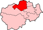
Lage in DurhamStatus District Region North East England Verw.grafschaft Durham Verwaltungssitz Consett Fläche 270,79 km² (168.) Einwohner 85.074 (273.) Stand 2001 ONS-Code 20UD Website - Gründung 1974 Auflösung 2009 Derwentside war ein District in der Grafschaft Durham in England, der nach dem Fluss Derwent benannt ist. Verwaltungssitz war die Stadt Consett. Weitere bedeutende Orte des ehemaligen Districts waren Lanchester und Stanley. Es bestand eine Städtepartnerschaft mit Werdohl in Deutschland.
Der Bezirk wurde am 1. April 1974 gebildet und entstand aus der Fusion der Urban Districts Consett und Stanley sowie des Rural District Lanchester. Am 1. April 2009 wurden neben Derwentside alle Dictricts im County Durham abgeschafft und zur Unitary Authority Durham zusammengefasst.
Kategorien:- Ehemaliger District (North East England)
- County Durham

Wikimedia Foundation.