- Datu Paglas
-
Municipality of Datu Paglas Lage von Datu Paglas in der Provinz Maguindanao 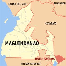
Basisdaten Bezirk: Autonomous Region in Muslim Mindanao Provinz: Maguindanao Barangays: 23 Distrikt: 2. Distrikt von Maguindanao PSGC: 153805000 Einkommensklasse: unbekannt (1-6) Haushalte: 3673 Zensus 1. Mai 2000Einwohnerzahl: 29.979 Zensus 1. August 2007Koordinaten: 6° 46′ N, 124° 51′ O6.7666666666667124.85Koordinaten: 6° 46′ N, 124° 51′ O Postleitzahl: 9617 Offizielle Webpräsenz: www.datupaglas.gov.ph Geographische Lage auf den Philippinen 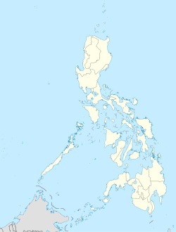

Datu Paglas Datu Paglas ist eine philippinische Stadtgemeinde in der Provinz Maguindanao. Nach dem Zensus vom 1. Mai 2000 hat sie 20.014 Einwohner in 3673 Haushalten.
Baranggays
Datu Paglas ist politisch in 23 Baranggays unterteilt.
- Alip (Pob.)
- Damawato
- Katil
- Malala
- Mangadeg
- Manindolo
- Puya
- Sepaka
- Lomoyon
- Kalumenga (Kalumanga)
- Palao sa Buto
- Damalusay
- Bonawan
- Bulod
- Datang
- Elbebe
- Lipao
- Madidis
- Makat
- Mao
- Napok
- Poblacion
- Salendab
Städte und Stadtgemeinden in der Provinz MaguindanaoStädte: Cotabato City
Stadtgemeinden: Ampatuan | Buluan | Datu Abdullah Sangki | Datu Anggal Midtimbang | Datu Paglas | Datu Piang | Datu Saudi-Ampatuan | Datu Unsay | Gen. S. K. Pendatun | Guindulungan | Mamasapano | Mangudadatu | Pagagawan | Pagalungan | Paglat | Pandag | Rajah Buayan | Shariff Aguak | South Upi | Sultan sa Barongis | Talayan | Talitay
Wikimedia Foundation.
Schlagen Sie auch in anderen Wörterbüchern nach:
Datu Paglas — Saltar a navegación, búsqueda Datu Paglas es un municipio filipino de la provincia de Maguindanao. Según el censo de 2000, tiene 20 014 habitantes en 3673 casas. Barangayes Datu Paglas se divide políticamente a 23 barangayes. Alip (Pob.) Damawato … Wikipedia Español
Datu Paglas — Original name in latin Datu Paglas Name in other language Datu Paglas State code PH Continent/City Asia/Manila longitude 6.76667 latitude 124.85 altitude 22 Population 3851 Date 2011 07 31 … Cities with a population over 1000 database
Datu Paglas, Maguindanao — Map of Maguindanao showing the location of Datu Paglas Coordinates … Wikipedia
Datu Piang, Maguindanao — Datu Piang Seal … Wikipedia
Datu Saudi-Ampatuan, Maguindanao — Datu Saudi biruar Ampatuan, Maguindanao Map of Maguindanao showing the location of Datu Saudi Ampatuan Country Philippines … Wikipedia
Datu Unsay, Maguindanao — Map of Maguindanao showing the location of Datu Unsay Country Philippines Region … Wikipedia
Datu Abdullah Sangki, Maguindanao — Map of Maguindanao showing the location of Datu Abdullah Sangki Country Philippines … Wikipedia
Datu Anggal Midtimbang, Maguindanao — Country Philippines Region Autonomous Region in Muslim Mindanao Province Maguindanao Districts Lone district of Maguindanao … Wikipedia
Datu Salibo, Maguindanao — Datu Salibo is a municipality in the province of Maguindanao, Philippines. According to the 2007 census, it has a population of at least 13,876 people (not counting the population of barangays only partially included). It was created out of 4… … Wikipedia
Datu Hoffer Ampatuan, Maguindanao — Datu Hoffer Ampatuan is a municipality in the province of Maguindanao, Philippines. According to the 2007 census, it has a population of at least 22,471 people (not counting the population of barangays only partially included). It was created out … Wikipedia
Datu Paglas


18+
© Academic, 2000-2024
- Kontaktieren Sie uns: Unterstützung, Werbung
Wörterbücher Export, schritte mit PHP, Joomla, Drupal, WordPress, MODx.