- Adair County (Iowa)
-
Verwaltung US-Bundesstaat: Iowa Verwaltungssitz: Greenfield Adresse des
Verwaltungssitzes:County Courthouse
400 Public Square
Greenfield, IA 50849-1259Gründung: 15. Januar 1851 Gebildet aus: Pottawattamie County Vorwahl: 001 641 Demographie Einwohner: 7682 (2010) Bevölkerungsdichte: 5,2 Einwohner/km² Geographie Fläche gesamt: 1.477 km² Wasserfläche: 3 km² Karte 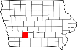
Website: www.adaircountyiowa.org Das Adair County[1] ist ein County im US-amerikanischen Bundesstaat Iowa. Bei der Volkszählung im Jahr 2010 hatte das County 7.682 Einwohner und eine Bevölkerungsdichte von 5,2 Einwohnern pro Quadratkilometer. Der Verwaltungssitz (County Seat) ist Greenfield.[2]
Inhaltsverzeichnis
Geografie
Das County liegt im mittleren Südwesten von Iowa und hat eine Fläche von 1.477 Quadratkilometern, wovon 3 Quadratkilometer Wasserfläche sind. Es grenzt an folgende Countys:
Audubon County Guthrie County Cass County 
Madison County Adams County Union County Geschichte
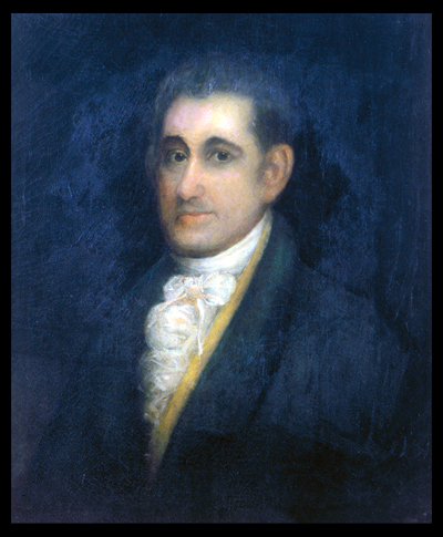
 J. Adair
Das Adair County wurde am 15. Januar 1851 aus Teilen des Pottawattamie County gebildet. Benannt wurde es nach John Adair (1757-1840), einem Helden im Krieg von 1812 und achten Gouverneur von Kentucky (1820-1824).
Demografische Daten
Historische Einwohnerzahlen Census Einwohner ± in % 1860 984 — 1870 3982 300 % 1880 11.667 200 % 1890 14.534 20 % 1900 16.192 10 % 1910 14.420 -10 % 1920 14.259 -1 % 1930 13.891 -3 % 1940 13.196 -5 % 1950 12.292 -7 % 1960 10.893 -10 % 1970 9487 -10 % 1980 9509 0,2 % 1990 8409 -10 % 2000 8243 -2 % 2010 7682 -7 % Vor 1900[3] 1900–1990[4], 2010[5] Nach der Volkszählung im Jahr 2010 lebten im Adair County 7.682 Menschen in 3.347 Haushalten. Die Bevölkerungsdichte betrug 5,2 Einwohner pro Quadratkilometer.
Ethnisch betrachtet setzte sich die Bevölkerung zusammen aus 98,4 Prozent Weißen, 0,1 Prozent Afroamerikanern, 0,1 Prozent amerikanischen Ureinwohnern, 0,3 Prozent Asiaten sowie aus anderen ethnischen Gruppen; 0,7 Prozent stammten von zwei oder mehr Ethnien ab. Unabhängig von der ethnischen Zugehörigkeit waren 1,3 Prozent der Bevölkerung spanischer oder lateinamerikanischer Abstammung.
In den 3.347 Haushalten lebten statistisch je 2,26 Personen.
20,9 Prozent der Bevölkerung waren unter 18 Jahre alt, 56,8 Prozent waren zwischen 18 und 64 und 22,3 Prozent waren 65 Jahre oder älter. 51,1 Prozent der Bevölkerung war weiblich.
Das jährliche Durchschnittseinkommen eines Haushalts lag bei 47.553 USD. Das Pro - Kopf - Einkommen betrug 22.897 USD. 10,7 Prozent der Einwohner lebten unterhalb der Armutsgrenze.[6]
Städte und Gemeinden
- Adair1
- Bridgewater
- Casey1
- Fontanelle
- Greenfield
- Orient
- Stuart1
- Arbor Hill
1 - teilweise im Guthrie County
Einzelnachweise
- ↑ GNIS-ID: 465190. Abgerufen am 23. Februar 2011 (englisch).
- ↑ National Association of Counties Abgerufen am 9. Oktober 2011
- ↑ U.S. Census Bureau - Census of Population and Housing Abgerufen am 15. März 2011
- ↑ Auszug aus Census.gov Abgerufen am 16. Februar 2011
- ↑ United States Census 2010 Abgerufen am 20. Februar 2011
- ↑ U.S. Census Buero, State & County QuickFacts - Adair County Abgerufen am 9. Oktober 2011
Weblinks
-
 Commons: Adair County, Iowa – Sammlung von Bildern, Videos und Audiodateien
 - Offizielle Webseite
- U.S. Census Buero, State & County QuickFacts - Adair County
- Yahoo Bildersuche - Adair County
- www.city-data.com

Liste der Countys in Iowa
Adair | Adams | Allamakee | Appanoose | Audubon | Benton | Black Hawk | Boone | Bremer | Buchanan | Buena Vista | Butler | Calhoun | Carroll | Cass | Cedar | Cerro Gordo | Cherokee | Chickasaw | Clarke | Clay | Clayton | Clinton | Crawford | Dallas | Davis | Decatur | Delaware | Des Moines | Dickinson | Dubuque | Emmet | Fayette | Floyd | Franklin | Fremont | Greene | Grundy | Guthrie | Hamilton | Hancock | Hardin | Harrison | Henry | Howard | Humboldt | Ida | Iowa | Jackson | Jasper | Jefferson | Johnson | Jones | Keokuk | Kossuth | Lee | Linn | Louisa | Lucas | Lyon | Madison | Mahaska | Marion | Marshall | Mills | Mitchell | Monona | Monroe | Montgomery | Muscatine | O'Brien | Osceola | Page | Palo Alto | Plymouth | Pocahontas | Polk | Pottawattamie | Poweshiek | Ringgold | Sac | Scott | Shelby | Sioux | Story | Tama | Taylor | Union | Van Buren | Wapello | Warren | Washington | Wayne | Webster | Winnebago | Winneshiek | Woodbury | Worth | Wright
Wikimedia Foundation.
Schlagen Sie auch in anderen Wörterbüchern nach:
Adair County, Iowa — Infobox U.S. County county = Adair County state = Iowa seallink = map size = 250 founded = 1851 seat = Greenfield largest city = area total sq mi = 570 area total km2 = 1477 area land sq mi = 569 area land km2 = 1474 area water sq mi = 1 area… … Wikipedia
Orient Township, Adair County, Iowa — Orient Township, Adair County Township … Wikipedia
Eureka Township, Adair County, Iowa — Infobox Settlement official name = Eureka Township settlement type = Township nickname = motto = imagesize = image caption = image imagesize = image caption = image mapsize = map caption = Location in Adair County mapsize1 = map caption1 =… … Wikipedia
Grove Township, Adair County, Iowa — Infobox Settlement official name = Grove Township, Adair County settlement type = Township nickname = motto = imagesize = image caption = image imagesize = image caption = image mapsize = map caption = mapsize1 = map caption1 = subdivision type … Wikipedia
Summit Township, Adair County, Iowa — Infobox Settlement official name = Summit Township, Adair County settlement type = Township nickname = motto = imagesize = image caption = image imagesize = image caption = image mapsize = map caption = mapsize1 = map caption1 = subdivision type … Wikipedia
Grand River Township, Adair County, Iowa — Infobox Settlement official name = Grand River Township, Adair County settlement type = Township nickname = motto = imagesize = image caption = image imagesize = image caption = image mapsize = map caption = mapsize1 = map caption1 = subdivision… … Wikipedia
Greenfield Township, Adair County, Iowa — Infobox Settlement official name = Greenfield Township, Adair County settlement type = Township nickname = motto = imagesize = image caption = image imagesize = image caption = image mapsize = map caption = mapsize1 = map caption1 = subdivision… … Wikipedia
Harrison Township, Adair County, Iowa — Infobox Settlement official name = Harrison Township, Adair County settlement type = Township nickname = motto = imagesize = image caption = image imagesize = image caption = image mapsize = map caption = mapsize1 = map caption1 = subdivision… … Wikipedia
Jackson Township, Adair County, Iowa — Infobox Settlement official name = Jackson Township, Adair County settlement type = Township nickname = motto = imagesize = image caption = image imagesize = image caption = image mapsize = map caption = mapsize1 = map caption1 = subdivision type … Wikipedia
Jefferson Township, Adair County, Iowa — Infobox Settlement official name = Jefferson Township, Adair County settlement type = Township nickname = motto = imagesize = image caption = image imagesize = image caption = image mapsize = map caption = mapsize1 = map caption1 = subdivision… … Wikipedia
Adair County (Iowa)


18+
© Academic, 2000-2024
- Kontaktieren Sie uns: Unterstützung, Werbung
Wörterbücher Export, schritte mit PHP, Joomla, Drupal, WordPress, MODx.