- Cumberland Gap
-
Cumberland Gap 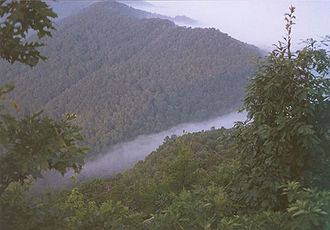
Ein nebliger Morgen am Pinnacle im Cumberland Gap National Historic Park
Passhöhe 488 m Kentucky, Tennessee, Virginia (USA) Ausbau  U.S. Route 25E (Wilderness Road)
Gebirge Cumberland Mountains (Appalachen) Karte 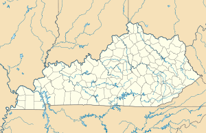

Koordinaten 36° 36′ 14″ N, 83° 40′ 27″ W36.6038-83.6742488Koordinaten: 36° 36′ 14″ N, 83° 40′ 27″ W Cumberland Gap ist der Name eines auf 488 Meter Höhe gelegenen Gebirgspasses in den Cumberland Mountains, einer Bergkette der Appalachen. Berühmt wurde er im 18. und 19. Jahrhundert als Hauptweg der weißen Siedler ins Landesinnere Nordamerikas. Der Pass war Teil der Wilderness Road, einem ehemaligen Indianerpfad, den Daniel Boone mit 35 Männern erweiterte.
Der Pass wurde nach William Augustus, Duke of Cumberland benannt, nach dem einige Plätze in Nordamerika benannt wurden nach der Schlacht von Culloden. Der Pass wechselte vier Mal während des amerikanischen Bürgerkrieges den Besatzer. Im Jahr 1864 nutzte General Ulysses Grant die Wilderness Road und den Cumberland Gap beim Feldzug gegen Tennessee. Grant soll sinngemäß gesagt haben: Mit zwei Brigaden am Cumberland Gap könnte ich den Pass gegen die Armee halten, die Napoleon nach Moskau geführt hat.
Heute ist der Cumberland Gap ein National Historical Park und Teile der Wilderness Road können im Wilderness Road State Park in Virginia besichtigt werden.
 Panoramablick vom Pinnacle Overlook zum Cumberland Gap National Historic Park
 Kategorien:
- Gebirgspass
- Pass in den Vereinigten Staaten
- Appalachen
- National Historical Park, Memorial oder Battlefield (Vereinigte Staaten)


Wikimedia Foundation.