- Culaba
-
Municipality of Culaba Lage von Culaba in der Provinz Biliran 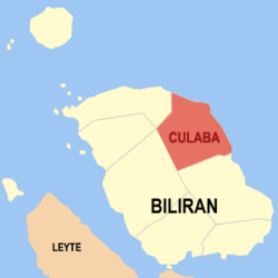
Basisdaten Bezirk: Eastern Visayas Provinz: Biliran Barangays: 17 Distrikt: 1. Distrikt von Biliran PSGC: 087805000 Einkommensklasse: 5. Einkommensklasse Haushalte: 2193 Zensus 1. Mai 2000Einwohnerzahl: 10.962 Zensus 1. August 2007Koordinaten: 11° 39′ N, 124° 33′ O11.65124.55Koordinaten: 11° 39′ N, 124° 33′ O Geographische Lage auf den Philippinen 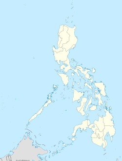

Culaba Culaba ist eine philippinische Stadtgemeinde in der Provinz Biliran. Sie hat 11.506 Einwohner in 2193 Haushalten (Zensus 1. Mai 2000).
Baranggays
Culaba ist politisch unterteilt in 17 Baranggays.
- Acaban
- Bacolod
- Binongtoan
- Bool Central (Pob.)
- Bool East (Pob.)
- Bool West (Pob.)
- Calipayan
- Guindapunan
- Habuhab
- Looc
- Marvel (Pob.)
- Patag
- Pinamihagan
- Culaba Central (Pob.)
- Salvacion
- San Roque
- Virginia (Pob.)
Schlagen Sie auch in anderen Wörterbüchern nach:
Culaba — Saltar a navegación, búsqueda Mapa de Bilirán mostrando la ubicación de Culaba Culaba es un municipio de quinta clase en la provincia de Bilirán, Filipinas. Conforme al censo de 2000, tenía una población de 11.506 habitantes distribuidos en 2.193 … Wikipedia Español
Culaba — Original name in latin Culaba Name in other language Culaba State code PH Continent/City Asia/Manila longitude 11.65778 latitude 124.5425 altitude 1 Population 6231 Date 2011 07 31 … Cities with a population over 1000 database
Culaba, Biliran — Map of Biliran showing the location of Culaba Culaba is a 5th class municipality in the province of Biliran, Philippines. According to the 2000 census, it has a population of 11,506 people in 2,193 households. Barangays Culaba is politically… … Wikipedia
Legislative districts of Leyte — Philippines This article is part of the series: Politics and government of the Philippines … Wikipedia
PH-BIL — Lage der Provinz Biliran Biliran ist eine Insel und seit 1992 eine eigenständige Provinz der Philippinen. Die Provinzhauptstadt ist Naval. Vor ihrer politischen Eigenständigkeit gehörte die Insel zur Provinz Leyte. Die Insel liegt in den… … Deutsch Wikipedia
Biliran Island — Infobox Islands name = Biliran Island image caption = NASA Landsat image of Biliran. native name = native name link = locator Location map|Philippines|lat=11.523|long=124.535|width=175 map custom = yes location = South East Asia coordinates=… … Wikipedia
Biliran — 11.523333333333124.535 Koordinaten: 11° 31′ N, 124° 32′ O … Deutsch Wikipedia
Biliran (volcano) — Biliran Elevation 1,301 m (4,268 ft) Location Location … Wikipedia
Biliran — This article is about the province. For the municipality, see Biliran, Biliran. For the Island see Biliran Island. Infobox Philippine province name = Biliran sealfile = Ph seal biliran.png region = Eastern Visayas (Region VIII) capital = Naval… … Wikipedia
De La Salle University — Pamantasang De La Salle Motto Religio, Mores, Cultura Motto in English Religion, Morals, Culture Established 1911 … Wikipedia
Culaba


18+
© Academic, 2000-2024
- Kontaktieren Sie uns: Unterstützung, Werbung
Wörterbücher Export, schritte mit PHP, Joomla, Drupal, WordPress, MODx.