Crug Hywel

Crug Hywel
Crug Hywel
Crug Hywel.jpg
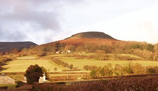
Höhe 451 m ASL
Lage Wales
Gebirge Black Mountains
Geographische Lage 51° 52′ 46″ N, 3° 7′ 38″ W51.87946-3.12727451Koordinaten: 51° 52′ 46″ N, 3° 7′ 38″ W
Crug Hywel (Wales)
Crug Hywel
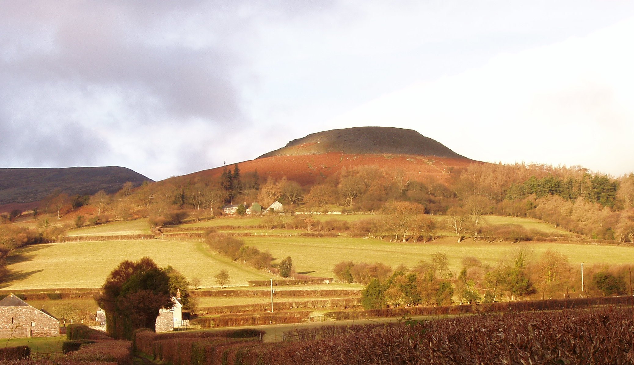
Typ Tafelberg

Crug Hywel (walisisch, die englische Bezeichnung lautet Table Mountain, Tafelberg) ist ein 451 m hoher, abgeflachter Hügel am südlichen Rande der Black Mountains in Wales im Brecon Beacons National Park. Er liegt an der Südflanke des 701 m hohen Pen Cerrig-calch und überragt die im Süden liegende Stadt Crickhowell, von der er seinen Namen hat.

Der Gipfel des Hügels besteht aus einem nierenförmigen eisenzeitlichen Hillfort mit deutlich sichtbaren Erd- und Steinwällen und einem dazwischen liegenden Graben.

Weblinks


Wikimedia Foundation.

Игры ⚽ Поможем написать реферат

Schlagen Sie auch in anderen Wörterbüchern nach:

  • Crug Hywel — Crug Hywel, or Table Mountain, Black Mountains Elevation 451 m (1,480 ft) …   Wikipedia

  • Crug — is a Welsh word meaning hillock, cairn or barrow, and may refer to: Bryn crug, Wales Crug Hywel Battle of Crug Mawr See also Krug (disambiguation) This disambiguation page lists articles associated with the same title. If an …   Wikipedia

  • Crickhowell — Coordinates: 51°51′35″N 3°08′14″W / 51.8597°N 3.1372°W / 51.8597; 3.1372 …   Wikipedia

  • Black Mountains, Wales — The Black Mountains ( cy. Y Mynyddoedd Duon) are a group of hills in south eastern Wales [http://www.geograph.org.uk/photo/588242] , and a small part of Herefordshire, England [http://www.geograph.org.uk/photo/278122] . LocationThey are the… …   Wikipedia

  • Table Mountain (disambiguation) — Table mountain may refer to: *Table (landform)Table Mountain may refer to: * Table Mountain in Cape Town, South Africa, is perhaps the most famous example. ** This is the mountain referred to in the name of the Declaration of Table Mountain, a… …   Wikipedia

  • The Beacons Way — [http://www.geograph.org.uk/photo/476809] is a waymarked long distance footpath in the Brecon Beacons National Park in south Wales, United Kingdom. Distance The Beacons Way runs for 161 km / 100 miles through the National Park. Development Route… …   Wikipedia

  • Black Mountains (Wales) — Die Black Mountains (walisisch: Y Mynyddoedd Duon) sind eine Hügelgruppe in einem vom Tourismus noch unberührten Heidegebiet im südöstlichen Wales und einem kleinen Teil von Herefordshire in England. Sie ist die östlichste der drei Hügelgruppen… …   Deutsch Wikipedia

  • Gwynedd in the High Middle Ages — is a period in the History of Wales spanning the 11th, 12th, and 13th centuries (AD 1000 ndash;1300). The High Middle Ages were preceded by the Early Middle Ages and followed by the Late Middle Ages. Gwynedd is located in the north of… …   Wikipedia

  • Kingdom of Gwynedd — Infobox Former Country native name = Teyrnas Gwynedd conventional long name = Kingdom of GwyneddRef|1 common name = Gwynedd |continent = Europe region = British Isles country = Wales era = Middle Ages government type = Monarchy |event start =… …   Wikipedia

  • Criccieth — Coordinates: 52°55′01″N 4°14′11″W / 52.91697°N 4.23626°W / 52.91697; 4.23626 …   Wikipedia

Share the article and excerpts

Direct link
Do a right-click on the link above
and select “Copy Link”