- Crewe and Nantwich
-
Borough of Crewe and Nantwich 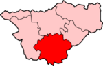
Lage in CheshireStatus Borough Region North West England Verw.grafschaft Cheshire Verwaltungssitz Crewe Fläche 430,41 km² (112.) Einwohner 116.600 (180.) ONS-Code 13UD Website - Gründung 1974 Auflösung 2009 Crewe and Nantwich war ein District mit dem Status eines Borough in der Grafschaft Cheshire in England. Verwaltungssitz war die Stadt Crewe, in der etwas mehr als die Hälfte der Bevölkerung lebte. Weitere bedeutende Orte waren Audlem, Haslington, Nantwich, Willaston und Wistaston.
Der Bezirk wurde am 1. April 1974 gebildet und entstand aus der Fusion des Borough of Crewe, des Urban District Nantwich und des Rural District Nantwich. Am 1. April 2009 wurde er aufgrund einer Gebiets- und Verwaltungsreform aufgelöst und ging in der neuen Unitary Authority Cheshire East auf.
Chester | Congleton | Crewe and Nantwich | Ellesmere Port and Neston | Macclesfield | Vale Royal
Wikimedia Foundation.
Schlagen Sie auch in anderen Wörterbüchern nach:
Crewe and Nantwich — This article is about the borough. For the constituency, see Crewe and Nantwich (UK Parliament constituency). Borough of Crewe and Nantwich Shown within Cheshire Geography … Wikipedia
Crewe and Nantwich (UK Parliament constituency) — Crewe and Nantwich County constituency for the House of Commons Boundary of Crewe and Nantwich in Cheshire … Wikipedia
Crewe and Nantwich by-election, 2008 — Crewe and Nantwich by election 2005 ← 22 May 2008 → 2010 … Wikipedia
Crewe and Nantwich (disambiguation) — Crewe and Nantwich can refer to: Crewe and Nantwich local government district of Cheshire, England Crewe and Nantwich constituency of the United Kingdom Parliament, based on the local government district but not sharing the same borders. The… … Wikipedia
Crewe and Nantwich local elections — One third of Crewe and Nantwich Council is elected each year, followed by one year without election. Contents 1 Political control 2 Council elections 3 By election results 4 External links … Wikipedia
Crewe and Nantwich Circular Walk — Waymarker Crewe and Nantwich Circular Walk … Wikipedia
Crewe and Nantwich — ▪ district, England, United Kingdom borough (district) in the south of the administrative and historic county of Cheshire, England. Crewe has long been associated with the railways and is today a railway and industrial centre. Nantwich is… … Universalium
Willaston, Crewe and Nantwich — infobox UK place country = England official name= Willaston latitude= 53.082 longitude= 2.479 population= 2,277(2001 Census) shire district= Crewe and Nantwich region= North West England shire county = Cheshire constituency westminster=Crewe and… … Wikipedia
Chorlton, Crewe and Nantwich — Chorlton is a village gbmappingsmall|SJ728504 and civil parish in the Crewe and Nantwich district of Cheshire, England. The village lies 4 miles to the south east of Crewe. Nearby villages include Betley, Hough, Shavington, Weston and Wybunbury.… … Wikipedia
Chorley, Crewe and Nantwich — Chorley is a hamlet (at gbmappingsmall|SJ574511) and civil parish in the Crewe and Nantwich district of Cheshire, England. The hamlet lies 5 miles to the west of Nantwich and 6 miles to the north east of Malpas. Nearby villages include Faddiley,… … Wikipedia
Crewe and Nantwich

18+
© Academic, 2000-2024
- Kontaktieren Sie uns: Unterstützung, Werbung
Wörterbücher Export, schritte mit PHP, Joomla, Drupal, WordPress, MODx.