- County Down
-
County Down
Contae an DúinKarte 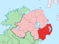
Basisdaten Staat: Vereinigtes Königreich Verwaltungssitz: Downpatrick Provinz: Ulster irischer Name: An Dún Fläche: 2465 km² Einwohner: 454.000 (Schätzung) Down (irisch An Dún) ist eine der sechs historischen Grafschaften (Countys) Nordirlands.
Inhaltsverzeichnis
Geografie
Das County liegt zwischen dem Carlingford Lough, dem Fluss Bann, Belfast Lough und der Irischen See. Die Landschaft ist durch die letzte Eiszeit geprägt. Höhere Erhebungen gibt es nur im Süden mit den Mourne Mountains und in Zentral-Down mit dem Clieve Croob.
Geschichte
Die Grafschaft hat eine lange Vorgeschichte, in der der Bau von Megalithanlagen eine herausragende Rolle spielt. Die Geschichte von Down ist bis zur Teilung der Insel Teil der Geschichte Irlands; siehe dort. Die historische Schlacht von Mag Ráth (Moira im County Down) im Jahre 637 ist in mythischer Form in der Erzählung Cath Maige Rátha im Leabhar Buidhe Lecain („Das gelbe Buch von Lecan“) erhalten.
Wirtschaft
25 Prozent der landwirtschaftlichen Fläche werden für den Ackerbau (Gerste, Kartoffeln, Gemüse) genutzt, 75 Prozent für Viehhaltung (Rinder, Schweine, Geflügel, Schafe). Entlang der Küste wird Fischfang betrieben und es liegen dort mehrere bedeutende Seebäder.
In der Umgebung von Belfast ist die Industrie konzentriert. Vorrangig existiert eine Maschinenbau-, Elektro- und Computer- sowie Textilindustrie.
Städte
- Ardglass
- Banbridge
- Bangor
- Comber
- Downpatrick
- Dromore
- Dundonald
- Holywood
- Kilkeel
- Lisburn (gehört teilweise zum County Antrim)
- Moira
- Newcastle
- Newry
- Newtownards
Sehenswürdigkeiten
 Portal tomb Goward mit dem für diese Gattung typischen riesigen Deckstein
- Dolmen von Annadorn
- Audleystown (Cairn)
- Steinkreis von Ballynoe
- Drumena Cashel, (Dun)
- Dunnaman (Court tomb)
- Giant’s Ring (Steinkreis)
- Goward (Portal tomb)
- Inch Abbey
- Jordan’s Castle
- Kilfeaghan (Portal tomb)
- Kilteagh (Dolmen)
- Kirche am St. John’s Point
- Kirchen von Killevy
- Legananny (Dolmen)
- Millin Bay (Cairn)
- Nendrum-Kloster
Persönlichkeiten
- Robert Ross, Offizier der britischen British Army (1766–1814)
- Robert Stewart, 2. Marquess of Londonderry, britischer Staatsmann (1769–1822)
- Francis Crozier, Offizier der britischen Royal Navy und Polarfahrer (1796–1848)
- Arthur Edward Kennedy, Politiker und britischer Kolonialbeamter (1809–1883)
- Colin Blakely, Schauspieler (1930–1987)
- Pat Jennings, Fußballspieler (* 1945)
- Rose Marie, Sängerin (* 1956)
- Gary Lightbody, Sänger und Frontmann der Rockband Snow Patrol (* 1976)
 Historische Grafschaften (counties) von Nordirland
Antrim | Armagh | Down | Fermanagh | Londonderry | Tyrone
Wikimedia Foundation.
Schlagen Sie auch in anderen Wörterbüchern nach:
County Down — Contae an Dúin Coontie Doon / Countie Doun Coat of arms … Wikipedia
County Down (United Kingdom) — Hotels: Slieve Donard Resort & Spa (Newcastle) … International hotels
County Down Spectator — The County Down Spectator and Ulster Standard is a weekly newspaper based in Bangor, County Down, Northern Ireland. It generally serves the area covered by the North Down parliamentary constituency. it is published by Spectator Newspapers and has … Wikipedia
County Down — Comté de Down Pour les articles homonymes, voir Down. Comté de Down Contae An Dúin [[Image: |175px|Drapeau de Comté de Down]] … Wikipédia en Français
Downpatrick and County Down Railway — Coordinates: 54°19′34″N 5°43′19″W / 54.326°N 5.722°W / 54.326; 5.722 … Wikipedia
Belfast and County Down Railway — Станция Хеленс Бэй Be … Википедия
Newcastle, County Down — Coordinates: 54°12′36″N 5°52′55″W / 54.21°N 5.882°W / 54.21; 5.882 … Wikipedia
Moira, County Down — Coordinates: 54°28′48″N 6°13′55″W / 54.480°N 6.232°W / 54.480; 6.232 … Wikipedia
Dundrum, County Down — For other places with the same name, see Dundrum (disambiguation). Coordinates: 54°15′N 5°51′W / 54.25°N 5.85°W / 54.25; 5.85 … Wikipedia
Dromore, County Down — Not to be confused with Dromore, County Tyrone. Coordinates: 54°24′54″N 6°08′56″W / 54.415°N 6.149°W / 54.415; 6.149 … Wikipedia
County Down


18+
© Academic, 2000-2024
- Kontaktieren Sie uns: Unterstützung, Werbung
Wörterbücher Export, schritte mit PHP, Joomla, Drupal, WordPress, MODx.