- County Armagh
-
County Armagh
Contae Ard MhachaKarte 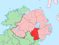
Basisdaten Staat: Vereinigtes Königreich Verwaltungssitz: Armagh Provinz: Ulster irischer Name: Ard Macha Fläche: 1327 km² Einwohner: 141.000 (Schätzung) Armagh (irisch: Ard Mhacha) ist eine der sechs historischen Grafschaften (engl. county) im nordirischen Teil der Insel Irland.
Inhaltsverzeichnis
Geografie
Die Grafschaft liegt südlich des Lough Neagh. Der Norden besteht aus fruchtbaren Ebenen, die von den Flüssen Bann und Blackwater durchflossen werden. Im Süden erstreckt sich ein Hügelland bis zu einer Höhe von 550 Metern.
Geschichte
Die Grafschaft hat eine lange Vorgeschichte, in der der Bau von Megalithanlagen eine herausragende Rolle spielt. Später gehörte sie zu dem Königreich Ulster, aus dem im 5. Jahrhundert das Königreich Oriel hervorging. In frühchristlicher Zeit wurde der gleichnamige Hauptort zum Bischofssitz, der mit St. Patrick in Verbindung gebracht wird. Zahlreiche Hinweise darauf finden sich u. a. im Buch of Armagh. Ende des 12. Jahrhunderts wurde das Gebiet von den Anglonormannen erobert und kam unter englische Herrschaft. Die normannischen Herrscher lösten sich allerdings bald wieder von der englischen Herrschaft, die erst Mitte des 17. Jahrhunderts wiedererstarkte (Oliver Cromwell). In diese Zeit fällt auch die Gründung der Grafschaft.
Wirtschaft
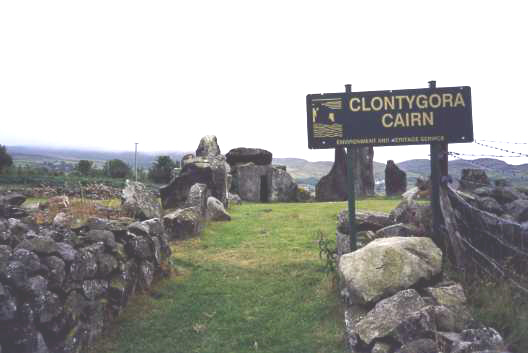
 Clontygora
 Clontygora
Im Norden befindet sich das wichtigste Apfelanbaugebiet Irlands, im hügeligen Süden herrscht die Schafzucht vor. Es gibt Nahrungsmittel-, Bekleidungs-, Möbel-, und Leichtindustrie.
Städte
Sehenswürdigkeiten
- Annaghmare Court Cairn
- Ballykeel Dolmen
- Ballymacdermot Court Cairn
- Clonlum Nord- und Südcairn
- Clontygora Cairn
- Fort Navan
- Slieve Gullion Nord- und Südcairn
- Kirchen von Killevy
 Historische Grafschaften (counties) von Nordirland
Antrim | Armagh | Down | Fermanagh | Londonderry | Tyrone
Wikimedia Foundation.
Schlagen Sie auch in anderen Wörterbüchern nach:
County Armagh — Contae Ard Mhacha Coontie Airmagh / Armagh Coat of arms … Wikipedia
Middletown, County Armagh — Coordinates: 54°17′34″N 6°50′38″W / 54.29274°N 6.84388°W / 54.29274; 6.84388 … Wikipedia
Creggan, County Armagh — Creggan (from Irish: an Creagán)[1] is a small village and townland near Crossmaglen in County Armagh, Northern Ireland. In the 2001 Census it had a population of 246 people. It lies within the Newry and Mourne District Council area. Contents 1… … Wikipedia
Collegeland, County Armagh — Coordinates: 54°25′30″N 6°39′22″W / 54.425°N 6.656°W / 54.425; 6.656 Collegeland is a small vill … Wikipedia
Clonmore, County Armagh — For other places with the same name, see Clonmore (disambiguation). Clonmore (from Irish: Cluain Mór meaning large meadow )[1] is a hamlet and townland in County Armagh, Northern Ireland. It is close to the banks of the River Blackwater. Contents … Wikipedia
Milford, County Armagh — Coordinates: 54°20′02″N 6°41′02″W / 54.334°N 6.684°W / 54.334; 6.684 Milford or Millford is a small … Wikipedia
Kilmore, County Armagh — Kilmore is a small village in County Armagh, Northern Ireland, 2.5 miles north of Richhill and 6 miles north of Armagh, off the A3 Armagh to Portadown road . In the 2001 Census it had a population of 111 people. It is situated within the Armagh… … Wikipedia
Richhill, County Armagh — Richhill is a large village in County Armagh, Northern Ireland, centrally located between Armagh and Portadown. In the 2001 Census it had a population of 2,818 people.Richhill takes its name from Edward Richardson, Member of Parliament for County … Wikipedia
Jonesborough, County Armagh — Jonesborough is a small village in County Armagh, Northern Ireland, less than a mile from the border with County Louth in the Republic of Ireland in the Ring of Gullion. It is about 5 miles south of Newry. In the 2001 Census it had a population… … Wikipedia
The Birches, County Armagh — The Birches is a small village in County Armagh, Northern Ireland, 6 miles north west of Portadown and close to junction 12 on the M1 Motorway. In the 2001 Census it had a population of 150 people. It is situated in Craigavon Borough Council area … Wikipedia
County Armagh


18+
© Academic, 2000-2024
- Kontaktieren Sie uns: Unterstützung, Werbung
Wörterbücher Export, schritte mit PHP, Joomla, Drupal, WordPress, MODx.