- Coolamon Shire
-
Shire of Coolamon 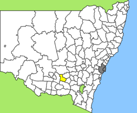
Lage des Coolamon Shire in New South WalesGliederung Staat:  Australien
Bundesstaat:  New South Wales
Verwaltungssitz: Coolamon Daten und Zahlen Fläche: 2.433 km² Einwohner: 4.028 (2006) [1] Bevölkerungsdichte: 1,7 Einwohner je km² -34.833333333333147.2Koordinaten: 34° 50′ S, 147° 12′ OCoolamon Shire ist ein lokales Verwaltungsgebiet (LGA) im australischen Bundesstaat New South Wales. Das Gebiet ist 2.433 km² groß und hat etwa 4.000 Einwohner.
Coolamon liegt im Süden des Staates in der Murrumbidgee-Region etwa 500 km südwestlich der Metropole Sydney, 290 km nordwestlich von Canberra und 480 km nordöstlich von Melbourne. Das Gebiet umfasst 28 Ortsteile und Ortschaften: Ashbridge, Berry Jerry, Berry Jerry North, Brushwood, Carlisle Park, Cowabbie, Cowabbie West, Derain, Dulah, Kindra, Kinilabah, Methul, Murrulebale, Pamandi, Rannock, Walleroobie, Winchendon Vale, Yarranjerry sowie Teile von Ardlethan, Beckom, Coolamon, Ganmain, Grong Grong, Kamarah, Marrar, Matong, Mimosa und Mirrool. Der Sitz des Shire Councils befindet sich in Coolamon im Süden der LGA, wo etwa 1.300 Einwohner leben.
Verwaltung
Der Coolamon Shire Council hat neun Mitglieder, die von den Bewohnern der LGA gewählt werden. Coolamon ist nicht in Bezirke untergliedert. Aus dem Kreis der Councillor rekrutiert sich auch der Mayor (Bürgermeister) des Councils.
Weblinks
Einzelnachweise
- ↑ Australian Bureau of Statistics (25. Oktober 2007): Coolamon (A) (Local Government Area) (Englisch). 2006 Census QuickStats. Abgerufen am 6. April 2010.
Kategorie:- Local Government Area in New South Wales

Wikimedia Foundation.