Conargo Shire

Conargo Shire
Shire of Conargo
Australia-Map-NSW-LGA-Conargo.png
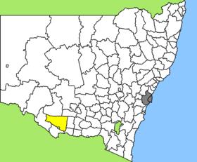
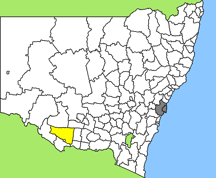
Lage des Conargo Shire in New South Wales
Gliederung
Staat: Australien Australien
Bundesstaat: Flag of New South Wales.svg New South Wales
Verwaltungssitz: Conargo
Daten und Zahlen
Fläche: 8.751 km²
Einwohner: 1.675 (2006) [1]
Bevölkerungsdichte: 0,2 Einwohner je km²
Wards: 4
-35.316666666667145.15

Conargo Shire ist ein lokales Verwaltungsgebiet (LGA) im australischen Bundesstaat New South Wales. Das Gebiet ist 8.751 km² groß und hat mit etwas über 1.700 die drittkleinste Einwohnerzahl aller LGAs des Staates.

Conargo liegt im Süden des Staates in der Region um den Grenzfluss Murray River etwa 500 km westlich der australischen Hauptstadt Canberra und 330 km nördlich von Melbourne. Das Gebiet umfasst 45 Ortsteile und Ortschaften, darunter Blighty, Booroorban, Conargo, Mayrung, Pretty Pine, Wanganella und ein Teil von Deniliquin. Conargo ist die einzige LGA, in der der Council seinen Sitz nicht im Hauptort hat, sondern im nächstgrößeren Ort, in Deniliquin am Südrand der LGA. Die Ortschaft Conargo, die im Ostteil des Verwaltungsgebiets liegt, hat nur um die 190 Einwohner.

Verwaltung

Der Conargo Shire Council hat acht Mitglieder, die von den Bewohnern der vier Wards gewählt werden (je zwei aus Conargo, Blighty, Mayrung und Windouran Ward). Diese vier Bezirke sind unabhängig von den Ortschaften festgelegt. Aus dem Kreis der Councillor rekrutiert sich auch der Mayor (Bürgermeister) des Councils.

Weblinks

Einzelnachweise

  1. Australian Bureau of Statistics (25. Oktober 2007): Conargo (A) (Local Government Area) (Englisch). 2006 Census QuickStats. Abgerufen am 6. April 2010.

Wikimedia Foundation.

Игры ⚽ Поможем сделать НИР

Schlagen Sie auch in anderen Wörterbüchern nach:

  • Conargo Shire — New South Wales Location in New South Wales Population: 1,700(2009) …   Wikipedia

  • Conargo Shire Council — Infobox Australian Place | type = lga name = Conargo Shire state = nsw caption = Location in NSW pop = 1,417 density = 0.16 area = 8751 est = seat = Conargo (Offices in neighbouring Deniliquin, 122 End Street) mayor = Norm McAllister region =… …   Wikipedia

  • Conargo, New South Wales — Conargo New South Wales The famed Conargo Pub praised by the Ute Muster sub culture …   Wikipedia

  • Wakool Shire — Shire of Wakool New South Wales Location in New South Wales Population: 4,427(2009) …   Wikipedia

  • Murray Shire — This article is about the Murray Shire in New South Wales. For the Western Australia shire, see Shire of Murray. Murray Shire New South Wales …   Wikipedia

  • Murrumbidgee Shire — New South Wales Murrumbidgee Shire office and chambers Populat …   Wikipedia

  • Murray Shire Council — Infobox Australian Place | type = lga name = Murray Shire state = nsw caption = Location in NSW pop = 6,604 density = 1.5 area = 4345 est = seat = Mathoura (21 25 Conargo Street) mayor = Brian Sharp region = Riverina url =… …   Wikipedia

  • Narrandera Shire — New South Wales Location in New South Wales Population: 6 …   Wikipedia

  • Corowa Shire — New South Wales Location in New South Wales Population: 11,685(2009) …   Wikipedia

  • Jerilderie Shire Council — Infobox Australian Place | type = lga name = Jerilderie Shire caption = Jerilderie Shire Council office and chambers. state=New South Wales region=Riverina area=3375 seat=Jerilderie (35 Jerilderie Street}cite web title=Jerilderie Shire Council… …   Wikipedia

Share the article and excerpts

Direct link
Do a right-click on the link above
and select “Copy Link”