- Columbia County (New York)
-
Verwaltung US-Bundesstaat: New York Verwaltungssitz: Hudson Gründung: 1786 Gebildet aus: Albany County Vorwahl: 001 518 Demographie Einwohner: 63.094 (2000) Bevölkerungsdichte: 38,3 Einwohner/km² Geographie Fläche gesamt: 1.679 km² Wasserfläche: 32 km² Karte 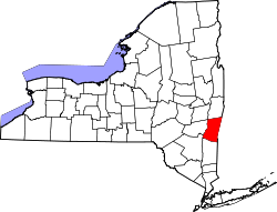
Website: www.columbiacountyny.com Columbia County[1] ist ein County im Bundesstaat New York der Vereinigten Staaten von Amerika. Bei der Volkszählung im Jahr 2000 hatte das County 63.094 Einwohner und eine Bevölkerungsdichte von 38 Einwohnern pro Quadratkilometer. Der Verwaltungssitz (County Seat) ist Hudson.
Geographie
Das County hat eine Fläche von 1.679 Quadratkilometern, wovon 32 Quadratkilometer Wasserfläche sind. Columbia County grenzt im Norden an Rensselaer County, im Osten an Massachusetts, im Süden an Dutchess County und im Westen an Greene County.
Städte und Ortschaften
- Ancram
- Austerlitz
- Canaan
- Chatham
- Claverack
- Clermont
- Copake Lake
- Copake
- Gallatin
- Germantown
- Ghent
- Greenport
- Hillsdale
- Hudson
- Kinderhook
- Livingston
- Lorenz Park
- New Lebanon
- Niverville
- Philmont
- Stockport
- Stottville
- Stuyvesant
- Taghkanic
- Valatie
Einzelnachweise
- ↑ GNIS-ID: 974109. Abgerufen am 22. Februar 2011 (englisch).

Liste der Countys in New York
Albany | Allegany | Bronx | Broome | Cattaraugus | Cayuga | Chautauqua | Chemung | Chenango | Clinton | Columbia | Cortland | Delaware | Dutchess | Erie | Essex | Franklin | Fulton | Genesee | Greene | Hamilton | Herkimer | Jefferson | Kings (Brooklyn) | Lewis | Livingston | Madison | Monroe | Montgomery | Nassau | New York (Manhattan) | Niagara | Oneida | Onondaga | Ontario | Orange | Orleans | Oswego | Otsego | Putnam | Queens | Rensselaer | Richmond (Staten Island) | Rockland | Saratoga | Schenectady | Schoharie | Schuyler | Seneca | St. Lawrence | Steuben | Suffolk | Sullivan | Tioga | Tompkins | Ulster | Warren | Washington | Wayne | Westchester | Wyoming | Yates
Wikimedia Foundation.
Schlagen Sie auch in anderen Wörterbüchern nach:
Columbia County, New York — There is also a Town of Columbia in New York. Columbia County, New York Seal … Wikipedia
National Register of Historic Places listings in Columbia County, New York — Location of Columbia County in New York … Wikipedia
Greenport, Columbia County, New York — Greenport is also a village in Suffolk County, New York . Greenport is a town in Columbia County, New York, United States. The population was 4,180 at the 2000 census.The Town of Greenport is on the west border of the county and surrounds the… … Wikipedia
Columbia Island (New York) — Columbia Island through telescope mounted in Pelham Bay Park. Columbia Island, known before 1941 as Little Pea Island, is an island in Long Island Sound and part of New Rochelle, New York. It is about 150 ft square. It is situated between Davids… … Wikipedia
County Route 83 (Suffolk County, New York) — County Route 83 Route information Maintained by SCDPW Length: 11.55 mi … Wikipedia
Dutchess County, New York — Dutchess redirects here. For other uses, see Dutchess (disambiguation). Dutchess County, New York Location in the state of New York … Wikipedia
Greene County, New York — Infobox U.S. County county = Greene County state = New York map size = 250 founded = March 3, 1800 seat = Catskill | area total sq mi =658 area land sq mi =648 area water sq mi =10 area percentage = 1.58% census yr = 2000 pop = 48195 density km2 … Wikipedia
Richmond County (New York) — Verwaltung US Bundesstaat: New York Verwaltungssitz: Adresse des Verwaltungssitzes: Gründung: 1683 … Deutsch Wikipedia
Rensselaer County, New York — Infobox U.S. County county = Rensselaer County state = New York map size = 250 founded = 1791 seat = Troy | area total sq mi =665 area land sq mi =654 area water sq mi =11 area percentage = 1.72% census yr = 2000 pop = 152538 density km2 =90 web … Wikipedia
Greenport, Suffolk County, New York — There is also a Greenport, Columbia County, New York . Infobox Settlement official name = Greenport, New York settlement type = Village nickname = motto = imagesize = 250px image caption = Monument to the September 11 attacks on the Greenport… … Wikipedia
Columbia County (New York)

18+
© Academic, 2000-2024
- Kontaktieren Sie uns: Unterstützung, Werbung
Wörterbücher Export, schritte mit PHP, Joomla, Drupal, WordPress, MODx.