- Coal County
-
Verwaltung US-Bundesstaat: Oklahoma Verwaltungssitz: Coalgate Adresse des
Verwaltungssitzes:County Courthouse
4 N Main
Coalgate, OK 74538-2844Gründung: 16. Juli 1907 Gebildet aus: Choctaw-Land Vorwahl: 001 580 Demographie Einwohner: 5925 (2010) Bevölkerungsdichte: 4,4 Einwohner/km² Geographie Fläche gesamt: 1.350 km² Wasserfläche: 8 km² Karte 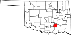
Das Coal County[1] ist ein County im US-amerikanischen Bundesstaat Oklahoma. Bei der Volkszählung im Jahr 2010 hatte das County 5.925 Einwohner und eine Bevölkerungsdichte von 4,4 Einwohnern pro Quadratkilometer. Der Verwaltungssitz (County Seat) ist Coalgate.[2]
Inhaltsverzeichnis
Geografie
Das County liegt im mittleren Südosten von Oklahoma, ist im Süden etwa 90 km von Texas entfernt und hat eine Fläche von 1.350 Quadratkilometern, wovon 8 Quadratkilometer Wasserfläche sind. Es grenzt an folgende Countys:
Hughes County Pittsburg County Pontotoc County 
Johnston County Atoka County Geschichte
Das Coal County wurde am 16. Juli 1907 als Original-County aus Choctaw-Land gebildet. Benannt wurde es nach den hier ab dem 19. Jahrhundert abgebauten Kohlevorkommen.
Demografische Daten
Historische Einwohnerzahlen Census Einwohner ± in % 1910 15.817 — 1920 18.406 20 % 1930 11.521 -40 % 1940 12.811 10 % 1950 8056 -40 % 1960 5546 -30 % 1970 5525 -0,4 % 1980 6041 9 % 1990 5780 -4 % 2000 6031 4 % 2010 5925 -2 % 1900–1990[3] 2000[4] 2010[5] Nach der Volkszählung im Jahr 2010 lebten im Coal County 5.925 Menschen in 2.344 Haushalten. Die Bevölkerungsdichte betrug 4,4 Einwohner pro Quadratkilometer.
Ethnisch betrachtet setzte sich die Bevölkerung zusammen aus 74,3 Prozent Weißen, 0,5 Prozent Afroamerikanern, 16,7 Prozent amerikanischen Ureinwohnern, 0,2 Prozent Asiaten sowie aus anderen ethnischen Gruppen; 7,8 Prozent stammten von zwei oder mehr Ethnien ab. Unabhängig von der ethnischen Zugehörigkeit waren 2,6 Prozent der Bevölkerung spanischer oder lateinamerikanischer Abstammung.
In den 2.344 Haushalten lebten statistisch je 2,43 Personen.
25,5 Prozent der Bevölkerung waren unter 18 Jahre alt, 56,7 Prozent waren zwischen 18 und 64 und 17,8 Prozent waren 65 Jahre oder älter. 50,6 Prozent der Bevölkerung war weiblich.
Das jährliche Durchschnittseinkommen eines Haushalts lag bei 31.666 USD. Das Pro - Kopf - Einkommen betrug 16.827 USD. 21,2 Prozent der Einwohner lebten unterhalb der Armutsgrenze.[6]
Städte und Gemeinden
- Centrahoma
- Coalgate
- Lehigh
- Bromide1
- Phillips
- Tupelo
- Cairo
- Clarita
- Cottonwood
- East Jessie
- Olney
- Parker
1 - teilweise im Johnston County
Einzelnachweise
- ↑ Coal County im Geographic Names Information System des United States Geological Survey Abgerufen am 22. Februar 2011
- ↑ National Association of Counties Abgerufen am 22. Oktober 2011
- ↑ Auszug aus Census.gov Abgerufen am 28. Februar 2011
- ↑ Auszug aus factfinder.census.gov Abgerufen am 28. Februar 2011
- ↑ United States Census 2010 Abgerufen am 22. Oktober 2011
- ↑ U.S. Census Buero, State & County QuickFacts - Coal County Abgerufen am 22. Oktober 2011
Weblinks
-
 Commons: Coal County, Oklahoma – Sammlung von Bildern, Videos und Audiodateien
 - U.S. Census Buero, State & County QuickFacts - Coal County
- Yahoo Bildersuche - Coal County
- www.city-data.com - Coal County

Liste der Countys in Oklahoma
Adair | Alfalfa | Atoka | Beaver | Beckham | Blaine | Bryan | Caddo | Canadian | Carter | Cherokee | Choctaw | Cimarron | Cleveland | Coal | Comanche | Cotton | Craig | Creek | Custer | Delaware | Dewey | Ellis | Garfield | Garvin | Grady | Grant | Greer | Harmon | Harper | Haskell | Hughes | Jackson | Jefferson | Johnston | Kay | Kingfisher | Kiowa | Latimer | Le Flore | Lincoln | Logan | Love | Major | Marshall | Mayes | McClain | McCurtain | McIntosh | Murray | Muskogee | Noble | Nowata | Okfuskee | Oklahoma | Okmulgee | Osage | Ottawa | Pawnee | Payne | Pittsburg | Pontotoc | Pottawatomie | Pushmataha | Roger Mills | Rogers | Seminole | Sequoyah | Stephens | Texas | Tillman | Tulsa | Wagoner | Washington | Washita | Woods | Woodward
Wikimedia Foundation.
Schlagen Sie auch in anderen Wörterbüchern nach:
Coal County — Admin ASC 2 Code Orig. name Coal County Country and Admin Code US.OK.029 US … World countries Adminstrative division ASC I-II
Coal County, Oklahoma — Location in the state of Oklahoma … Wikipedia
National Register of Historic Places listings in Coal County, Oklahoma — Location of Coal County in Oklahoma This is a list of the National Register of Historic Places listings in Coal County, Oklahoma. This is intended to be a complete list of the properties on the National Register of Historic Places in Coal County … Wikipedia
Coal mining in Kentucky — Coal was discovered in Kentucky in 1750. Since the first commercial coal mine opened in 1820 coal has gained both economic importance and controversy regarding its environmental consequences. As of 2010 there are 442 operating coal mines in the… … Wikipedia
Coal Creek War — A drawing from Harper s Weekly showing Coal Creek miners firing on Fort Anderson in 1892 … Wikipedia
Coal Bluff, Indiana — Coal Bluff Unincorporated town Vigo County s location in Indiana … Wikipedia
Coal Creek Township, Montgomery County, Indiana — Coal Creek Township Township Location in Montgomery County … Wikipedia
Coal City, Utah — Coal City Ghost town … Wikipedia
Coal Palace — Motto: Coal is light, heat, and power. General information Architectural style … Wikipedia
Coal Run Village, Kentucky — City Location of Coal Run Village, Kentucky … Wikipedia
Coal County


18+
© Academic, 2000-2024
- Kontaktieren Sie uns: Unterstützung, Werbung
Wörterbücher Export, schritte mit PHP, Joomla, Drupal, WordPress, MODx.