- Clay County (Missouri)
-
 Das Clay County Courthouse in Liberty
Verwaltung US-Bundesstaat: Missouri Verwaltungssitz: Liberty Adresse des
Verwaltungssitzes:County Courthouse
Courthouse Square
Liberty, MO 64068-2365Gründung: 2. Januar 1822 Gebildet aus: Ray County Vorwahl: 001 816 Demographie Einwohner: 221.939 (2010) Bevölkerungsdichte: 216,1 Einwohner/km² Geographie Fläche gesamt: 1.059 km² Wasserfläche: 32 km² Karte 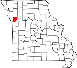
Website: www.claycogov.com
Das Clay County[1] ist ein County im US-amerikanischen Bundesstaat Missouri. Bei der Volkszählung im Jahr 2010 hatte das County 221.939 Einwohner und eine Bevölkerungsdichte von 216,1 Einwohnern pro Quadratkilometer. Der Verwaltungssitz (County Seat) ist Liberty.[2]Das Clay County ist Bestandteil der Metropolregion Kansas City.
Inhaltsverzeichnis
Geografie
Das County liegt im Nordwesten von Missouri, grenzt im Westen an Kansas und im Süden an den Missouri River. Das Clay County hat eine Fläche von 1.059 Quadratkilometern, wovon 32 Quadratkilometer Wasserfläche sind. Es grenzt an folgende Countys:
Clinton County Platte County 
Ray County Wyandotte County
(Kansas)Jackson County Geschichte
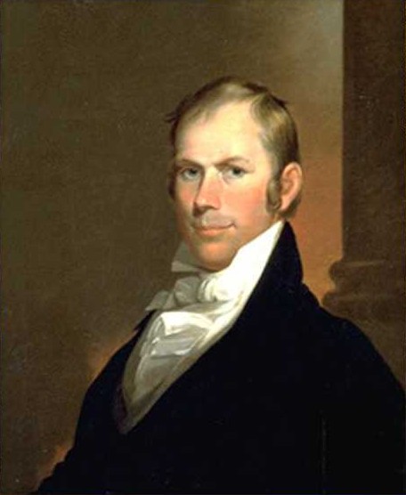
 H. Clay
Das Clay County wurde am 2. Januar 1822 aus Teilen des Ray County gebildet. Benannt wurde es nach Henry Clay (1777-1852) aus Kentucky, einem Mitglied des Repräsentantenhauses, des Senats sowie Außenminister der Vereinigten Staaten.
Demografische Daten
Historische Einwohnerzahlen Census Einwohner ± in % 1830 5338 — 1840 8282 60 % 1850 10.332 20 % 1860 13.023 30 % 1870 15.564 20 % 1880 15.572 0,05 % 1890 19.865 30 % 1900 18.903 -5 % 1910 20.302 7 % 1920 20.455 0,8 % 1930 26.811 30 % 1940 30.417 10 % 1950 45.221 50 % 1960 87.474 90 % 1970 123.322 40 % 1980 136.488 10 % 1990 153.411 10 % 2000 184.006 20 % 2010 221.939 20 % Vor 1900[3] 1900–1990[4] 2000[5] 2010[6] Nach der Volkszählung im Jahr 2010 lebten im Clay County 221.939 Menschen in 86.431 Haushalten. Die Bevölkerungsdichte betrug 216,1 Einwohner pro Quadratkilometer.
Ethnisch betrachtet setzte sich die Bevölkerung zusammen aus 87,5 Prozent Weißen, 5,2 Prozent Afroamerikanern, 0,5 Prozent amerikanischen Ureinwohnern, 2,1 Prozent Asiaten sowie aus anderen ethnischen Gruppen; 2,7 Prozent stammten von zwei oder mehr Ethnien ab. Unabhängig von der ethnischen Zugehörigkeit waren 5,9 Prozent der Bevölkerung spanischer oder lateinamerikanischer Abstammung.
In den 86.431 Haushalten lebten statistisch je 2,48 Personen.
25,2 Prozent der Bevölkerung waren unter 18 Jahre alt, 63,7 Prozent waren zwischen 18 und 64 und 11,1 Prozent waren 65 Jahre oder älter. 51,2 Prozent der Bevölkerung war weiblich.
Das jährliche Durchschnittseinkommen eines Haushalts lag bei 57.983 USD. Das Pro - Kopf - Einkommen betrug 27.828 USD. 7,9 Prozent der Einwohner lebten unterhalb der Armutsgrenze.[8]
Städte und Gemeinden
- Avondale
- Excelsior Springs1
- Gladstone
- Glenaire
- Holt2
- Kansas City3
- Kearney
- Lawson1
- Liberty
- Missouri City
- Mosby
- North Kansas City
- Pleasant Valley
- Smithville4
- Sugar Creek5
- Birmingham
- Claycomo
- Excelsior Estates1
- Oaks
- Oakview
- Oakwood
- Oakwood Park
- Prathersville
- Randolph
1 - teilweise im Ray County
2 - teilweise im Clinton County
3 - teilweise im Cass, Jackson und im Platte County
4 - teilweise im Platte County
5 - teilweise im Jackson CountyEinzelnachweise
- ↑ GNIS-ID: 758478. Abgerufen am 22. Februar 2011 (englisch).
- ↑ National Association of Counties Abgerufen am 14. Oktober 2011
- ↑ U.S. Census Bureau - Census of Population and Housing Abgerufen am 15. März 2011
- ↑ Auszug aus Census.gov Abgerufen am 18. Februar 2011
- ↑ Auszug aus factfinder.census.gov Abgerufen am 18. Februar 2011
- ↑ United States Census 2010 Abgerufen am 14. Oktober 2011
- ↑ Auszug aus dem National Register of Historic Places - Nr. 92001675 Abgerufen am 14. Oktober 2011
- ↑ U.S. Census Buero, State & County QuickFacts - Clay County Abgerufen am 14. Oktober 2011
- ↑ Auszug aus dem National Register of Historic Places - Nr. 66000416 Abgerufen am 14. Oktober 2011
Weblinks
-
 Commons: Clay County, Missouri – Sammlung von Bildern, Videos und Audiodateien
 - Offizielle Webseite
- U.S. Census Buero, State & County QuickFacts - Clay County
- Yahoo Bildersuche - Clay County
- www.city-data.com - Clay County

Liste der Countys in Missouri
Adair | Andrew | Atchison | Audrain | Barry | Barton | Bates | Benton | Bollinger | Boone | Buchanan | Butler | Caldwell | Callaway | Camden | Cape Girardeau | Carroll | Carter | Cass | Cedar | Chariton | Christian | Clark | Clay | Clinton | Cole | Cooper | Crawford | Dade | Dallas | Daviess | DeKalb | Dent | Douglas | Dunklin | Franklin | Gasconade | Gentry | Greene | Grundy | Harrison | Henry | Hickory | Holt | Howard | Howell | Iron | Jackson | Jasper | Jefferson | Johnson | Knox | Laclede | Lafayette | Lawrence | Lewis | Lincoln | Linn | Livingston | Macon | Madison | Maries | Marion | McDonald | Mercer | Miller | Mississippi | Moniteau | Monroe | Montgomery | Morgan | New Madrid | Newton | Nodaway | Oregon | Osage | Ozark | Pemiscot | Perry | Pettis | Phelps | Pike | Platte | Polk | Pulaski | Putnam | Ralls | Randolph | Ray | Reynolds | Ripley | Saline | Schuyler | Scotland | Scott | Shannon | Shelby | St. Charles | St. Clair | St. Francois | St. Louis County | St. Louis City | Ste. Genevieve | Stoddard | Stone | Sullivan | Taney | Texas | Vernon | Warren | Washington | Wayne | Webster | Worth | Wright
Wikimedia Foundation.
Schlagen Sie auch in anderen Wörterbüchern nach:
Clay County, Missouri — Location in the state of Missouri … Wikipedia
National Register of Historic Places listings in Clay County, Missouri — Map of all coordinates from Google Map of all coordinates from Bing … Wikipedia
Clay County Savings Association Building — U.S. National Register of Historic Places … Wikipedia
Clay County — is the name of 18 counties in the United States. Most are named for Henry Clay, U.S. Senator and statesman: Clay County, Alabama Clay County, Arkansas (named for John Clayton, and originally named Clayton County) Clay County, Florida Clay County … Wikipedia
Clay County Sheriff's Office — could refer to several sheriffs departments in the United States, including: Clay County, Alabama Sheriff s Office Clay County, Arkansas Sheriff s Office Clay County, Florida Sheriff s Office Clay County, Georgia Sheriff s Office Clay County,… … Wikipedia
Clay County — ist der Name folgender Countys in den Vereinigten Staaten: Clay County (Alabama) Clay County (Arkansas) Clay County (Florida) Clay County (Georgia) Clay County (Illinois) Clay County (Indiana) Clay County (Iowa) Clay County (Kansas) Clay County… … Deutsch Wikipedia
Clay County, Arkansas — Location in the state of Arkansas … Wikipedia
Clay County, South Dakota — Location in the state of South Dakota … Wikipedia
Clay Township, Adair County, Missouri — Clay Township Township … Wikipedia
Clay Township, Atchison County, Missouri — Clay Township Township … Wikipedia
Clay County (Missouri)


18+
© Academic, 2000-2024
- Kontaktieren Sie uns: Unterstützung, Werbung
Wörterbücher Export, schritte mit PHP, Joomla, Drupal, WordPress, MODx.