- City and District of St Albans
-
City and District of St Albans 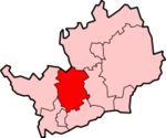
Lage in HertfordshireStatus District und City Region East of England Verw.grafschaft Hertfordshire Verwaltungssitz St Albans Fläche 161,18 km² (205.) Einwohner 132.300 (142.) ONS-Code 26UG Website www.stalbans.gov.uk City and District of St Albans ist ein Verwaltungsbezirk in Hertfordshire, England.
Zum Distrikt gehören
- Die City St Albans (ca. 58.000 Einwohner)
- die Stadt Harpenden (ca. 27.600 Einwohner)
- die Gemeinden Colney Heath, Harpenden Rural, London Colney, Redbourn, St Michael, St Stephen (einschl. der Orte Chiswell Green und Bricket Wood), Sandridge und Wheathampstead.
Der für einen Distrikt ungewöhnliche Name ist aus dem Umstand entstanden, dass in seinem Gebiet zwei städtische Gebiete und mehrere Ortschaften liegen. Normalerweise tragen Distrikte, in denen eine City liegt, auch nur den Namen City of (z. B. City of Peterborough).
Der Distrikt wurde 1974 durch einen Zusammenschluss des St Albans City Council, Harpenden Urban District Council und St Albans Rural District Council gebildet. Der offizielle Name des Distriksrats lautet zwar St Albans District Council, auf allen Fahrzeugen, Briefköpfen und der Webseite wird jedoch die Bezeichnung St. Albans City & District verwendet.
Broxbourne | Dacorum | East Hertfordshire | Hertsmere | North Hertfordshire | St Albans | Stevenage | Three Rivers | Watford | Welwyn Hatfield
Wikimedia Foundation.
Schlagen Sie auch in anderen Wörterbüchern nach:
City and District of St Albans — [cite web |url=http://www.stalbans.gov.uk/local democracy/electoral/results/dcsamay07.htm |title=St Albans District Council Local Democracy Electoral Services District Council Election Results 3rd May 2007 |accessdate=2008 05 02] In the 2007… … Wikipedia
City and County of Swansea Council — The Logo of the City and County of Swansea council … Wikipedia
City of St Albans — Non metropolitan district, Borough, City St Albans Cathedral … Wikipedia
St Albans — infobox UK place country = England latitude= 51.755 longitude= 0.336 official name= St Albans population= 64,038 [ [http://www.hertsdirect.org/infobase/docs/pdfstore/tabKS01sett.pdf Office for National Statistics, 2001 Census, Key Statistics for… … Wikipedia
History of St Albans — St Albans is in southern Hertfordshire, England, around 22 miles (35km) north of London, beside the site of a Catuvellauni settlement and the Roman town of Verulamium. St Albans is Hertfordshire s oldest town, a modern city shaped by over 2000… … Wikipedia
Three Rivers (district) — Three Rivers District Non metropolitan district Three Rivers shown within Hertfordshire … Wikipedia
Clarence Park, St Albans — Clarence Park Full name Clarence Park Location St Albans Built 1893 1894 Opened 23 July 1894 Owner City of St Albans … Wikipedia
St. Albans — St Albans oder St. Albans nach dem Heiligen Alban von England bezeichnet: St Albans, Stadt in der Region City and District of St Albans, Hertfordshire, England City and District of St Albans, Region in Hertfordshire, England St. Albans (Victoria) … Deutsch Wikipedia
St Albans City railway station — Infobox UK station name = St Albans caption = Exterior of the main building on Station Way. code = SAC manager = First Capital Connect locale = St Albans borough = City and District of St Albans usage0405 = 5.340 usage0506 = 5.635 usage0607 =… … Wikipedia
Saint-Albans — DEC … Deutsch Wikipedia
City and District of St Albans

18+
© Academic, 2000-2024
- Kontaktieren Sie uns: Unterstützung, Werbung
Wörterbücher Export, schritte mit PHP, Joomla, Drupal, WordPress, MODx.