- Ľubiša
-
Ľubiša
Wappen Karte 

Ľubiša BasisdatenKraj: Prešovský kraj Okres: Humenné Region: Horný Zemplín Fläche: 10,020 km² Einwohner: 842 (31. Dez. 2010) Bevölkerungsdichte: 84,03 Einwohner je km² Höhe: 178 m n.m. Postleitzahl: 067 11 Telefonvorwahl: 0 57 Geographische Lage: 49° 0′ N, 21° 57′ O49.00333333333321.945555555556178Koordinaten: 49° 0′ 12″ N, 21° 56′ 44″ O Kfz-Kennzeichen: HE Gemeindekennziffer: 520454 StrukturGemeindeart: Gemeinde Verwaltung (Stand: Juli 2011)Bürgermeister: Jozef Sklenčár Adresse: Obecný úrad Ľubiša
129
067 11 ĽubišaWebpräsenz: www.lubisa.estranky.sk Gemeindeinformation
auf portal.gov.skStatistikinformation
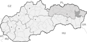
auf statistics.skĽubiša (deutsch Lubische, ungarisch Szerelmes - bis 1907 Lyubis[s]e) ist ein Ort und eine Gemeinde im Okres Humenné (Prešovský kraj) im Osten der Slowakei, mit 842 Einwohnern (Stand 31. Dezember 2010).
Inhaltsverzeichnis
Geographie
Die Gemeinde liegt am südlichen Ende des Berglands Ondavská vrchovina an der linken Seite des Laborec, 10 Kilometer nördlich von Humenné gelegen.
Geschichte
Ľubiša wurde zum ersten Mal 1410 als Libise schriftlich erwähnt, die Siedlung existierte aber wohl vor dem 13. Jahrhundert. Wie viele andere Orte der Gegend war der Ort im Besitz des Geschlechts Drugeth und somit zum Herrschaftsgut von Humenné. 1828 waren 77 Häuser und 513 Einwohner zu verzeichnen. Die Haupteinnahmequellen waren Landwirtschaft und Handwerk.
Sehenswürdigkeiten
- barock-klassizistische römisch-katholische Erzengel-Michael-Kirche aus dem Jahr 1771, seit 1996 in ihrer Funktion als Pfarrkirche durch eine neue Kirche nebenan ersetzt
Persönlichkeiten
- Michal Kováč, erster Staatspräsident der heutigen Slowakei
Gemeinden im Okres HumennéAdidovce | Baškovce | Brekov | Brestov | Černina | Dedačov | Gruzovce | Hankovce | Hažín nad Cirochou | Hrabovec nad Laborcom | Hrubov | Hudcovce | Humenné (Homenau) | Chlmec | Jabloň | Jankovce | Jasenov | Kamenica nad Cirochou | Kamienka | Karná | Kochanovce | Košarovce | Koškovce | Lackovce | Lieskovec | Lukačovce | Ľubiša | Maškovce | Modra nad Cirochou | Myslina | Nechválova Polianka | Nižná Jablonka | Nižná Sitnica | Nižné Ladičkovce | Ohradzany | Pakostov | Papín | Porúbka | Prituľany | Ptičie | Rohožník | Rokytov pri Humennom | Rovné | Ruská Kajňa | Ruská Poruba | Slovenská Volová | Slovenské Krivé | Sopkovce | Topoľovka | Turcovce | Udavské | Valaškovce | Veľopolie | Víťazovce | Vyšná Jablonka | Vyšná Sitnica | Vyšné Ladičkovce | Vyšný Hrušov | Závada | Závadka | Zbudské Dlhé | Zubné
Wikimedia Foundation.
Schlagen Sie auch in anderen Wörterbüchern nach:
Ľubiša — (Village) Administration Pays Slovaquie … Wikipédia en Français
Ľubiša — ( hu. Szerelmes) is a village and municipality in Humenné District in the Prešov Region of north east Slovakia.HistoryIn historical records the village was first mentioned in 1410.GeographyThe municipality lies at an altitude of 174 metres and… … Wikipedia
Michal Kováč — 1st President of Slovakia In office March 2, 1993 – March 2, 1998 Preceded by office created Succeeded by … Wikipedia
Michal Kovac — Michal Kováč (* 5. August 1930 in Ľubiša bei der Stadt Humenné) war ein slowakischer Politiker der ČSFR und war nach Gründung der Slowakei von 1993 bis 1998 der erste Präsident des neuen Staates. Kováč arbeitete ab der Beendigung seines Studiums… … Deutsch Wikipedia
Michal Kováč — sur un timbre Slovaque de 1993 Mandats 1e président de la République slovaque 2 mars … Wikipédia en Français
Ohradzany — Location of Humenné District in the Prešov Region. Ohradzany is a small village and municipality in Humenné District in the Prešov Region of eastern Slovakia. History In historical records the village … Wikipedia
Humenné District — District Country Slovakia Region ( … Wikipedia
Chlmec — Location of Humenné District in the Prešov Region. Chlmec is a village and municipality in Humenné District in the Prešov Region of north east Slovakia. History In historical records the village was f … Wikipedia
Dedačov — Location of Humenné District in the Prešov Region. Dedačov is a village and municipality in Humenné District in the Prešov Region of north east Slovakia. History In historical records the village was … Wikipedia
Modra nad Cirochou — Location of Humenné District in the Prešov Region. Modra nad Cirochou is a village and municipality in Humenné District in the Prešov Region of north east Slovakia. History In historical records the villa … Wikipedia
Ľubiša


18+
© Academic, 2000-2024
- Kontaktieren Sie uns: Unterstützung, Werbung
Wörterbücher Export, schritte mit PHP, Joomla, Drupal, WordPress, MODx.