- Trans-Nzoia District
-
Trans-Nzoia District Basisdaten Einwohner
- Bevölkerungsdichte575.662 Einw. [1]
233 Einw./km²Fläche 2468 km² Koordinaten 1° 6′ N, 34° 57′ O1.134.95Koordinaten: 1° 6′ N, 34° 57′ O 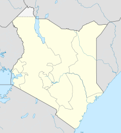

Trans-Nzoia District Politik Provinz Rift Valley Der Trans-Nzoia District ist ein Distrikt in der kenianischen Provinz Rift Valley. Die Hauptstadt des Distriktes ist Kitale. Nur 4,6 % der Haushalte sind an die Stromversorgung angeschlossen.[2] Hauptwirtschaftszweig ist die Landwirtschaft, angebaut wird vor allem Tee und Mais. Der Trans-Nzoia District gehört zur Diözese Kitale der römisch-katholischen Kirche. Von den 575.000 Einwohnern sind knapp 198.000 Menschen katholischen Glaubens.[3] Im Distrikt liegt der kenianische Teil des Mount-Elgon-Nationalparks.
Gliederung
Der Distrikt teilt sich in Councils und Divisionen auf. Es gibt drei Wahlbezirke: Cherangani, Kwanza und Saboti.
Councils Sitz der Behörde Typ Einwohner[2] Kitale Gemeinde 86.055 Nzoia County 489.607 Gesamt - 575.662 Divisionen Division Einwohner Hauptstadt Central 147.992 Kitale Cherangany 52.974 Cherangani Endebess 61.481 Endebess Kaplamai 89.858 Kiminini 64.685 Kiminini Kwanza 88.727 Kwanza Saboti 69.945 Saboti Gesamt 575.662 - Einzelnachweise
- ↑ statoids.com – Districts of Kenya abgerufen am 11. Februar 2010
- ↑ a b Statistik auf cck.go.ke, abgerufen am 7. Februar 2010.
- ↑ Diözese Kitale auf der Homepage der katholischen Kirche in Kenia, abgerufen am 7. Februar 2010.
 Distrikte in Kenia
Central Province: Kiambu | Kirinyaga | Maragua | Murang’a | Nyandarua | Nyeri | Thika
Coast Province: Kilifi | Kwale | Lamu | Malindi | Mombasa | Taita-Taveta | Tana River
Eastern Province: Embu | Isiolo | Kitui | Machakos | Makueni | Marsabit | Mbeere | Meru Central | Meru North | Meru South | Moyale | Mwingi | Tharaka
North-Eastern Province: Garissa | Ijara | Wajir | Mandera
Nyanza Province: Bondo | Gucha | Homa Bay | Kisii Central | Kisumu | Kuria | Migori | Nyamira | Nyando | Rachuonyo | Siaya | Suba
Rift Valley Province: Baringo | Bomet | Buret | Kajiado | Keiyo | Kericho | Koibatek | Laikipia | Marakwet | Nakuru | Nandi | Narok | Samburu | Trans Mara | Trans-Nzoia | Turkana | Uasin Gishu | West Pokot
Western Province: Bungoma | Busia | Butere/Mumias | Kakamega | Lugari | Mount Elgon | Teso | Vihiga
Nairobi: Nairobi
Wikimedia Foundation.
Schlagen Sie auch in anderen Wörterbüchern nach:
Trans-Nzoia (district) — District de Trans Nzoia Le district de Trans Nzoia (en anglais Trans Nzoia District) est un district du Kenya, dans la province de la Vallée du Rift. Il est situé entre la rivière Nzoia et le mont Elgon. C est la terre historique des Kalenjins.… … Wikipédia en Français
Trans-Nzoia District — is an administrative district of Rift Valley Province, Kenya.It is located between the Nzoia River and Mount Elgon and its centre is the town of Kitale.Historically the area has been inhabited by the Kalenjin people. After independence many of… … Wikipedia
Trans Nzoia — District de Trans Nzoia Le district de Trans Nzoia (en anglais Trans Nzoia District) est un district du Kenya, dans la province de la Vallée du Rift. Il est situé entre la rivière Nzoia et le mont Elgon. C est la terre historique des Kalenjins.… … Wikipédia en Français
Trans Mara District — Basisdaten Einwohner Bevölkerungsdichte 170.591 Einw. [1] 60 Einw./km² Fläche 2846 km² Koordinaten … Deutsch Wikipedia
District de Trans-Nzoia — 1° 06′ N 34° 57′ E / 1.1, 34.95 Le district de Trans Nzoia (anglais … Wikipédia en Français
Uasin Gishu District — is one of the seventy one districts of Kenya, located in the Rift Valley Province. The city of Eldoret is its capital, administrative center and commercial center. There is a large population of white immigrants from England, Scotland, South… … Wikipedia
Siaya District — Basisdaten Einwohner Bevölkerungsdichte 480.184 Einw. [1] 316 Einw./km² Fläche 1520 km² Koordinaten … Deutsch Wikipedia
Narok District — is an administrative district in Kenya. The Narok District is located in the Rift Valley Province, and has a population of 365,750. Its capital town is Narok. Along with Kisii District, Narok District has been identified as having the highest… … Wikipedia
Narok District — Basisdaten Einwohner Bevölkerungsdichte 365.750 Einw. [1] 24 Einw./km² Fläche 15.098 km² Koordinaten … Deutsch Wikipedia
Bondo District — Basisdaten Einwohner Bevölkerungsdichte 238.780 Einw. [1] 242 Einw./km² Fläche 987 km² Koordinaten … Deutsch Wikipedia
Trans-Nzoia District

18+
© Academic, 2000-2024
- Kontaktieren Sie uns: Unterstützung, Werbung
Wörterbücher Export, schritte mit PHP, Joomla, Drupal, WordPress, MODx.