- Tampines Expressway
-
Tampines Expressway in Singapur 
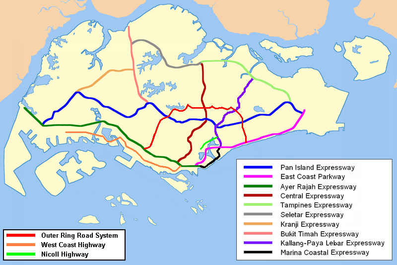
Karte 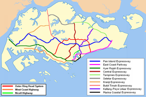
Basisdaten Betreiber: Land Transport Authority Gesamtlänge: 14 km - Seletar
- Sengkang
- Punggol
- Lorong Halus
- Pasir Ris
- Tampines
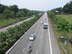
Tampines Expressway von der Abfahrt Jalan Kayu IC. Straßenverlauf
Changi Road East 
(1) Upper Changi IC 
(2) Loyang IC (3ABC) Pasir Ris IC (4) Elias Rd / Tampines Rd (5) Api-Api IC (6-7) Tampines IC 

Halus Bridge (9) Punggol IC (10) Sengkang IC Punggol Bridge (12) Jalan Kayu IC (14) Seletar IC 

Der Tampines Expressway (Abkürzung: TPE, chin.: 淡 滨 尼 高速公路; Pinyin: Dànbīnní Gāosù Gōnglù; malay: Lebuhraya Tampines; Tamil: தெம்பினீஸ் விரைவுச்சாலை) ist eine Autobahn am nord-östlichen Rand von Singapur. Sie beginnt am Pan Island Expressway (PIE) in der Nähe des Singapore Changi Airport im Osten und verläuft dann in nordwestliche Richtung zum Autobahnkreuz mit dem Central Expressway (CTE) und dem Seletar Expressway (SLE) wo sie dann endet.
Stadtteile entlang der Autobahn
- Seletar
- Sengkang
- Punggol
- Lorong Halus
- Pasir Ris
- Tampines
Schlagen Sie auch in anderen Wörterbüchern nach:
Tampines Expressway — Infobox Singapore Expressway routebox length km = km to mi|num=14|abbr=no|spell=Commonwealth|precision=2|wiki=yes direction = West East start/end1 = Yio Chu Kang (CTE, SLE) start/end2 = Tampines (PIE) area = Seletar Sengkang Punggol Lorong Halus… … Wikipedia
Tampines New Town — is a HDB new town located in eastern Singapore. It is bounded by the Tampines Expressway, Tampines Avenue 10, canal north of Bedok Reservoir, Upper Changi Road, Simei Avenue, north of private estate off Upper Changi Road, Simei Road, west of… … Wikipedia
Tampines — SG neighbourhood image englishname=Tampines chinesename=淡滨尼 poj= pengim= pinyin=Dànbīnní malayname=Tampines tamilname=தெம்பினிஸ்Tampines (or Tampines New Town) is the largest residential area in the city state of Singapore and is located in the… … Wikipedia
Tampines — Este artículo o sección necesita referencias que aparezcan en una publicación acreditada, como revistas especializadas, monografías, prensa diaria o páginas de Internet fidedignas. Puedes añadirlas así o avisar … Wikipedia Español
Kallang-Paya Lebar Expressway — Infobox Singapore Expressway routebox length km = km to mi|num=12|abbr=no|spell=Commonwealth|precision=2|wiki=yes direction = Northeast South start/end1 = Tanjong Rhu (ECP, MCE) start/end2 = Lorong Halus (TPE) area = Kallang Paya Lebar construct… … Wikipedia
Marina Coastal Expressway — Route information Length: 5 km (3 mi) Existed: 2008 – present … Wikipedia
North–South Expressway, Singapore — For North–South Expressway in Malaysia, see North–South Expressway, Malaysia. North–South Expressway Route information Length: 21.5 km (13.4 mi) … Wikipedia
Central Expressway, Singapore — Infobox Singapore Expressway routebox name = Central Expressway length km = 15.8km direction = North South start/end1 = Yio Chu Kang (SLE, TPE) start/end2 = Bukit Merah (AYE) area = Seletar Ang Mo Kio Serangoon Gardens Bishan Toa Payoh Central… … Wikipedia
Seletar Expressway — Infobox Singapore Expressway routebox length km = km to mi|num=10.8|abbr=no|spell=Commonwealth|precision=2|wiki=yes direction = West East start/end1 = Kranji (BKE) start/end2 = Yio Chu Kang (CTE, TPE) area = Woodlands Yio Chu Kang construct start … Wikipedia
Seletar Expressway — Vorlage:Infobox hochrangige Straße/Wartung/SG E Seletar Expressway in Singapur Karte … Deutsch Wikipedia
Tampines Expressway


18+
© Academic, 2000-2024
- Kontaktieren Sie uns: Unterstützung, Werbung
Wörterbücher Export, schritte mit PHP, Joomla, Drupal, WordPress, MODx.