Southern Indian Lake

Southern Indian Lake

Photo-request.svg

Bild gesucht 

BW

Geographische Lage Manitoba (Kanada)
Abfluss Churchill River
Orte am Ufer South Indian Lake
Daten
Koordinaten 57° 10′ 0″ N, 98° 29′ 57″ W57.166666666667-98.499166666667254Koordinaten: 57° 10′ 0″ N, 98° 29′ 57″ W
Southern Indian Lake (Manitoba)
Southern Indian Lake
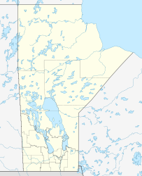
Höhe über Meeresspiegel 254 m
Fläche 2.015 km²[1]

Southern Indian Lake ist ein See in der kanadischen Provinz Manitoba, etwa 300 km westlich der Hudson Bay. Er hat eine Wasserfläche von 2015 km² sowie eine Gesamtfläche mit Inseln von 2247 km².[1] Der See wird vom Churchill River durchflossen und zur Hudson Bay hin entwässert. Die Cree-Siedlung South Indian Lake befindet sich an dessen Südufer.

Einzelnachweise

  1. a b Canadian Resources Canada - The Atlas of Canada - Lakes

Wikimedia Foundation.

Игры ⚽ Поможем сделать НИР

Schlagen Sie auch in anderen Wörterbüchern nach:

  • Indian Lake — may refer to:ongs*Indian Lake (song), a 1968 song by The CowsillsTowns*Indian Lake Township, Minnesota *Indian Lake, New York *Indian Lake, Pennsylvania *Indian Lake, TexasLakes*Indian Lake (Indiana) *Indian Lake (Massachusetts) *Indian Lake, a… …   Wikipedia

  • Lac Southern Indian — Administration Pays  Canada Géographie La …   Wikipédia en Français

  • Lake Manouane — Location La Tuque / Baie Obaoca, Quebec Coordinates 47°33′54″N 74°06′49″W …   Wikipedia

  • Lake Michigan — Landsat …   Wikipedia

  • Indian Navy — crest Active 1947–Present Country …   Wikipedia

  • Lake City, Seattle, Washington — Lake City is the northeast corner of Seattle, centered along Lake City Way NE (SR 522), 7 8 miles (11 13 km) northeast of Downtown. A broader definition of the Lake City area includes all the area between 15th Avenue NE and Lake Washington, and… …   Wikipedia

  • Indian Ocean — This article is about the water body. For the Indian fusion music band, see Indian Ocean (band). The Indian Ocean, not including the Antarctic region. Earth s oceans (World Ocean) …   Wikipedia

  • Lake George (New York) — Infobox lake lake name = Lake George image lake = Lake George 2.jpg caption lake = View from Sabbath Day Point image bathymetry = caption bathymetry = location = Adirondack Mountains coords = coord|43|34|N|73|37|W|type:waterbody region:US… …   Wikipedia

  • Lake George (Anoka County) — Infobox lake lake name = Lake George image lake = caption lake = image bathymetry = LakeGeorge layout.jpg caption bathymetry = map location = Anoka County, Minnesota coords = coord|45|21|25|N|093|20|10|W|type:waterbody… …   Wikipedia

  • Lake Pleasant, New York — Infobox Settlement official name = Lake Pleasant, New York settlement type = Town nickname = motto = imagesize = image caption = image |pushpin pushpin label position = pushpin map caption =Location within the state of New York pushpin mapsize =… …   Wikipedia

Share the article and excerpts

Direct link
Do a right-click on the link above
and select “Copy Link”