Sorell Municipality

Sorell Municipality
Municipality of Sorell
LGA Tas SE Sorell.png
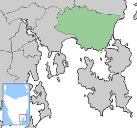
Lage der Sorell Municipality in Tasmanien
Gliederung
Staat: Australien Australien
Bundesstaat: Flag Australia tasmania.png Tasmanien
Verwaltungssitz: Sorell
Daten und Zahlen
Fläche: 583 km²
Einwohner: 11.925 (2006) [1]
Bevölkerungsdichte: 20 Einwohner je km²
-42.783333333333147.56666666667

Die Sorell Municipality ist ein lokales Verwaltungsgebiet (LGA) im australischen Bundesstaat Tasmanien. Das Gebiet ist 583 km² groß und hat etwa 12.000 Einwohner.

Sorell liegt im Südosten der Insel etwa 22 km östlich des Stadtzentrums der Hauptstadt Hobart. Das Gebiet umfasst 20 Ortsteile und Ortschaften: Boomer Bay, Bream Creek, Carlton, Connellys Marsh, Copping, Dodges Ferry, Dunalley, Forcett, Kellevie, Lewisham, Marion Bay, Midway Point, Penna, Primrose Sands, Nugent, Orielton, Pawleena, Sorell, Wattle Hill und White Hills[2]. Der Sitz des Councils befindet sich in der Ortschaft Sorell im Westen der LGA, wo etwa 1500 Einwohner leben.[3]

Verwaltung

Der Sorell Council hat neun Mitglieder. Der Mayor (Bürgermeister), sein Deputy (Stellvertreter) und sieben Councillor werden direkt von den Bewohnern der LGA gewählt. Sorell ist nicht in Bezirke untergliedert.

Quellen

  1. Australian Bureau of Statistics (25. Oktober 2007): Sorell (LGA) (Englisch). 2006 Census QuickStats. Abgerufen am 6. April 2010.
  2. Localities by Council, Local Government Association of Tasmania
  3. Australian Bureau of Statistics (25. Oktober 2007): Sorell (State Suburb) (Englisch). 2006 Census QuickStats. Abgerufen am 23. März 2010.

Weblinks


Wikimedia Foundation.

Игры ⚽ Поможем сделать НИР

Schlagen Sie auch in anderen Wörterbüchern nach:

  • Sorell Council — Infobox Australian Place | type = lga name = Sorell Council state = Tasmania caption = Sorell Council pop = 11,454 (est., June 05) [cite web|url=http://www.abs.gov.au/ausstats/abs@.nsf/Latestproducts/3218.0Main%20Features72004 05?opendocument… …   Wikipedia

  • Mount Sorell (Tasmania) — Infobox Mountain Name = Mount Sorell Photo = Caption = Elevation = Location = West Coast, Tasmania Range = West Coast Range Prominence = Coordinates = coord|42|52|S|145|22|E|type:mountain Topographic First ascent = Easiest route = Mount Sorell is …   Wikipedia

  • Mount Sorell — Location Location West Coast, Tasmania Range …   Wikipedia

  • Latrobe Municipality — Latrobe Lage der Latrobe Municipality in Tasmanien Gliederung …   Deutsch Wikipedia

  • Derwent Valley Municipality — Derwent Valley Lage des Derwent Valley in Tasmanien Gliederung …   Deutsch Wikipedia

  • City of Clarence — Tasmania The City of Clarence Population: 52,935 …   Wikipedia

  • Local Government Areas of Tasmania — Local Government Areas of Tasmania, Australia This article also includes lists of towns, suburbs and localities of Tasmania.Hobart area councilsBrighton Council*Hobart suburbs: **Bridgewater Gagebrook Old Beach *Brighton *Pontville *Tea TreeCity… …   Wikipedia

  • Anthony Fenn Kemp — (1773 – 28 October 1868) was a soldier, merchant and a deputy judge advocate of the colony of New South Wales (now an Australian State). He was one of the key participants in the colony s Rum Rebellion that removed its appointed governor and… …   Wikipedia

  • Kingborough Council — Tasmania Kingborough Council Population: 34 …   Wikipedia

  • City of Glenorchy — Tasmania Population: 44,716 …   Wikipedia

Share the article and excerpts

Direct link
Do a right-click on the link above
and select “Copy Link”