- Sheyenne River
-
Sheyenne River 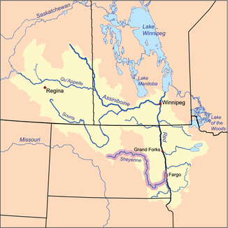
Einzugsgebiet des Red River of the North, Sheyenne River hervorgehoben
Daten Gewässerkennzahl US: 1035146 Lage North Dakota (USA) Flusssystem Nelson River Abfluss über Red River of the North → Winnipegsee → Nelson River → Hudson Bay Quelle 24 km nördlich von McClusky
47° 41′ 46″ N, 100° 29′ 52″ W47.6961108-100.4979113Mündung in den Red River of the North 47.0235771-96.825358260Koordinaten: 47° 1′ 25″ N, 96° 49′ 31″ W
47° 1′ 25″ N, 96° 49′ 31″ W47.0235771-96.825358260Mündungshöhe 260 m[1] Länge 951 km Durchflossene Stauseen Lake Ashtabula 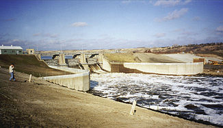
Baldhill Dam am Sheyenne River während dem Frühjahrshochwasser 1996
Der Sheyenne River ist einer der wichtigsten Nebenflüsse des Red River of the North. Er hat eine Länge von etwa 951 km[2] und verläuft im östlichen North Dakota.
Der Fluss hat seinen Ursprung 24 km nördlich von McClusky. Er fließt überwiegend in östlicher Richtung, bevor er nahe McVille seine Richtung nach Süden ändert. Anschließend fließt er durch Griggs County und Barnes County, bevor er sich nahe Lisbon nach Nordosten wendet. Der Fluss wird nördlich von Valley City vom Baldhill Dam zum Lake Ashtabula aufgestaut.
Bei Lisbon durchfließt der Fluss das Sheyenne National Grassland und erreicht Cass County nahe dem Ort Kindred.
Dieser Flussabschnitt ist beliebt bei Kanuten und Outdoor-Enthusiasten. ab Kindred fließt der Fluss in nordnordöstlicher Richtung durch fruchtbare Ebenen des Red River Valley.
Der Charakter des Flusses ändert sich bei Verlassen der sandigen Grasslands. Nun nimmt er fruchtbaren Lehmboden des Red River Valley auf. Früher stellte der Fluss eine Überschwemmungsgefahr für die Städte West Fargo und Harwood dar, in dessen Nähe der Sheyenne River in den Red River of the North mündet. Dank einem Ableitungskanal, der nahe Horace erbaut wurde, überstanden die wichtigsten Städte am Sheyenne River das Hochwasser des Jahres 1997. Es traf jedoch die Städte Grand Forks und East Grand Forks.
Weblinks
Einzelnachweise
- ↑ USGS - Geographic Names Information System
- ↑ U.S. Geological Survey. National Hydrography Dataset high-resolution flowline data. The National Map, accessed June 8, 2011
Kategorien:- Flusssystem Red River of the North
- Fluss in North Dakota
- Fluss in Nordamerika


Wikimedia Foundation.