Rozdrażew

Rozdrażew
Rozdrażew
Wappen von Rozdrażew
Rozdrażew (Polen)
Rozdrażew
Rozdrażew
Basisdaten
Staat: Polen
Woiwodschaft: Großpolen
Landkreis: Krotoszyn
Geographische Lage: 51° 47′ N, 17° 31′ O51.78333333333317.516666666667Koordinaten: 51° 47′ 0″ N, 17° 31′ 0″ O
Einwohner:

1800 (2006)

Postleitzahl: 63-708
Telefonvorwahl: (+48) 62
Kfz-Kennzeichen: PKR
Gemeinde
Gemeindeart: Landgemeinde
Gemeindegliederung: 15 Ortschaften
13 Schulzenämter
Fläche: 79,5 km²
Einwohner:

5138
(31. Dez. 2010) [1]

Bevölkerungsdichte: 65 Einw./km²
Gemeindenummer (GUS): 3012052
Verwaltung (Stand: 2006)
Gemeindevorsteher: Mariusz Jan Dymarski
Adresse: Rynek 3
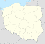
63-708 Rozdrażew
Webpräsenz: www.rozdrazew.pl

Rozdrażew (deutsch Rozdrazewo, 1939–1943 Albertshof, 1943–1945 Brigidau)[2] ist ein Dorf und Sitz der gleichnamigen Landgemeinde in Polen. Der Ort liegt im Powiat Krotoszyński der Wojewodschaft Großpolen.

Gemeinde

Zur Landgemeinde Rozdrażew gehören weitere 13 Ortsteile (deutsche Namen bis 1945) mit einem Schulzenamt.

  • Budy
  • Chwałki
  • Dąbrowa (Dombrowo, 1943–1945 Krotteichen)[2]
  • Dzielice (Dzielice, 1943–1945 Herrenberg (Kr. Krotoschin))[2]
  • Grębów
  • Henryków (Heinrichsfeld, 1943–1945 Heinrichsfeld (Kr. Krotoschin))[2]
  • Maciejew (Maciejewo, 1943–1945 Rübenfeld)[2]
  • Nowa Wieś (Neudorf, 1943–1945 Budenneudorf)[2]
  • Rozdrażew (Rozdrazewo, 1939–1943 Albertshof, 1943–1945 Brigidau)[2]
  • Trzemeszno (Trzemeszno, 1943–1945 Tremsen)[2]
  • Wolenice (Wolenice, 1943–1945 Wollnitz)[2]
  • Wyki (Wykow, 1943–1945 Tripshuben)[2]

Weitere Ortschaften der Gemeinde sind Dębowiec und Wygoda.

Weblinks

Fußnoten

  1. Population. Size and Structure by Territorial Division. As of December 31, 2010. Główny Urząd Statystyczny (GUS), abgerufen am 23. Juni 2011.
  2. a b c d e f g h i j Vgl. Weblink "Anordnung über Ortsnamenänderung im Reichsgau Wartheland" - Landkreis Krotoschin

Wikimedia Foundation.

Игры ⚽ Нужен реферат?

Schlagen Sie auch in anderen Wörterbüchern nach:

  • Rozdrazew — Original name in latin Rozdraew Name in other language State code PL Continent/City Europe/Warsaw longitude 51.78218 latitude 17.50491 altitude 143 Population 1800 Date 2010 10 05 …   Cities with a population over 1000 database

  • Gmina Rozdrażew — Infobox Settlement name = Gmina Rozdrażew other name = Rozdrażew Commune settlement type = Gmina total type = Total image shield = image shield = subdivision type = Country subdivision name = POL subdivision type1 = Voivodeship subdivision name1 …   Wikipedia

  • Dąbrowa, Gmina Rozdrażew — For other places with the same name, see Dąbrowa (disambiguation). Dąbrowa   Village   Country Poland …   Wikipedia

  • Nowa Wieś, Krotoszyn County — For other places with the same name, see Nowa Wieś (disambiguation). Nowa Wieś   Village   …   Wikipedia

  • Гмина Роздражев — Gmina Rozdrażew Страна:  Польша Повят:  Кротошинский повят Глава:  Марюш Ян Дымарски (2006) Площадь:  79,47 км² Население:  5164 чел. Год переписи:  2004 Плотность …   Википедия

  • Chwałki, Greater Poland Voivodeship — See also: Chwałki, Świętokrzyskie Voivodeship Chwałki   Village   Country Poland …   Wikipedia

  • Гмины Великопольского воеводства —     …   Википедия

  • Роздражев (гмина) — Гмина Роздражев Gmina Rozdrażew Герб …   Википедия

  • Dąbrowa — is a Polish name for an oak forest. It appears in many Polish toponyms, including three towns and 86 villages. It is also referenced in the Dąbrowa coat of arms. Towns and villages named Dąbrowa include: Dąbrowa Białostocka, a town in Podlasie… …   Wikipedia

  • Krotoszyn County — Infobox Settlement name = Krotoszyn County native name = Powiat krotoszyński settlement type = image shield = POL powiat krotoszyński COA.svg map caption = Location within the voivodeship subdivision type = Country subdivision name = POL… …   Wikipedia

Share the article and excerpts

Direct link
Do a right-click on the link above
and select “Copy Link”