Roebourne Shire

Roebourne Shire
Shire of Roebourne
Roebourne LGA WA.png
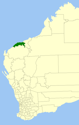
Lage des Roebourne Shire in Westaustralien
Gliederung
Staat: Australien Australien
Bundesstaat: Flag of Western Australia.svg Western Australia
Verwaltungssitz: Karratha
Daten und Zahlen
Fläche: 15.234 km²
Einwohner: 16.423 (2006) [1]
Bevölkerungsdichte: 1,1 Einwohner je km²
Wards: 4
-20.733333333333116.83333333333

Das Shire of Roebourne ist ein lokales Verwaltungsgebiet (LGA) in der Region Pilbara im australischen Bundesstaat Western Australia. Das Gebiet ist 15.234 km² groß und hat etwa 16.500 Einwohner.

Roebourne liegt an der Nordwestküste des Staats etwa 1250 km nördlich der Hauptstadt Perth. Der Sitz des Shire Councils befindet sich in der Stadt Karratha, wo etwa 11.700 Einwohner leben[2].

Verwaltung

Der Roebourne Council hat elf Mitglieder. Die Councillor werden von den Bewohnern der vier Wards (sechs aus dem Karratha Ward, je zwei aus dem Wickham/Point Samson/Cossack und aus dem Dampier und einer aus dem Roebourne/Pastoral Ward) gewählt. Aus dem Kreis der Councillor rekrutiert sich auch der Ratsvorsitzende und Shire President.

Quellen

  1. Australian Bureau of Statistics (25. Oktober 2007): Roebourne (S) (Local Government Area) (Englisch). 2006 Census QuickStats. Abgerufen am 24. Juli 2010.
  2. Australian Bureau of Statistics (25. Oktober 2007): Karratha (Urban Centre/Locality) (Englisch). 2006 Census QuickStats. Abgerufen am 24. Juli 2010.

Weblinks


Wikimedia Foundation.

Игры ⚽ Поможем сделать НИР

Schlagen Sie auch in anderen Wörterbüchern nach:

  • Shire of Roebourne — Infobox Australian Place | type = lga name = Shire of Roebourne state = wa imagesize= 180 caption = Location in Western Australia pop = 16,423 (2006 census) area = 15234 est = 1910 seat = Karratha mayor = Brad Snell region = Pilbara url =… …   Wikipedia

  • Roebourne — Staat: Australien Bundesstaat …   Deutsch Wikipedia

  • Shire of Murchison — Western Australia Location in Western Australia Population …   Wikipedia

  • Shire of Derby-West Kimberley — Western Australia Population: 7,9 …   Wikipedia

  • Shire of Christmas Island — Population: 1,440(2009)[1] …   Wikipedia

  • Shire of Ngaanyatjarraku — Western Australia Location in Western Australia Population …   Wikipedia

  • Roebourne, Western Australia — Infobox Australian Place | type = town name = Roebourne state = wa caption = Roebourne Tourist Centre lga = Shire of Roebourne postcode = 6718 pop = 950 est = 1880s stategov = North West fedgov = Kalgoorlie dist1 = 202 location1= Port Hedland… …   Wikipedia

  • Shire of Murray — This article is about the Western Australian Shire of Murray. For the New South Wales shire, see Murray Shire. Shire of Murray Western Australia Location in …   Wikipedia

  • Shire of Ashburton — Infobox Australian Place | type = lga name = Shire of Ashburton state = wa imagesize= 180 caption = Location in Western Australia pop = 6,078 (2006 census) area = 101240 est = 1972 seat = Tom Price mayor = Leanne Corker region = Pilbara url =… …   Wikipedia

  • Shire of Donnybrook-Balingup — This article is about a local government area. For the town, see Donnybrook, Western Australia. Shire of Donnybrook Balingup Western Australia …   Wikipedia

Share the article and excerpts

Direct link
Do a right-click on the link above
and select “Copy Link”