- Rannoch Moor
-
 Das Rannoch Moor von der A82 fotografiert
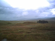 Das Rannoch Moor vom West Highland Way fotografiert
Das Rannoch Moor (schottisch-gälisch: Mòinteach Raineach) ist ein circa 130 km² großes Moor in den schottischen Highlands. Es liegt in den Unitary Authorities Highland, Perth and Kinross und zu einem kleinen Teil im Norden von Argyll and Bute.
Beschreibung
Das Rannoch Moor befindet sich auf einem 300 bis 400 Meter über dem Meeresspiegel liegenden Plateau und ist weitgehend unbewohnt. Es hat – grob gesehen – eine dreieckige Form. Die östliche Ecke des Dreiecks wird durch das westliche Ufer des Loch Rannoch markiert. Als Südspitze des Rannoch Moors gilt allgemein Loch Tulla. Die westliche Ecke befindet sich am östlichen Ausgang des Tales Glen Coe.
Das Rannoch Moor ist für die Landwirtschaft gänzlich ungeeignet und daher eine der letzten von Menschenhand unberührten Landschaften Schottlands. Das Gebiet ist durch unzählige Torfsümpfe, Wasserläufe, Tümpel und Seen geprägt. Die größte Wasserfläche im Moor ist das Blackwater Reservoir, ein um 1900 angelegten Stausee. Die größten natürlichen Wasserflächen sind Loch Laidon, Loch Eigheach und Loch Bà. Umgegeben ist das Moor von zahlreichen, bis zu 1000 m hohen Bergen. Das Rannoch Moor ist eine Wasserscheide. Die westlich gelegegen Seen und Flüsse entwässern letztlich in den Atlantik, die östlichen über den River Tay in die Nordsee.
Das Rannoch Moor wird nur in Nord-Süd-Richtung von der A82 und einer Eisenbahnlinie erschlossen. Eine Straßen- beziehungsweise Eisenbahnverbindung in Ost-West-Richtung existiert nicht. Auch der West Highland Way, ein 153 km langer Fernwanderweg, durchquert das Gebiet von Süden nach Norden.
Trivia
- Es gibt einige Donald-Duck-Comics, in denen das fiktionale McDuck Castle eine Rolle spielt. Das Schloss soll gemäß der Comics an einem Ort namens Dismal Downs im Rannoch Moor liegen.
- Im britischen Film Trainspotting (1996) fahren die drogenabhängigen Protagonisten der Handlung aufs Land, um eine kleine Wanderung zu unternehmen. Die Szene wurde an der Corrour Rail Station im Rannoch Moor gedreht.
Weblinks
 Commons: Rannoch Moor – Sammlung von Bildern, Videos und Audiodateien
- Beschreibung des Moors (en.)
- Beschreibung des Moors (en.)
- Informationen für Wanderer (de.)
56.666666666667-4.75Koordinaten: 56° 40′ 0″ N, 4° 45′ 0″ WKategorien:- Geographie (Highland)
- Geographie (Perth and Kinross)
- Geographie (Argyll and Bute)
- Flusssystem Tay


Wikimedia Foundation.