Quesnel River

Quesnel River
Quesnel RiverVorlage:Infobox Fluss/GKZ_fehlt
Lage British Columbia (Kanada)
Flusssystem Fraser River
Abfluss über Fraser River → Pazifischer Ozean
Quelle Quesnel Lake bei Likely
52° 36′ 55″ N, 121° 34′ 23″ W52.615277777778-121.57305555556729
Quellhöhe 729 mVorlage:Infobox Fluss/NACHWEISE_fehlen
Mündung Fraser River bei Quesnel
52.97-122.49888888889469

52° 58′ 12″ N, 122° 29′ 56″ W52.97-122.49888888889469
Mündungshöhe 469 mVorlage:Infobox Fluss/NACHWEISE_fehlen
Höhenunterschied 260 m
Länge 203 km[1]
Einzugsgebiet 12.000 km²[1]

Vorlage:Infobox Fluss/ABFLUSS_fehlt

Rechte Nebenflüsse Cariboo River, Mitchell River
Kleinstädte Quesnel
Gemeinden LikelyVorlage:Infobox Fluss/BILD_fehlt
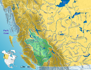
Fraser River Watershed
Mule train at the Quesnel River 1868

Der Quesnel River ist einer der größeren Nebenflüsse des Fraser River im Cariboo Regional District von Zentral-British Columbia.[2] Er verlässt den See Quesnel Lake bei dem Ort Likely und fließt etwa 100 km in nordwestlicher Richtung bis zu seiner Mündung in den Fraser bei der Stadt Quesnel. Die Gesamtlänge des Quesnel River gemessen vom hinteren Ende des Quesnel Lake beträgt 203 km.[1] Der Zufluss Mitchell River mündet in den nordöstlichen Arm des Quesnel Lake.

Geschichte

Etwas unterhalb des Ausflusses aus dem Quesnel Lake, am Zusammenfluss mit dem Cariboo River, liegt die historisch bedeutende Geisterstadt Quesnel Forks, aka "the Forks". Zahlreiche Routen zu den Goldminen des Cariboo-Goldrausch lagen nördlich von Quesnel Forks im Einzugsgebiet des Cottonwood River.

Der Fluss wurde nach Jules-Maurice Quesnel, der gemeinsam mit Simon Fraser in den frühen Jahren des 19. Jahrhunderts die Gegend erkundete, benannt.

Siehe auch

  • Big Canyon
  • Little Canyon

Einzelnachweise

  1. a b c The Atlas of Canada - Rivers
  2. Quesnel River. In: BC Geographical Names Information System.

Wikimedia Foundation.

Игры ⚽ Поможем написать курсовую

Schlagen Sie auch in anderen Wörterbüchern nach:

  • Quesnel River — Geobox|River name = Quesnel River native name = other name = category = etymology = nickname = image caption = country = Canada country state type = Province state = British Columbia region = district = municipality = parent = tributary left =… …   Wikipedia

  • Mitchell River (Quesnel River) — For the other river named Mitchell River in BC, see Mitchell River (Cross River). Coordinates: 52°47′00″N 120°49′00″W / 52.7833333°N 120.8166667°W …   Wikipedia

  • Quesnel (British Columbia) — Quesnel Lage in British Columbia …   Deutsch Wikipedia

  • Quesnel (Colombie-Britannique) — Quesnel Administration Pays  Canada Province …   Wikipédia en Français

  • Quesnel — or Quesnell may refer to:Places* Quesnel, British Columbia * Quesnel Forks, British Columbia * Quesnell, AlbertaGeographical features* Quesnel Lake * Quesnel River * Quesnel HighlandPeople* Chantal Quesnel * Frédéric Auguste Quesnel * Joseph… …   Wikipedia

  • Quesnel Lake — Infobox lake lake name = Quesnel Lake image lake = Quesnel Lake.gif caption lake = image bathymetry = caption bathymetry = coords = coord|52.536273|N|121.04187|W|type:waterbody region:CA BC|display=inline,title type = glacial, fjord lake,… …   Wikipedia

  • Quesnel, British Columbia — Infobox Settlement official name = Pagename other name = native name = nickname = settlement type = motto = In Situ imagesize = image caption = flag size = image seal size = image shield = shield size = city logo = citylogo size = mapsize = map… …   Wikipedia

  • Quesnel (sternwheeler) — The Quesnel sternwheeler was first launched in May 1909 at Quesnel to serve the Soda Creek to Fort George route of the upper Fraser River.cite book |last=West |first=Willis|title=Stagecoach and Sternwheel Days in the Cariboo and Central… …   Wikipedia

  • Quesnel Highland — The boundary of the Quesnel Highland is not precisely defined in Holland, and in some interpretations it may be considered to be part of the Interior Plateau, as Holland defines it, or as a subrange of the Cariboo Mountains. Those mountains also …   Wikipedia

  • Quesnel — ▪ British Columbia, Canada       town, south central British Columbia, Canada. It lies at the confluence of the Quesnel and Fraser rivers, 411 miles (661 km) north of Vancouver. The river and town site (Quesnellemouth until 1864) were named for… …   Universalium

Share the article and excerpts

Direct link
Do a right-click on the link above
and select “Copy Link”