Peppermint Grove Shire

Peppermint Grove Shire
Shire of Peppermint Grove
Peppermint Grove LGA WA.png
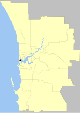
Lage des Peppermint Grove Shire in Westaustralien
Gliederung
Staat: Australien Australien
Bundesstaat: Flag of Western Australia.svg Western Australia
Verwaltungssitz: Peppermint Grove
Daten und Zahlen
Fläche: 1,1 km²
Einwohner: 1.580 (2006) [1]
Bevölkerungsdichte: 1.436 Einwohner je km²
-32115.76666666667

Das Shire of Peppermint Grove ist ein lokales Verwaltungsgebiet (LGA) im australischen Bundesstaat Western Australia. Peppermint Grove gehört zur Metropole Perth, der Hauptstadt von Western Australia. Das Gebiet hat etwa 1600 Einwohner und ist mit einer Fläche von 1,1 km² die kleinste LGA Australiens.

Peppermint Grove liegt am Nordufer des Swan River nahe der Mündung etwa 10 km südwestlich des Stadtzentrums und besteht nur aus dem gleichnamigen Stadtteil.

Verwaltung

Der Peppermint Grove Council hat sieben Mitglieder. Sie werden von allen Bewohnern der LGA gewählt. Peppermint Grove ist nicht in Bezirke unterteilt. Aus dem Kreis der Councillor rekrutiert sich auch der Ratsvorsitzende und President des Shires.

Quellen

  1. Australian Bureau of Statistics (25. Oktober 2007): Peppermint Grove (S) (Local Government Area) (Englisch). 2006 Census QuickStats. Abgerufen am 24. Juli 2010.

Weblinks


Wikimedia Foundation.

Игры ⚽ Нужно сделать НИР?

Schlagen Sie auch in anderen Wörterbüchern nach:

  • Peppermint Grove, Western Australia — Infobox Australian Place | type = suburb name = Peppermint Grove city = Perth state = wa caption = Grove of Peppermint trees overlooking Freshwater Bay on the Swan River lga = Shire of Peppermint Grove area = 1.1 postcode = 6011 pop = 1,580 (2006 …   Wikipedia

  • Shire of Peppermint Grove — Infobox Australian Place | type = lga name =Shire of Peppermint Grove state =wa imagesize =200 region =West Metropolitan Perth est =1895 area =1.1 seat =Peppermint Grove pop =1,580 (2006 census) logo = url =http://www.peppermintgrove.wa.gov.au… …   Wikipedia

  • Shire of Murchison — Western Australia Location in Western Australia Population …   Wikipedia

  • Shire of Derby-West Kimberley — Western Australia Population: 7,9 …   Wikipedia

  • Shire of Christmas Island — Population: 1,440(2009)[1] …   Wikipedia

  • Shire of Ngaanyatjarraku — Western Australia Location in Western Australia Population …   Wikipedia

  • Shire of Murray — This article is about the Western Australian Shire of Murray. For the New South Wales shire, see Murray Shire. Shire of Murray Western Australia Location in …   Wikipedia

  • Shire of Donnybrook-Balingup — This article is about a local government area. For the town, see Donnybrook, Western Australia. Shire of Donnybrook Balingup Western Australia …   Wikipedia

  • Shire of Mount Marshall — Mount Marshall redirects here. For other uses, see Mount Marshall (New York) and Mount Marshall (Antarctica). Shire of Mount Marshall Western Australia …   Wikipedia

  • Shire of Capel — Infobox Australian Place | type = lga name = Shire of Capel state = wa imagesize= 180 caption = Location in Western Australia pop = 10,206 (2006 census) area = 557.6 est = 1894 seat = Capel mayor = Murray Scott region = South West url =… …   Wikipedia

Share the article and excerpts

Direct link
Do a right-click on the link above
and select “Copy Link”