Palisades (New York)

Palisades (New York)
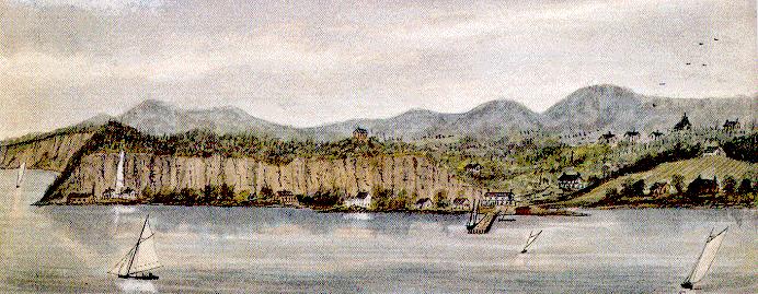
Sneden’s Landing von Robert Knox Sneden, 1858

Palisades ist ein Ortsteil der Stadt Orangetown Rockland County, New York, Vereinigte Staaten.

Er war früher als Sneden’s Landing und dann als Rockland bekannt und liegt nördlich von Rockleigh und Alpine, New Jersey; östlich von Tappan; südlich von Sparkill und westlich des Hudson River. Zurzeit hat Palisades keinen Bürgermeister, noch hat jeder Beamte legislative Stellen. Es hat jedoch eine eigene Bibliothek, und die Post mit der Postleitzahl 10964. Es gibt fast nur Wohngebiete mit Ausnahme eines kleinen Industriegebiets Abschnittes an der Grenze zu Tappan. Das Gebiet ist allgemein bekannt als Snedens Landing und es liegt im östlichen Teil von Palisades zwischen US Highway 9W und den Hudson River. Der Weiler hat eine eingetragene historische Viertel wie die Closter Road – Oak Tree Road Historic District. Der Bezirk umfasst das Gebiet von der Nordseite des Closter Road und Südseite des Oak Tree Road ca. halbe Meile westlich von US Highway 9W in Palisades. (Liste der Registered Historic Places in Rockland County, New York). Auch bedeutend ist das Lamont-Doherty Earth Observatory (von der Columbia University). Sneden's Landing wird in Alec Wilders Song „Did You Ever Cross Over zu Sneden’s?“ erwähnt.

Tourismus

Historische Stätten

  • Skunk Hollow – (Nord-Eingang der Lamont-Doherty Earth Observatory) Route 9W.
  • Cliffside (Palisades, New York) (NRHP)
  • Closter Road-Oak Tree Road Historic District – (NRHP)
  • Washington Spring Road-Woods Road Historic District – (NRHP)

Interessante Orte

  • Abner Concklin House. (NRHP)
  • Big House. (NRHP)
  • Haring-Eberle House. (NRHP)
  • Little House. (NRHP)
  • Neiderhurst. (NRHP)
  • Seven Oaks Estate. (NRHP)


41.011207-73.913469

Wikimedia Foundation.

Игры ⚽ Нужен реферат?

Schlagen Sie auch in anderen Wörterbüchern nach:

  • Palisades, New York — Palisades, formerly known as Sneden s Landing and then Rockland, is a hamlet in the Town of Orangetown Rockland County, New York, United States located north of Rockleigh and Alpine, New Jersey; east of Tappan; south of Sparkill and west of the… …   Wikipedia

  • Cliffside (Palisades, New York) — Cliffside U.S. National Register of Historic Places …   Wikipedia

  • Little House (Palisades, New York) — Infobox nrhp | name =Little House nrhp type = caption = location= US 9W N of Oak Tree Rd., Palisades, New York lat degrees = 41 lat minutes = 0 lat seconds = 43 lat direction = N long degrees = 73 long minutes = 54 long seconds = 45 long… …   Wikipedia

  • New York metropolitan area — New York Newark Bridgeport New York New Jersey Connecticut Pennsylvania Combined Statistical Area (CSA)   Tri State Area   …   Wikipedia

  • New City, New York —   CDP   …   Wikipedia

  • New York Tunnel Extension — Pennsylvania Railroad Tunnel under the Hudson River, New York City Overview Type …   Wikipedia

  • New York State Department of Environmental Conservation — DEC logo Agency overview Formed April 22, 1970 Preceding agencies New York State Conservation Department New York State Conservation Commission New York State Forest …   Wikipedia

  • New York State Park Police — Abbreviation NYSPP Patch of the New York State Park Police …   Wikipedia

  • New York Metropolitan Area — Die New York Metropolitan Area, auch Tri States Area oder Tri States Region (= Drei Staaten Region) genannt, ist die Metropolregion rund um New York City. Sie ist die einwohnermäßig größte Metropolregion der Vereinigten Staaten und die… …   Deutsch Wikipedia

  • New York State Route 59 — NYS Route 59 Korean War Veterans Memorial Highway Map of Rockland County with NY 59 highlighted in red …   Wikipedia

Share the article and excerpts

Direct link
Do a right-click on the link above
and select “Copy Link”