- Obrzycko
-
Obrzycko 
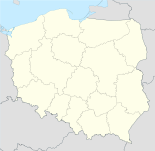

Obrzycko Basisdaten Staat: Polen Woiwodschaft: Großpolen Landkreis: Szamotuły Fläche: 3,74 km² Geographische Lage: 52° 42′ N, 16° 32′ O52.70638888888916.529166666667Koordinaten: 52° 42′ 23″ N, 16° 31′ 45″ O Einwohner: 2262
(31. Dez. 2010)[1]Postleitzahl: 64-520 Telefonvorwahl: (+48) 61 Kfz-Kennzeichen: PSZ Gemeinde Gemeindeart: Landgemeinde Gemeindegliederung: 22 Ortschaften 11 Schulzenämter Fläche: 110,7 km² Einwohner: 2262
(31. Dez. 2010) [2]Bevölkerungsdichte: 20 Einw./km² Gemeindenummer (GUS): 3024011 Verwaltung (Stand: 2011) Gemeindevorsteher: Maciej Bieniek Adresse: Rynek 19
64-520 ObrzyckoWebpräsenz: www.obrzycko.com Obrzycko (deutsch Obersitzko, 1943–1945 Obersitz)[3] ist eine Stadt und Sitz der Stadtgemeinde und einer gleichnamigen Landgemeinde in Polen zu der die Stadt nicht gehört. Der Ort liegt im Powiat Szamotulski der Wojewodschaft Großpolen.
Inhaltsverzeichnis
Gemeinde
Zur Landgemeinde Obrzycko gehören weitere 11 Ortsteile (deutsche Namen bis 1945)[4] mit einem Schulzenamt. Die Landgemeinde hat 4372 Einwohner.[5]
Weitere Ortschaften der Gemeinde sind:
- Karolin
- Brączewo
- Daniele
- Lizbona
- Bugaj
- Annogóra
- Antoniny
- Modrak
- Nowina
- Słopanowo-Huby
- Karczemka
- Chraplewo
Söhne und Töchter der Stadt
- Otto Eduard Hasse (1903–1978), deutscher Schauspieler, Regisseur und Synchronsprecher
Verweise
Weblinks
 Commons: Obrzycko – Album mit Bildern und/oder Videos und Audiodateien
Fußnoten
- ↑ Population. Size and Structure by Territorial Division. As of December 31, 2010. Główny Urząd Statystyczny (GUS), abgerufen am 23. Juni 2011.
- ↑ Population. Size and Structure by Territorial Division. As of December 31, 2010. Główny Urząd Statystyczny (GUS), abgerufen am 23. Juni 2011.
- ↑ a b c Anordnung über Ortsnamenänderung im Reichsgau Wartheland im Verordnungsblatt des Reichstatthalters im Warthegau vom 18. Mai 1943 (pdf)
- ↑ a b c d e f g h i Vgl. Forum Ahnenforschung - deutsche Ortsnamen im Wartheland
- ↑ Główny Urząd Statystyczny, „LUDNOŚĆ – STAN I STRUKTURA W PRZEKROJU TERYTORIALNYM“, Stand vom 30. Juni 2010 (WebCite)
Kategorien:- Gmina in der Woiwodschaft Großpolen
- Ort der Woiwodschaft Großpolen


Wikimedia Foundation.