Oaky River Lake

Oaky River Lake
Oaky River Lake
Oaky River Lake (rechts) mit Oaky River und Oaky River Gorge (links)
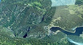
Zuflüsse: Oaky River
Abflüsse: Oaky River
Größere Städte in der Nähe: Armidale, Wollomombi, Jeogla
Oaky River Lake (New South Wales)
Oaky River Lake
Koordinaten 30° 34′ 7,1″ S, 152° 4′ 44,8″ O-30.56865241152.0791194Koordinaten: 30° 34′ 7,1″ S, 152° 4′ 44,8″ O
Daten zum Bauwerk
Daten zum Stausee
Höhe des Stauziels: 891 m
Wasseroberfläche bei Vollstau: 42 ha
Stauseelänge: 3,8 km
Stauseebreite: 300 m
Speicherraum: 2.780 m³

Das Oaky River Lake ist ein Stausee im Nordosten des australischen Bundesstaates New South Wales. Er ist einer von drei künstlichen Seen im Einzugsbereich des Macleay River.

Der See liegt am Oaky River, 40 km östlich von Armidale, östlich der Verbindungsstraße Armidale–Kempsey und südlich der Verbindungsstraße Armidale–Grafton. Nur der Oaky River speist den Stausee.

Weblinks und Quellen


Wikimedia Foundation.

Игры ⚽ Нужен реферат?

Schlagen Sie auch in anderen Wörterbüchern nach:

  • Oaky River — Lake und Oaky River Gorge mit Oaky RiverVorlage:Infobox Fluss/KARTE fehlt …   Deutsch Wikipedia

  • Boyne River (Korallenmeer) — Boyne River Lake Awoonga am Boyne RiverVorlage:Infobox Fluss/KARTE fehlt …   Deutsch Wikipedia

  • Burdekin River — Blick von der Burdekin Bridge auf den FlussVorlage:Infobox Fluss/KARTE fehlt Daten …   Deutsch Wikipedia

  • Murrumbidgee River — im Murray Darling System DatenVorlage …   Deutsch Wikipedia

  • Burnett River — in der Nähe von BundabergVorlage:Infobox Fluss/KARTE fehlt …   Deutsch Wikipedia

  • Nogo River — Nogo RiverVorlage:Infobox Fluss/GKZ fehlt Lage Queensland (Australien) Flusssystem Burnett River Abfluss über Burnett River → Kora …   Deutsch Wikipedia

  • Connors River — Connors RiverVorlage:Infobox Fluss/GKZ fehlt Lage Queensland (Australien) Flusssystem Fitzroy River Abfluss über Isaac River → Ma …   Deutsch Wikipedia

  • Cockle Creek Power Station — Country Australia Location Teralba, New South Wales Status Decommissioned Commission date 11 March 1927 Decommission date March 1976 …   Wikipedia

  • Rivers of New South Wales — Thunderbolts Way and the bridge over the Little Manning River. This page discusses the rivers and hydrography of the State of New South Wales, Australia. The principal topographic feature of New South Wales is the series of low highlands and… …   Wikipedia

  • Munmorah Power Station — is a coal fired power station on the shores of Lake Munmorah. It has two steam turbines that generate a total capacity of 600.01 MW of electricity. The station was originally built with four English Electric 350 MW turbo alternators, and had a… …   Wikipedia

Share the article and excerpts

Direct link
Do a right-click on the link above
and select “Copy Link”