- Chelmsford (Borough)
-
Borough of Chelmsford 
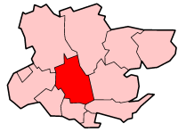
Lage in EssexStatus District Region East of England Verw.grafschaft Essex Verwaltungssitz Chelmsford Fläche 342,24 km² (141.) Einwohner 164.500 (95.) ONS-Code 22UF Website www.chelmsford.gov.uk Chelmsford ist ein Verwaltungsbezirk mit dem Status eines Borough in der Grafschaft Essex in England. Größte Stadt und Verwaltungssitz sowohl des Borough als auch der Grafschaft ist Chelmsford.
Der Bezirk wurde am 1. April 1974 gebildet und entstand aus der Fusion der Stadt Chelmsford mit dem größten Teil des Rural District Chelmsford.
Orte im Borough
- Chelmsford
- Great Baddow
- Great Oxney Green
- Pleshey
- Writtle

Basildon | Braintree | Brentwood | Castle Point | Chelmsford | Colchester | Epping Forest | Harlow | Maldon | Rochford | Tendring | Uttlesford
Wikimedia Foundation.
Schlagen Sie auch in anderen Wörterbüchern nach:
Chelmsford (borough) — Borough of Chelmsford Non metropolitan district, Borough Chelmsford shown within Essex … Wikipedia
Chelmsford local elections — Chelmsford District Council in Essex, England is elected every four years. Since the last boundary changes in 2003 57 councillors have been elected from 24 wards.[1][2] Contents 1 Political control … Wikipedia
Chelmsford (UK Parliament constituency) — Chelmsford Borough constituency for the House of Commons Boundary of Chelmsford in Essex … Wikipedia
Chelmsford Hockey Club — League English Hockey League Founded 1898 History The Grove Lawn Tennis Club was foun … Wikipedia
Chelmsford Museums — consists of Chelmsford Museum, the Essex Regimental Museum and the industrial and science collections at Sandford Mill. Contents 1 Chelmsford Museum 2 Locations 3 References 4 External link … Wikipedia
Chelmsford (disambiguation) — Chelmsford may refer to: Chelmsford the county town of Essex, England Chelmsford (borough), England Chelmsford City F.C., a football club in the above town. Chelmsford railway station, a railway station in the above town. Chelmsford 123, a sitcom … Wikipedia
Chelmsford — For other uses, see Chelmsford (disambiguation). Coordinates: 51°44′10″N 0°28′47″E / 51.7361°N 0.4798°E / 51.7361; 0.4798 … Wikipedia
Chelmsford — 51.7344444444440.47277777777776 Koordinaten: 51° 44′ N, 0° 28′ O … Deutsch Wikipedia
Chelmsford Rural District — Chelmsford Geography Status Rural district 1911 area 83,045 acres (336 km2) 1961 area 86,505 acres (350 km2) HQ … Wikipedia
Chelmsford City F.C. — Chelmsford City Full name Chelmsford City Football Club Nickname(s) The Clarets Founded 1878 (Chelmsford) 1938 (Chelmsford City) … Wikipedia
Chelmsford (Borough)

18+
© Academic, 2000-2024
- Kontaktieren Sie uns: Unterstützung, Werbung
Wörterbücher Export, schritte mit PHP, Joomla, Drupal, WordPress, MODx.