Murray Shire (New South Wales)

Murray Shire (New South Wales)
Shire of Murray
Australia-Map-NSW-LGA-Murray.png
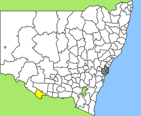
Lage des Murray Shire in New South Wales
Gliederung
Staat: Australien Australien
Bundesstaat: Flag of New South Wales.svg New South Wales
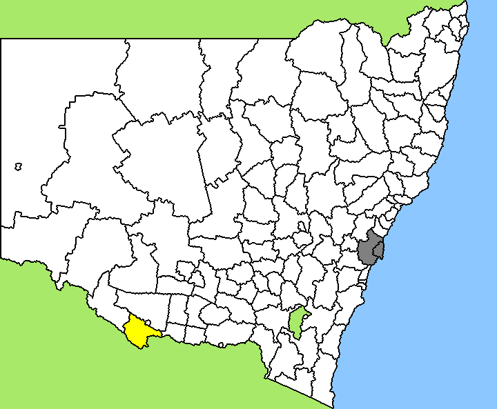
Verwaltungssitz: Mathoura
Daten und Zahlen
Fläche: 4.345 km²
Einwohner: 6.417 (2006) [1]
Bevölkerungsdichte: 1,5 Einwohner je km²
-35.65144.61666666667

Murray Shire ist ein lokales Verwaltungsgebiet (LGA) im australischen Bundesstaat New South Wales. Das Gebiet ist 4.345 km² groß und hat etwa 6.400 Einwohner.

Murray liegt etwa auf halber Länge der Südgrenze des Staates nördlich des Murray River etwa 570 km westlich der australischen Hauptstadt Canberra und 260 km nördlich der Metropole Melbourne. Das Gebiet umfasst 33 Ortsteile und Ortschaften: Barmah, Barnes, Brassi, Bullatale, Bunnaloo, Caldwell, Calimo, Cornalla, Cummeragunja, Gulpa, Hill Plain, Maloga, Mathoura, Moama, Moira, Moonahcullah, Old Cobram, Peeroo, Perricoota, Picnic Point, Stevens Weir, Tantonan, Tarragon, tataila, Thyra, Tumudeery, Walliston, Warbreccan, Werai, Womboota und Yallakool sowie Teile von Deniliquin und Thule. Der Sitz des Shire Councils befindet sich am Ostrand der LGA in Mathoura, wo etwa 650 Einwohner leben.

Verwaltung

Der Murray Shire Council hat neun Mitglieder, die von den Bewohnern der LGA gewählt werden. Murray ist nicht in Bezirke untergliedert. Aus dem Kreis der Councillor rekrutiert sich auch der Mayor (Bürgermeister) des Councils.

Weblinks

Einzelnachweise

  1. Australian Bureau of Statistics (25. Oktober 2007): Murray (A) (Local Government Area) (Englisch). 2006 Census QuickStats. Abgerufen am 6. April 2010.

Wikimedia Foundation.

Игры ⚽ Нужно сделать НИР?

Schlagen Sie auch in anderen Wörterbüchern nach:

  • Murray County, New South Wales — Map of all coordinates from Google Map of all coordinates from Bing Export all coordinates as KML …   Wikipedia

  • New England (New South Wales) — New England New South Wales Mount Duval in New England Population …   Wikipedia

  • Regions of New South Wales — In the State of New South Wales, Australia, there are many areas which are commonly known by regional names. Regions are areas that share similar characteristics. These characteristics may be natural such as the Murray River, the coastline, or… …   Wikipedia

  • South West Slopes (New South Wales) — The South West Slopes is a region predominantly in New South Wales, Australia. It covers the lower inland slopes of the Great Dividing Range extending from north of Cowra through southern NSW into western Victoria. More than 90% of the region is… …   Wikipedia

  • New South Wales state election campaign, 2007 — Main article: New South Wales state election, 2007 Election campaign, 2007 Government Opposition Labor …   Wikipedia

  • Local Government Areas of New South Wales — The Local Government Areas of New South Wales, Australia have been subject to periodic bouts of restructuring and rationalisation by the State Government, involving voluntary and involuntary amalgamation of areas. This list is therefore subject… …   Wikipedia

  • Curlwaa, New South Wales — Curlwaa New South Wales Abbotsford Bridge …   Wikipedia

  • Khancoban, New South Wales — Infobox Australian Place | type = town name = Khancoban state = nsw caption = lga = Tumbarumba Shire postcode = 2642 pop = 281 pop footnotes = est = elevation= 337.0 maxtemp = 20.5 mintemp = 7.1 rainfall = 973.1 county = Selwyn stategov = Albury… …   Wikipedia

  • Murray Shire — ist der Name zweier lokaler Verwaltungsgebiete in Australien Murray Shire (New South Wales) Murray Shire (Western Australia) Diese Seite ist eine Begriffsklärung zur Unterscheidung mehrerer mit demselben Wort bezeichn …   Deutsch Wikipedia

  • Cowley County, New South Wales — Map of all coordinates from Google Map of all coordinates from Bing Export all coordinates as KML …   Wikipedia

Share the article and excerpts

Direct link
Do a right-click on the link above
and select “Copy Link”