Morant Cays

Morant Cays
Morant Cays
Satellitenaufnahme der Morant Cays
Gewässer Karibisches Meer
Geographische Lage 17° 24′ N, 75° 59′ W17.4-75.983333333333Koordinaten: 17° 24′ N, 75° 59′ W
Morant Cays (Jamaika)
Morant Cays
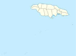
Anzahl der Inseln 4
Hauptinsel North-East Cay
Gesamtfläche 16 ha
Einwohner (unbewohnt)

Die Morant Cays sind eine Gruppe kleiner Inseln im Karibischen Meer. Sie liegen etwa 51 km südöstlich von Morant Point entfernt und stellen die östliche Landmasse Jamaikas dar.

Inhaltsverzeichnis

Verwaltung

Die Morant Cays werden verwaltungsmäßig zum Kingston Parish gerechnet.[1]

Geographie

Die aus vier Cays bestehende Gruppe hat als Fundament eine etwa 100 km² große und 7 km lange Korallenbank. Auf den Cays brüten Seevögel und Schildkröten. Im Auftrag des jamaikanischen Fischereiministeriums wurden auf der nordöstlichen Cay ein Leuchtturm und Unterkünfte für Fischer errichtet, die hier gelegentlich Guano sammeln und Fischen gehen.

Die Inseln von Norden nach Süden sind Northeast Cay (6,8 Hektar), Northwest Cay (1,2 Hektar), Southeast Cay (6,2 Hektar) und Southwest Cay (1,8 Hektar).[2]

Einzelnachweise

  1. [1] Morant and Pedro Cays Act, 1907
  2. [2] Flächenangaben anhand der maßstäblichen Detailkarte geschätzt

Weblinks


Wikimedia Foundation.

Игры ⚽ Нужно сделать НИР?

Schlagen Sie auch in anderen Wörterbüchern nach:

  • Morant Cays — NASA Landsat image of Morant Cays and Bank, visible color 33 percent brightness and +66 percent contrast enhanced Morant Cays is an offshore island group 51 km SSE off Morant Point, Jamaica. They are one of two offshore island groups belonging to …   Wikipedia

  • Morant Cays Lighthouse — Location Breezy Point, North East Cay, Morant Cays, Jamaica Coordinates 17°24′59″N 75°58′46″W /  …   Wikipedia

  • Morant — may refer to: Breaker Morant Breaker Morant Breaker Morant, 1980 film Breaker Morant, 1978 play Court martial of Breaker Morant People Angela Morant Blake Morant Clarice Morant Edward Morant George Soulié de Morant Henry Charles Frank Morant… …   Wikipedia

  • Morant Point Lighthouse — Morant Point Lighthouse …   Wikipedia

  • Cayos de Morant — Imagen satelital de los Cayos y el Banco de Morant. Los Cayos de Morant (en inglés: Morant Cays) son un grupo de islas a 51 kilómetros al sureste de Punta Morant en la isla principal de Jamaica. Se trata de uno de los dos grandes grupos de islas… …   Wikipedia Español

  • Pedro Cays — Lagekarte Gewässer Karibisches Meer Geographische Lage …   Deutsch Wikipedia

  • Geography of Jamaica — Sorosh Native name: Xaymaica Nickname: Land of Wood and Water Map of Jamaica …   Wikipedia

  • Jamaika — Jamaica Jamaika …   Deutsch Wikipedia

  • List of islands in the Caribbean — This is a list of islands of the Caribbean region, organized by the political territory each island belongs to.Anguilla* Anguilla * Anguillita * Blowing Rock * Cove Cay * Crocus Cay * Deadman s Cay * Dog Island * East Cay * Little Island * Little …   Wikipedia

  • Jamaica — Para otros usos de este término, véase Jamaica (desambiguación). Jamaica Jamaica …   Wikipedia Español

Share the article and excerpts

Direct link
Do a right-click on the link above
and select “Copy Link”