Mistastin Lake

Mistastin Lake
Mistastin Lake
Landsat-Bild
Landsat-Bild
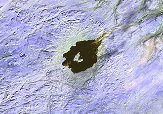
Geographische Lage Labrador in Neufundland und Labrador (Kanada)
Inseln Horseshoe Island
Daten
Koordinaten 55° 53′ N, 63° 18′ W55.883333333333-63.3338Koordinaten: 55° 53′ N, 63° 18′ W
Mistastin Lake (Neufundland und Labrador)
Mistastin Lake
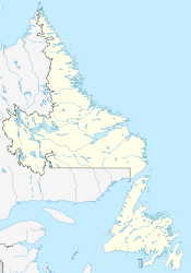
Höhe über Meeresspiegel 338 m
Fläche 145 km²f5
Länge 19 kmf6
Breite 12 kmf7
Besonderheiten

Impaktkrater

Mistastin Lake ist ein See in der Teilprovinz Labrador von Neufundland und Labrador in Kanada. Der annähernd kreisförmige See hat einen Durchmesser von 16 km.

Der See liegt in einem Impaktkrater, der vor 36,4 ± 4 Millionen Jahren im Eozän entstand und einen ursprünglichen Durchmesser von 28 km besaß.[1]

Die geologische Struktur weist einen Kraterrand aus Anhöhen bis zu 670 m über Meereshöhe auf. Der Durchmesser beträgt 26 km. Im Zentrum befindet sich der See Mistastin Lake, in dessen Mitte die bogenförmige Insel Horseshoe Island liegt, die das Relikt eines Zentralbergs darstellt.

Weblinks

Einzelnachweise

  1. Earth Impact Database - Mistastin
Mistastin Lake

Wikimedia Foundation.

Игры ⚽ Нужно решить контрольную?

Schlagen Sie auch in anderen Wörterbüchern nach:

  • Mistastin crater — Mistastin Lake Landsat Image Location Labrador, Newfoundland and Labrador, Canada Coordinates …   Wikipedia

  • Mien (lake) — Lake Mien Location Småland Coordinates …   Wikipedia

  • Siljan (lake) — Siljan Landsat 7 satellite image Coordinates …   Wikipedia

  • List of lakes in Canada — Canada has an extremely large number of lakes. The number of lakes larger than three square kilometres is estimated at close to 31,191 by the Atlas of Canada. There is no official estimate of the number of smaller lakes. This list is at best… …   Wikipedia

  • Список озёр Канады — Эта статья содержит незавершённый перевод с английского языка. Вы можете помочь проекту, переведя её до конца. Это список озёр Канады. В Канаде очень большое число озёр …   Википедия

  • Chicxulub crater — Imaging from NASA s Shuttle Radar Topography Mission STS 99 reveals part of the 180 kilometer (112 mi) diameter ring of the crater; clustered around the crater s trough are numerous sinkholes, suggesting a prehistoric oceanic basin in… …   Wikipedia

  • Liste der Einschlagkrater der Erde —  Karte mit allen Koordinaten: OSM, Google oder …   Deutsch Wikipedia

  • Cráter de Chicxulub — Saltar a navegación, búsqueda 21°24′N 89°31′O / 21.4, 89.517 …   Wikipedia Español

  • Middlesboro crater — This article is about the meteorite impact crater in Kentucky. For the meteorite that impacted in Middlesbrough, England in 1881, see Middlesbrough meteorite. The Middlesboro crater is a meteorite crater in Kentucky, United States.[1] It is named …   Wikipedia

  • Deep Bay crater — Deep Bay is a bay near the south western tip of Reindeer Lake in Saskatchewan, Canada. The bay is strikingly circular and very deep (220 m) in an otherwise irregular and shallow lake. The bay was formed in a 13 km wide impact crater. The age …   Wikipedia

Share the article and excerpts

Direct link
Do a right-click on the link above
and select “Copy Link”