- Lockyer Valley
-
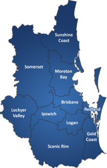 Lagekarte mit Lockyer Valley
 Grandchester-Eisenbahnstation
Das Lockyer Valley (deutsch: Lockyer-Tal) ist ein fruchtbares landwirtschaftliches Gebiet westlich von Brisbane in Queensland, Australien und östlich von Toowoomba. In diesem Tal werden vor allem Obst und Gemüse angebaut.
Das Tal ist nach dem britischen Major und Entdecker Edmund Lockyer benannt.
Inhaltsverzeichnis
Geographie
Das Tal schließt an die Great Dividing Range an; der größte Ort im Tal ist Gatton. Durch das Lockyer Valley fließt der Lockyer Creek, ein Nebenfluss des Brisbane River, der in die Moreton Bay mündet. Das Tal besitzt Staudämme, wie den Atkinson Dam (gebaut 1970), den Bill Gunn Dam und Lake Clarendon.
In dem Gebiet um das Tal gab es ab den 1870er Jahren deutsche Ansiedlungen wie Minden, Marburg, Haigslea (früher Kirchheim) sowie Prenzlau, das im Lockyer-Tal liegt. Weitere Orte im Tal sind Rosewood, Laidley, Forest Hill, Grandchester, Grantham (wurde in der Flut von 2011 nahezu in Gänze zerstört), Helidon und Withcott.
Geschichte
Gatton wurde 1855 gegründet und war einer der frühesten Orte der europäischen Besiedelung in Queensland.[1] Das Tal wurde durch deutsche Immigranten besiedelt, die durch den lutherischen Pastor Heussler betreut wurden.[2]
Die erste Eisenbahnlinie im Tal wurde von 1865 von Ipswich nach Grandchester gebaut, weil eine Holzindustrie in diesem Gebiet entstand.[2] Am 17. November 1960 wurde das Tal von einem Erdbeben der Stärke von 4,4 erschüttert, was zu erheblichen Zerstörungen führte.[3]
Im Lockyer Valley herrschen höhere Temperaturen als im Raum von Brisbane und im Winter ist es dort kälter. In November 2008 ereignete sich in diesem Tal eine Überflutung des landwirtschaftlichen Gebiets, die die Ernte völlig vernichtete und im Januar 2011 wurde das Tal erneut überflutet, wobei die Ernte und Baulichkeiten zerstört sowie zahlreiche Menschen zu Tode kamen.[4]
Landwirtschaft
Das Tal enthält fruchtbare schwarze Böden, die zu einer erfolgreichen Nutzung durch den Früchte- und Gemüseanbau mit einem umsatzstarken Handel führen. Allerdings wird der Erfolg des landwirtschaftlichen Anbaus durch Regen und Überflutungen gefährdet. Nach den jüngsten Fluten von Ende 2010 bis Mitte Januar 2011 und deren katastrophalen Folgen, wurde Obst und Gemüse in Australien knapp und die Preise dafür stiegen an.
Weblinks
Einzelnachweise
- ↑ Terry Ryder (14. Januar 2011): Lockyer food bowl banks on diversification. The Australian. News Limited. Abgerufen am 15. Januar 2011.
- ↑ a b Environmental Protection Agency (Queensland): Heritage Trails of the Great South East. State of Queensland 2000, ISBN 0-7345-1008-X
- ↑ Daniel Hurst (24. April 2008): Qld earthquake risk real. Brisbane Times. Fairfax Digital. Abgerufen am 14. Januar 2011.
- ↑ Lockyer Valley flash floods death toll now at 13, after five more bodies found, dozens still missing. The Courier Mail. Queensland Newspapers (14. Januar 2011). Abgerufen am 11. Januar 2011.
Kategorie:- Geographie (Queensland)


Wikimedia Foundation.