Lengyeltóti

Lengyeltóti
Lengyeltóti
Wappen von Lengyeltóti
Lengyeltóti (Ungarn)
Paris plan pointer b jms.svg
Basisdaten
Staat: Ungarn
Region: Dél-Dunántúl
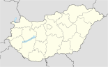
(Süd-Transdanubien)
Komitat: Somogy
Kleingebiet: Lengyeltóti
Koordinaten: 46° 40′ N, 17° 38′ O46.66717.6407Koordinaten: 46° 40′ 1″ N, 17° 38′ 27″ O
Fläche: 39,5 km²
Einwohner: 3.334 (1. Jän. 2010)
Bevölkerungsdichte: 84 Einwohner je km²

Lengyeltóti ist eine Stadt im Kleingebiet Lengyeltóti innerhalb des Komitats Somogy in Ungarn.

Lengyeltóti ist der Verwaltungssitz des Kleingebietes.

Lengyeltóti liegt 11 km südlich vom Balaton (deutsch Plattensee), dem größten See West- und Mitteleuropas.

Die Autobahn M7 verläuft nördlich in 6 km Entfernung.

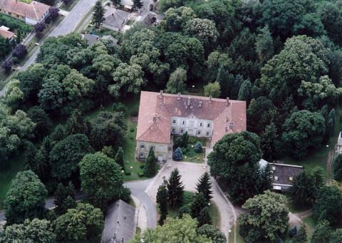
Schloss Zichy in Lengyeltóti

Inhaltsverzeichnis

Sehenswürdigkeiten

  • Schloss Zichy

Gemeindepartnerschaft

Es besteht seit 1994 eine Partnerschaft zur Gemeinde Dielheim in Baden-Württemberg.

Söhne und Töchter

Weblinks

 Commons: Lengyeltóti – Sammlung von Bildern, Videos und Audiodateien

Wikimedia Foundation.

Игры ⚽ Поможем сделать НИР

Schlagen Sie auch in anderen Wörterbüchern nach:

  • Lengyeltóti — Administration …   Wikipédia en Français

  • Lengyeltóti — Infobox Settlement subdivision type = Country subdivision name = HUN timezone=CET utc offset=+1 timezone DST=CEST utc offset DST=+2|official name=Lengyeltóti subdivision type1=County subdivision name1=Somogy area total km2=39.57 population… …   Wikipedia

  • Lengyeltoti — Original name in latin Lengyeltti Name in other language Lengyeltoti, Lengyeltti State code HU Continent/City Europe/Budapest longitude 46.67013 latitude 17.64398 altitude 147 Population 3380 Date 2012 01 18 …   Cities with a population over 1000 database

  • Lengyeltoti — Sp Leñdeltotis Ap Lengyeltoti L Vengrija …   Pasaulio vietovardžiai. Internetinė duomenų bazė

  • Kleingebiet Lengyeltóti — Das Kleingebiet Lengyeltóti (ungarisch Lengyeltóti kistérség) ist eine ungarische Verwaltungseinheit (LAU 1) innerhalb des Komitats Somogy in Ungarn. Der Verwaltungssitz ist Lengyeltóti. Im Kleingebiet Lengyeltóti lebten im Jahr 2007 auf einer… …   Deutsch Wikipedia

  • List of populated places in Hungary — This is a list of cities, towns and villages of Hungary Contents 1 A, Á 2 B 3 C …   Wikipedia

  • Somogyvár — Infobox Settlement subdivision type = Country subdivision name = HUN timezone=CET utc offset=+1 timezone DST=CEST utc offset DST=+2|official name=Somogyvár subdivision type1=County subdivision name1=Somogy area total km2=52.99 population… …   Wikipedia

  • Rita Kuti-Kis — Infobox Tennis player playername= Rita Kuti Kis country= HUN residence= Balatonlelle, Hungary datebirth= birth date and age|1978|2|13 placebirth= Lengyeltóti, Hungary height= height|m=1.76 weight= convert|66|kg|lb|abbr=on|lk=on turnedpro= 1991… …   Wikipedia

  • HU-SO — Koordinaten fehlen! Hilf mit. Somogy Somogy Komitatssitz: Kaposvár …   Deutsch Wikipedia

  • Komitat Somogy — Somogy …   Deutsch Wikipedia

Share the article and excerpts

Direct link
Do a right-click on the link above
and select “Copy Link”