- Kvichak River
-
Kvichak River 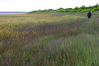
Sumpfgebiet am Oberlauf des Kvichak River
Daten Gewässerkennzahl US: 1405113 Lage Alaska (USA) Flusssystem Kvichak River Abfluss über Kvichak River → Beringmeer Quelle Iliamna Lake
59° 19′ 51″ N, 155° 52′ 56″ W59.330833-155.88222214Quellhöhe 14 m Mündung Kvichak Bay bei Kogging 58.880556-157.0372220Koordinaten: 58° 52′ 50″ N, 157° 2′ 14″ W
58° 52′ 50″ N, 157° 2′ 14″ W58.880556-157.0372220Mündungshöhe 0 m Höhenunterschied 14 m Länge 97 km Linke Nebenflüsse Alagnak River Der Kvichak River ist ein 97 km langer Fluss im Südwesten von Alaska am Übergang vom Festland zur Alaska-Halbinsel.
Er entspringt aus dem Iliamna Lake, fließt südwestwärts und mündet bei Kogging, 14 km nördlich von Naknek, in die Kvichak Bay, eine Bucht im Nordosten der Bristol Bay.
Die Bezeichnung der Ureinwohner Alaskas für den Fluss wurde 1828 von Kapitän Lutke von der kaiserlich russischen Marine als „Riviere Bristol“ oder „Riviere Kvitchak“ dokumentiert. Die Schreibweise „Kvichak“ stammt aus einer Karte des United States Bureau of Fisheries aus dem Jahr 1888.
Weblinks
Kategorien:- Flusssystem Kvichak River
- Fluss in Alaska
- Fluss in Nordamerika
- Lake and Peninsula Borough

Wikimedia Foundation.