- Kranji Expressway
-
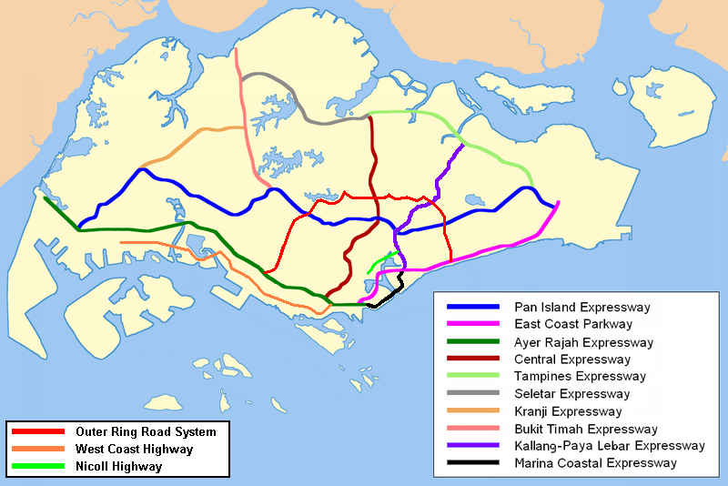
Kranji Expressway in Singapur 
Karte 
Basisdaten Betreiber: Land Transport Authority Gesamtlänge: 8 km - Jurong
- Choa Chu Kang
- Bukit Panjang
Straßenverlauf
(1) Gali Batu IC 


(2) Yew Tee IC (3) Choa Chu Kang East IC (4) Choa Chu Kang West IC (5) Lam San IC (7) Tengah IC 
Der Kranji Expressway (Abkürzung: KJE, chin.: 克兰 芝 高速公路; Pinyin: Kèlánzhī Gāosù Gōnglù; Tamil: கிராஞ்சி விரைவுச்சாலை; malay: Lebuhraya Kranji) ist eine Autobahn in Singapur. Sie verbindet den Bukit Timah Expressway (BKE) bei Bukit Panjang und verläuft danach Richtung Südwesten zum Pan Island Expressway (PIE) bei Jurong West. Der Bau der Schnellstraße begann 1990 und wurde 1994 abgeschlossen. Die Schnellstraße ist auch die kürzeste Schnellstraßen in Singapur mit etwa 8 Kilometern.
Stadtteile entlang der Autobahn
- Bukit Panjang
- Choa Chu Kang
- Jurong
Schlagen Sie auch in anderen Wörterbüchern nach:
Kranji Expressway — Infobox Singapore Expressway routebox length km = km to mi|num=8|abbr=no|spell=Commonwealth|precision=2|wiki=yes direction = Southwest East start/end1 = Jurong (PIE) start/end2 = Bukit Panjang (BKE) area = Jurong Choa Chu Kang Bukit Panjang… … Wikipedia
Pan Island Expressway — Infobox Singapore Expressway routebox length km = km to mi|num=42.8|abbr=no|spell=Commonwealth|precision=2|wiki=yes direction = West East start/end1 = Tuas (AYE) start/end2 = Changi South (ECP) area = Jurong Bukit Timah Toa Payoh Eunos Bedok… … Wikipedia
Marina Coastal Expressway — Route information Length: 5 km (3 mi) Existed: 2008 – present … Wikipedia
North–South Expressway, Singapore — For North–South Expressway in Malaysia, see North–South Expressway, Malaysia. North–South Expressway Route information Length: 21.5 km (13.4 mi) … Wikipedia
Seletar Expressway — Infobox Singapore Expressway routebox length km = km to mi|num=10.8|abbr=no|spell=Commonwealth|precision=2|wiki=yes direction = West East start/end1 = Kranji (BKE) start/end2 = Yio Chu Kang (CTE, TPE) area = Woodlands Yio Chu Kang construct start … Wikipedia
Seletar Expressway — Vorlage:Infobox hochrangige Straße/Wartung/SG E Seletar Expressway in Singapur Karte … Deutsch Wikipedia
List of Singapore-related topics — This is a list of topics related to Singapore. For a similar list in alphabetical order, see list of Singapore related topics by alphabetical order. Those interested in the subject can monitor changes to the pages by clicking on Related changes… … Wikipedia
List of Singapore-related topics by alphabetical order — This is a list of Singapore related topics by alphabetical order. For a list by topic, see list of Singapore related topics. Those interested in the subject can monitor changes to the pages by clicking on Related changes in the sidebar. A list of … Wikipedia
North South MRT Line — North South MRT Line 南北地铁线 வடக்கு தெற்கு எம்ஆர்டி வழி The North South Line is coloured red on system maps … Wikipedia
Choa Chu Kang — For other uses of CCK , see CCK (disambiguation). Not to be confused with Phua Chu Kang. Choa Chu Kang English Choa Chu Kang Chinese 蔡厝港 (Pinyin Càicuògǎng) (Hokkien POJ … Wikipedia
Kranji Expressway


18+
© Academic, 2000-2024
- Kontaktieren Sie uns: Unterstützung, Werbung
Wörterbücher Export, schritte mit PHP, Joomla, Drupal, WordPress, MODx.