- Kalamunda Shire
-
Shire of Kalamunda 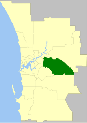
Lage des Kalamunda Shire in PerthGliederung Staat:  Australien
Bundesstaat:  Western Australia
Verwaltungssitz: Kalamunda Daten und Zahlen Fläche: 324,2 km² Einwohner: 49.534 (2006) [1] Bevölkerungsdichte: 153 Einwohner je km² Wards: 4 -31.966666666667116.05Koordinaten: 31° 58′ S, 116° 3′ ODas Shire of Kalamunda ist ein lokales Verwaltungsgebiet (LGA) im australischen Bundesstaat Western Australia. Kalamunda gehört zur Metropole Perth, der Hauptstadt von Western Australia. Das Gebiet ist 324 km² groß und hat etwa 49.500 Einwohner.
Kalamunda liegt am westlichen Rand des Stadtgebiets von Perth etwa 13 bis 30 km östlich des Stadtzentrums. Der Sitz des Shire Councils befindet sich im Stadtteil Kalamunda, wo etwa 6800 Einwohner leben[2].
Verwaltung
Der Kalamunda Council hat zwölf Mitglieder. Sie werden von den Bewohnern der vier Wards (je drei aus South East, South West, North und North West Ward) gewählt. Aus dem Kreis der Councillor rekrutiert sich auch der Ratsvorsitzende und Shire President.
Quellen
- ↑ Australian Bureau of Statistics (25. Oktober 2007): Kalamunda (S) (Local Government Area) (Englisch). 2006 Census QuickStats. Abgerufen am 24. Juli 2010.
- ↑ Australian Bureau of Statistics (25. Oktober 2007): Kalamunda (State Suburb) (Englisch). 2006 Census QuickStats. Abgerufen am 24. Juli 2010.
Weblinks
Kategorie:- Local Government Area in Western Australia

Wikimedia Foundation.