- Central Darling Shire
-
Central Darling Shire 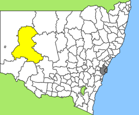
Lage des Central Darling Shire in New South WalesGliederung Staat:  Australien
Bundesstaat:  New South Wales
Verwaltungssitz: Wilcannia Daten und Zahlen Fläche: 53.511 km² Einwohner: 1.937 (2006) [1] Bevölkerungsdichte: 0,04 Einwohner je km² Wards: 3 -31.566666666667143.36666666667Koordinaten: 31° 34′ S, 143° 22′ OCentral Darling Shire ist ein lokales Verwaltungsgebiet (LGA) im australischen Bundesstaat New South Wales. Das Gebiet ist 53.511 km² groß und hat etwa 1.900 Einwohner.
Central Darling liegt tief im Westen des Staates etwa 960 km entfernt von der Metropole Sydney. Das Gebiet umfasst 57 Ortsteile und Ortschaften, darunter Ivanhoe, Menindee, White Cliffs und Wilcannia. Der Sitz des Shire Councils befindet sich in der Stadt Wilcannia im Zentrum der LGA, wo knapp 600 Einwohner leben.
Das Shire ist die größte LGA in New South Wales, es gibt aber nur drei LGAs mit weniger Einwohnern.
Verwaltung
Der Central Darling Shire Council hat zwölf Mitglieder, die von den Bewohnern der drei Wards gewählt werden (je vier Councillor aus A, B und C Ward). Diese drei Bezirke sind unabhängig von den Ortschaften festgelegt. Aus dem Kreis der Councillor rekrutiert sich auch der Mayor (Bürgermeister) des Councils.
Seit 20. November 2006 gehören nur noch drei der vier Councillor des C Ward dem Rat an, so dass der Rat bis zur nächsten Wahl im Herbst 2008 nur elf Mitglieder hat.
Weblinks
Einzelnachweise
- ↑ Australian Bureau of Statistics (25. Oktober 2007): Central Darling (A) (Local Government Area) (Englisch). 2006 Census QuickStats. Abgerufen am 6. April 2010.
Kategorie:- Local Government Area in New South Wales

Wikimedia Foundation.