- Cass County (Missouri)
-
Verwaltung US-Bundesstaat: Missouri Verwaltungssitz: Harrisonville Adresse des
Verwaltungssitzes:County Courthouse
102 East Wall Street
Harrisonville, MO 64701-2478Gründung: 3. März 1835 Gebildet aus: Jackson County Vorwahl: 001 816 Demographie Einwohner: 99.478 (2010) Bevölkerungsdichte: 55 Einwohner/km² Geographie Fläche gesamt: 1.820 km² Wasserfläche: 10 km² Karte 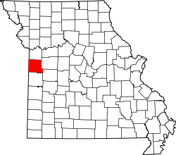
Website: www.casscounty.com Das Cass County[1] ist ein County im US-amerikanischen Bundesstaat Missouri. Bei der Volkszählung im Jahr 2010 hatte das County 99.478 Einwohner und eine Bevölkerungsdichte von 55 Einwohnern pro Quadratkilometer. Der Verwaltungssitz (County Seat) ist Harrisonville[2], das nach Albert G. Harrison benannt wurde, einem Mitglied im Kongress der Vereinigten Staaten.
Das Cass County ist Bestandteil der Metropolregion Kansas City.
Inhaltsverzeichnis
Geografie
Das County liegt im äußersten Westen, grenzt im Westen an Kansas und hat eine Fläche von 1.820 Quadratkilometern, wovon 10 Quadratkilometer Wasserfläche sind. Es grenzt an folgende Countys:
Johnson County
(Kansas)Jackson County Miami County
(Kansas)
Johnson County Bates County Henry County Geschichte
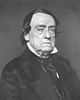 Lewis Cass
Das Cass County wurde am 3. März 1835 als Van Buren County aus Teilen des Jackson County gebildet. 1848 wurde es umbenannt in Cass County, benannt nach Lewis Cass, einem US - Senator und Präsidentschaftskandidaten.
Demografische Daten
Historische Einwohnerzahlen Census Einwohner ± in % 1850 6090 — 1860 9794 60 % 1870 19.296 100 % 1880 22.431 20 % 1890 23.301 4 % 1900 23.636 1 % 1910 22.973 -3 % 1920 21.536 -6 % 1930 20.962 -3 % 1940 19.534 -7 % 1950 19.325 -1 % 1960 29.702 50 % 1970 39.448 30 % 1980 51.029 30 % 1990 63.808 30 % 2000 82.092 30 % 2010 99.478 20 % Vor 1900[3] 1900–1990[4] 2000[5] 2010[6] Nach der Volkszählung im Jahr 2010 lebten im Cass County 99.478 Menschen in 35.957 Haushalten. Die Bevölkerungsdichte betrug 55 Einwohner pro Quadratkilometer.
Ethnisch betrachtet setzte sich die Bevölkerung zusammen aus 91,7 Prozent Weißen, 3,5 Prozent Afroamerikanern, 0,5 Prozent amerikanischen Ureinwohnern, 0,6 Prozent Asiaten sowie aus anderen ethnischen Gruppen; 2,0 Prozent stammten von zwei oder mehr Ethnien ab. Unabhängig von der ethnischen Zugehörigkeit waren 4,0 Prozent der Bevölkerung spanischer oder lateinamerikanischer Abstammung.
In den 35.957 Haushalten lebten statistisch je 2,68 Personen.
26,5 Prozent der Bevölkerung waren unter 18 Jahre alt, 61,6 Prozent waren zwischen 18 und 64 und 11,9 Prozent waren 65 Jahre oder älter. 50,7 Prozent der Bevölkerung war weiblich.
Das jährliche Durchschnittseinkommen eines Haushalts lag bei 59.226 USD. Das Pro - Kopf - Einkommen betrug 25.740 USD. 9,0 Prozent der Einwohner lebten unterhalb der Armutsgrenze.[7]
Städte und Gemeinden
- Archie
- Belton
- Cleveland
- Creighton
- Drexel1
- East Lynne
- Freeman
- Garden City
- Harrisonville
- Kansas City2
- Lake Annette
- Lake Winnebago
- Lee's Summit3
- Peculiar
- Pleasant Hill
- Raymore
- Strasburg
- Baldwin Park
- Gunn City
- Loch Lloyd
- West Line
1 - teilweise im Bates County
2 - teilweise im Clay, Jackson und im Platte County
3 - teilweise im Jackson CountyEinzelnachweise
- ↑ GNIS-ID: 758473. Abgerufen am 22. Februar 2011 (englisch).
- ↑ National Association of Counties Abgerufen am 16. Oktober 2011
- ↑ U.S. Census Bureau - Census of Population and Housing Abgerufen am 15. März 2011
- ↑ Auszug aus Census.gov Abgerufen am 18. Februar 2011
- ↑ Auszug aus factfinder.census.gov Abgerufen am 18. Februar 2011
- ↑ United States Census 2010 Abgerufen am 16. Oktober 2011
- ↑ U.S. Census Buero, State & County QuickFacts - Cass County Abgerufen am 16. Oktober 2011
Weblinks
-
 Commons: Cass County, Missouri – Sammlung von Bildern, Videos und Audiodateien
 - Offizielle Webseite
- U.S. Census Buero, State & County QuickFacts - Cass County
- Yahoo Bildersuche - Cass County
- www.city-data.com - Cass County

Liste der Countys in Missouri
Adair | Andrew | Atchison | Audrain | Barry | Barton | Bates | Benton | Bollinger | Boone | Buchanan | Butler | Caldwell | Callaway | Camden | Cape Girardeau | Carroll | Carter | Cass | Cedar | Chariton | Christian | Clark | Clay | Clinton | Cole | Cooper | Crawford | Dade | Dallas | Daviess | DeKalb | Dent | Douglas | Dunklin | Franklin | Gasconade | Gentry | Greene | Grundy | Harrison | Henry | Hickory | Holt | Howard | Howell | Iron | Jackson | Jasper | Jefferson | Johnson | Knox | Laclede | Lafayette | Lawrence | Lewis | Lincoln | Linn | Livingston | Macon | Madison | Maries | Marion | McDonald | Mercer | Miller | Mississippi | Moniteau | Monroe | Montgomery | Morgan | New Madrid | Newton | Nodaway | Oregon | Osage | Ozark | Pemiscot | Perry | Pettis | Phelps | Pike | Platte | Polk | Pulaski | Putnam | Ralls | Randolph | Ray | Reynolds | Ripley | Saline | Schuyler | Scotland | Scott | Shannon | Shelby | St. Charles | St. Clair | St. Francois | St. Louis County | St. Louis City | Ste. Genevieve | Stoddard | Stone | Sullivan | Taney | Texas | Vernon | Warren | Washington | Wayne | Webster | Worth | Wright
Wikimedia Foundation.
Schlagen Sie auch in anderen Wörterbüchern nach:
Cass County, Missouri — Infobox U.S. County county = Cass County state = Missouri founded year = 1835 seat wl = Harrisonville area total sq mi =703 area land sq mi =699 area water sq mi =4 area percentage = 0.52% census yr = 2007 pop = 97133 density km2 =53.3 web =… … Wikipedia
Cass County — is the name of nine counties in the United States: Cass County, Illinois Cass County, Indiana Cass County, Iowa Cass County, Michigan Cass County, Minnesota Cass County, Missouri Cass County, Nebraska Cass County, North Dakota Cass County, Texas… … Wikipedia
Cass County — Es gibt in den Vereinigten Staaten neun Countys mit dem Namen Cass County: Cass County (Illinois) Cass County (Indiana) Cass County (Iowa) Cass County (Michigan) Cass County (Minnesota) Cass County (Missouri) Cass County (Nebraska) Cass County… … Deutsch Wikipedia
Cass County Courthouse — ist die Bezeichnung mehrerer Courthouses in den Vereinigten Staaten: Cass County Courthouse (Illinois) Cass County Courthouse (Indiana) Cass County Courthouse (Iowa), NRHP Nr. 03000819 Cass County Courthouse (Michigan) Cass County Courthouse… … Deutsch Wikipedia
Cass County (Iowa) — Das Cass County Courthouse in Atlantic, seit 2003 im NRHP gelistet[1] Verwaltung … Deutsch Wikipedia
Cass County (Nebraska) — Das Cass County Courthouse in Plattsmouth, gelistet im NRHP Nr. 89002248[1] Verwaltung … Deutsch Wikipedia
Cass County — Comté de Cass Pour les articles homonymes, voir Cass. Cette page d’homonymie répertorie les différents comtés partageant un même nom. Neuf comtés des États Unis portent le nom de comté de Cass (Cass County) : Comté de Cass … Wikipédia en Français
Jackson County, Missouri — Location in the state of Missouri … Wikipedia
Jackson County (Missouri) — Das Jackson County Courthouse im Kansas City Verwaltung US Bundesstaat: Missouri … Deutsch Wikipedia
Douglas County, Missouri — Location in the state of Missouri … Wikipedia
Cass County (Missouri)


18+
© Academic, 2000-2024
- Kontaktieren Sie uns: Unterstützung, Werbung
Wörterbücher Export, schritte mit PHP, Joomla, Drupal, WordPress, MODx.