Donnybrook-Balingup Shire

Donnybrook-Balingup Shire
Shire of Donnybrook-Balingup
Donnybrook-balingup LGA WA.png
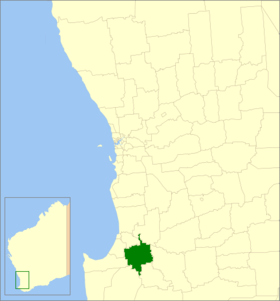
Lage des Donnybrook-Balingup Shire in Westaustralien
Gliederung
Staat: Australien Australien
Bundesstaat: Flag of Western Australia.svg Western Australia
Verwaltungssitz: Donnybrook
Daten und Zahlen
Fläche: 1.560,3 km²
Einwohner: 4.741 (2006) [1]
Bevölkerungsdichte: 3 Einwohner je km²
-33.566666666667115.81666666667

Das Shire of Donnybrook-Balingup ist ein lokales Verwaltungsgebiet (LGA) im australischen Bundesstaat Western Australia. Das Gebiet ist 1560 km² groß und hat etwa 4700 Einwohner.

Donnybrook-Balingup liegt im Westen des Staates etwa 180 km südlich der Hauptstadt Perth. Der Sitz des Shire Councils befindet sich in der Ortschaft Donnybrook, wo etwa 460 Einwohner leben[2].

Verwaltung

Der Donnybrook-Balingup Council hat neun Mitglieder. Sie werden von allen Bewohnern des Shires gewählt. Donnybrook-Balingup ist nicht in Bezirke unterteilt. Aus dem Kreis der Councillor rekrutiert sich auch der Vorsitzende des Councils (Shire President).

Quellen

  1. Australian Bureau of Statistics (25. Oktober 2007): Donnybrook-Balingup (S) (Local Government Area) (Englisch). 2006 Census QuickStats. Abgerufen am 24. Juli 2010.
  2. Australian Bureau of Statistics (25. Oktober 2007): Donnybrook (L) (Urban Centre/Locality) (Englisch). 2006 Census QuickStats. Abgerufen am 24. Juli 2010.

Weblinks


Wikimedia Foundation.

Игры ⚽ Нужно решить контрольную?

Schlagen Sie auch in anderen Wörterbüchern nach:

  • Shire of Donnybrook-Balingup — This article is about a local government area. For the town, see Donnybrook, Western Australia. Shire of Donnybrook Balingup Western Australia …   Wikipedia

  • Balingup, Western Australia — Infobox Australian Place | type = town name = Balingup state = wa caption = lga = Shire of Donnybrook Balingup postcode = 6253 est = 1898 pop = 443 (2006 Census) [Census 2006 AUS|id=SSC53086|name=Balingup (State Suburb)|quick=on|accessdate=2008… …   Wikipedia

  • Donnybrook, Western Australia — Donnybrook Western Australia Donnybrook Main Street …   Wikipedia

  • Shire of Murchison — Western Australia Location in Western Australia Population …   Wikipedia

  • Shire of Derby-West Kimberley — Western Australia Population: 7,9 …   Wikipedia

  • Shire of Christmas Island — Population: 1,440(2009)[1] …   Wikipedia

  • Shire of Ngaanyatjarraku — Western Australia Location in Western Australia Population …   Wikipedia

  • Shire of Boyup Brook — Infobox Australian Place | type = lga name = Shire of Boyup Brook state = wa imagesize= 180 caption = Location in Western Australia pop = 1,480 (2006 census) area = 2829.2 est = 1896 seat = Boyup Brook mayor = Roger Downing region = South West… …   Wikipedia

  • Shire of Capel — Infobox Australian Place | type = lga name = Shire of Capel state = wa imagesize= 180 caption = Location in Western Australia pop = 10,206 (2006 census) area = 557.6 est = 1894 seat = Capel mayor = Murray Scott region = South West url =… …   Wikipedia

  • Shire of Dardanup — Infobox Australian Place | type = lga name = Shire of Dardanup state = wa imagesize= 180 caption = Location in Western Australia pop = 10,339 (2006 census) area = 526.6 est = 1894 seat = Eaton mayor = B.G. (Brad) Day region = South West url =… …   Wikipedia

Share the article and excerpts

Direct link
Do a right-click on the link above
and select “Copy Link”