Derby (Western Australia)

Derby (Western Australia)
Derby
BoabPrisonTree.jpg
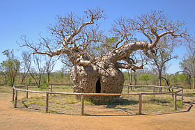
Der "Boab Prison Tree" nahe Derby wurde tatsächlich als Gefängnis genutzt.
Staat: Australien Australien
Bundesstaat: Flag of Western Australia.svg Western Australia
Gegründet: 1880er
Koordinaten: 17° 18′ S, 123° 38′ O-17.303055555556123.628888888898Koordinaten: 17° 18′ S, 123° 38′ O
Höhe: m
 
Einwohner: 3.093 (2006) [1]
 
Zeitzone: AWST (UTC+8)
LGA: Shire of Derby-West Kimberley
Derby (Australien)
Derby
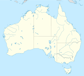
Derby

Derby ist eine Stadt in der Kimberley-Region in Western Australia. Sie ist eine von nur drei Städten der Region mit mehr als 2000 Einwohnern (momentan ca. 5000 Einwohner). Sie wurde um 1880 gegründet und liegt am Delta des Fitzroy River. Die Stadt ist auch der Geburtsort von Everlyn Sampi, einer australischen Schauspielerin.

1922 wurde in Derby von Western Australian Airways die erste regelmäßige Fluglinie Australiens eröffnet. Zielpunkt war Geraldton.

Während des Zweiten Weltkrieges wurde die Stadt von japanischen Fliegern attackiert. Die Stadt spielte auch eine wichtige Rolle im Royal Flying Doctor Service of Australia für die Region.

Weblinks

 Commons: Derby, Western Australia – Sammlung von Bildern, Videos und Audiodateien

Einzelnachweise

  1. Australian Bureau of Statistics (25. Oktober 2007): Derby (Urban Centre/Locality) (Englisch). 2006 Census QuickStats. Abgerufen am 13. Februar 2011.

Wikimedia Foundation.

Игры ⚽ Нужна курсовая?

Schlagen Sie auch in anderen Wörterbüchern nach:

  • Derby, Western Australia — Derby Western Australia This boab tree near Derby was actually used as a prison, hence the name the Boab Prison Tree …   Wikipedia

  • Western Australia — Western Australian. a state in W Australia. 1,273,624; 975,920 sq. mi. (2,527,635 sq. km). Cap.: Perth. * * * State (pop., 2001: 1,906,114), western Australia. Covering 976,790 sq mi (2,529,880 sq km), it constitutes one third of the continent s… …   Universalium

  • Kimberley (Western Australia) — The Kimberley is one of the nine regions of Western Australia. It is located in the northern part of Western Australia, bordered on the west by the Indian Ocean, on the north by the Timor Sea, on the south by the Great Sandy and Tanami Deserts,… …   Wikipedia

  • Bardi, Western Australia — Bardi Western Australia …   Wikipedia

  • Fremantle, Western Australia — Infobox Australian Place | type = suburb name = Fremantle city = Perth state = wa caption = Aerial view of Fremantle port lga = City of Fremantle postcode = 6160 est = 1829 pop = 7,643Census 2001 AUS|id=SSC51481|name=Fremantle (State… …   Wikipedia

  • Camballin, Western Australia — Infobox Australian Place | type = town name = Camballin state = wa caption = lga = Shire of Derby West Kimberley postcode = 6728 est = pop = stategov = Kimberley fedgov = Kalgoorlie dist1 = 8 | location1= Loomacoord|… …   Wikipedia

  • List of highways in Western Australia — Western Australia s population is mainly concentrated in the south west. Outside of Perth the population is relatively sparse when compared to rural areas of the eastern states. Most of the highways are found here.In many cases, roads away from… …   Wikipedia

  • Derby Highway — Length 42 km (26 mi) Direction North South From Loch Street, Derby, Western Australia To …   Wikipedia

  • List of pastoral leases in Western Australia — Pastoral leases are increasingly known as stations , and more particular as either sheep stations or cattle stations. They are usually found in country that is designated as rangeland. In Western Australia, all leases are up for renewal or… …   Wikipedia

  • List of major roads in rural Western Australia — This page details the freeways, highways, roads and tracks in rural and remote in Western Australia, not including the Perth metropolitan area.A list of the routes (most involving multiple roads) is available at List of road routes in rural and… …   Wikipedia

Share the article and excerpts

Direct link
Do a right-click on the link above
and select “Copy Link”