Cocos Island (Guam)

Cocos Island (Guam)

Vorlage:Infobox Insel/Wartung/Höhe fehlt

Cocos Island
Nautische Karte der Cocos Lagoon und Cocos Island
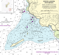
Gewässer Pazifischer Ozean
Inselgruppe Marianen
Geographische Lage 13° 14′ 10″ N, 144° 38′ 56″ O13.236111111111144.64888888889Koordinaten: 13° 14′ 10″ N, 144° 38′ 56″ O
Cocos Island (Nördliche Marianen)
Cocos Island
Länge 1,6 km
Breite 300 m
Fläche 0,96 km²
Einwohner (unbewohnt)
Guam mit dem vorgelagerten Cocos Island

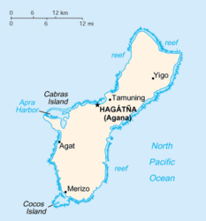
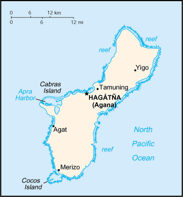
Cocos Island (Chamorro:Islan Dåno) ist eine unbewohnte Insel, die 1,6 km südlich vor Guam liegt. Das 300 m breite und etwa 1,6 km lange Eiland ist die südlichste Insel der Marianen und hat eine Fläche von knapp einem Quadratkilometer.

Die United States Coast Guard betrieb auf der Insel zwischen 1944 und 1963 die LORAN-Station Barrigada. Die Elektrik und Transformatoren der Station sind im Lauf der Jahre verwittert und haben zu einer starken PCB-Belastung in der, zwischen Guam und Cocos-Island gelegenen, Cocos-Lagune geführt. So werden die Grenzwerte für PCB im Wasser und den hier gefangenen Fischen noch heute deutlich überschritten.

Auf der Westseite von Cocos Island gibt es einen Hotelkomplex für Urlauber.


Wikimedia Foundation.

Игры ⚽ Нужен реферат?

Schlagen Sie auch in anderen Wörterbüchern nach:

  • Cocos Island (Guam) — For other uses, see Coconut Island (disambiguation). Not to be confused with Isla del Coco or Cocos Keeling Islands. NOAA nautical chart of Cocos Lagoon, with Cocos Island in the southwest (lower left) Cocos Island (Chamorro: Islan Dåno) is an… …   Wikipedia

  • Cocos Island (disambiguation) — Island(s) called Cocos, Coco or Coconut include the following: Cocos: Cocos Island, off the Pacific coast of Costa Rica Cocos (Keeling) Islands, a territory of Australia in the Indian Ocean Cocos Island (Guam), one mile off the southern tip of… …   Wikipedia

  • Cocos (Keeling) Islands — Cocos Islands redirects here. It is not to be confused with Cocos Island or Coco Islands. Territory of the Cocos (Keeling) Islands …   Wikipedia

  • Cocos — may refer to: Cocos (genus), a plant genus with the coconut as its only accepted species Cocos Lagoon, south of Guam Cocos Malays, an ethnic group inhabiting the Cocos (Keeling) Islands Cocos Plate, a tectonic plate beneath the Pacific Ocean… …   Wikipedia

  • Guam — This article is about the United States island territory of Guam. For GUAM, an eastern European international organization, see GUAM Organization for Democracy and Economic Development. Guam Guåhan …   Wikipedia

  • Cocos Lagoon — NOAA nautical chart of Cocos Lagoon Cocos Lagoon appears as a small incomplete coral atoll attached to the southwestern coast of Guam in the area of the village of Merizo. It stretches about 5.5 km east west and 3.5 km north south, covering an… …   Wikipedia

  • Cocos Islands — Îles Cocos  Pour l’île appartenant au Costa Rica, voir île Cocos. Îles Cocos Cocos Island (en) …   Wikipédia en Français

  • Merizo, Guam — Merizo Malesso   Village   Location of Merizo within the Territory of Guam. Country …   Wikipedia

  • List of Guam-related topics — The following is a list of topics about the United States Territory of Guam. NOTOC compactTOC4 0–9A*Agriculture in Guam * *Archaeology of Guam *Architecture of Guam *Area code 671 *B*Birds of Guam * **C*Capital of Guam *Chamorro people ** ***… …   Wikipedia

  • Geography of Guam — Guam Native name: Guåhån Map of Guam (See detailed map) …   Wikipedia

Share the article and excerpts

Direct link
Do a right-click on the link above
and select “Copy Link”