- Calhoun County (Iowa)
-
Verwaltung US-Bundesstaat: Iowa Verwaltungssitz: Rockwell City Adresse des
Verwaltungssitzes:County Courthouse
416 4th Street, Suite 1
Rockwell City, IA 50579-1428Gründung: 15. Januar 1851 Gebildet aus: Original-County Vorwahl: 001 712 Demographie Einwohner: 9670 (2010) Bevölkerungsdichte: 6,6 Einwohner/km² Geographie Fläche gesamt: 1.482 km² Wasserfläche: 6 km² Karte 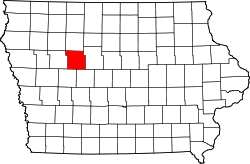
Website: www.calhouncountyiowa.com/ Das Calhoun County[1] ist ein County im US-amerikanischen Bundesstaat Iowa. Bei der Volkszählung im Jahr 2010 hatte das County 9.670 Einwohner und eine Bevölkerungsdichte von 9,6 Einwohnern pro Quadratkilometer. Der Verwaltungssitz (County Seat) ist Rockwell City.[2]
Inhaltsverzeichnis
Geografie
Das County liegt nordwestlich des geografischen Zentrums von Iowa und hat eine Fläche von 1.482 Quadratkilometern, wovon 6 Quadratkilometer Wasserfläche sind. Es grenzt an folgende Countys:
Pocahontas County Sac County 
Webster County Carroll County Greene County Geschichte
 Calhoun
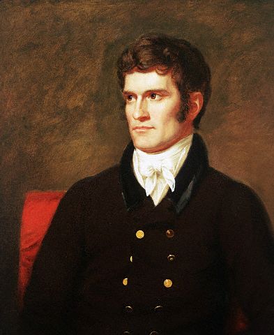
Das Calhoun County wurde am 15. Januar 1851 aus als frei bezeichneten - in Wirklichkeit aber von Indianern besiedelten - Territorium gebildet. Benannt wurde es 1853 nach John C. Calhoun (1782-1850), dem 7. Vizepräsidenten der Vereinigten Staaten.
Als 1870 die Schienen der Illinois Central Railroad auch durch dieses County gelegt wurden, verlegte man den Sitz der County-Verwaltung von Lake City nach Rockwell City. Der erste Zug erreichte Rockwell City am 7. August 1882 und die Einwohnerzahl verdoppelte sich noch im gleichen Jahr. Das erste, aus Holz erbaute Gerichtsgebäude brannte 1884 völlig nieder und die Verwaltung wurde in ein nahe gelegenes Hotel verlegt. 1913 wurde das noch heute verwendete Gerichtsgebäude erbaut.
Ab 1890 wurden im großen Stil Drainagen durch das County gebaut, um das Land trocken zu legen und mehr gutes Farmland zu erhalten. In den Jahren danach kristallisierte sich dies als die richtige Lösung heraus und das County wurde zu einem der landwirtschaftlich produktivsten und erfolgreichsten im ganzen Bundesstaat.
Demografische Daten
Historische Einwohnerzahlen Census Einwohner ± in % 1860 147 — 1870 1602 1.000 % 1880 5595 200 % 1890 13.107 100 % 1900 18.569 40 % 1910 17.090 -8 % 1920 17.783 4 % 1930 17.605 -1 % 1940 17.584 -0,1 % 1950 16.925 -4 % 1960 15.923 -6 % 1970 14.287 -10 % 1980 13.542 -5 % 1990 11.508 -20 % 2000 11.115 -3 % 2010 9670 -10 % Vor 1900[3] 1900–1990[4] 2000[5] 2010[6] Nach der Volkszählung im Jahr 2010 lebten im Calhoun County 9.670 Menschen in 4.293 Haushalten. Die Bevölkerungsdichte betrug 9,6 Einwohner pro Quadratkilometer.
Ethnisch betrachtet setzte sich die Bevölkerung zusammen aus 98,5 Prozent Weißen, 0,2 Prozent Afroamerikanern, 0,2 Prozent amerikanischen Ureinwohnern, 0,2 Prozent Asiaten sowie aus anderen ethnischen Gruppen; 0,6 Prozent stammten von zwei oder mehr Ethnien ab. Unabhängig von der ethnischen Zugehörigkeit waren 0,9 Prozent der Bevölkerung spanischer oder lateinamerikanischer Abstammung.
In den 4.293 Haushalten lebten statistisch je 2,15 Personen.
21,2 Prozent der Bevölkerung waren unter 18 Jahre alt, 55,1 Prozent waren zwischen 18 und 64 und 23,7 Prozent waren 65 Jahre oder älter. 51,4 Prozent der Bevölkerung war weiblich.
Das jährliche Durchschnittseinkommen eines Haushalts lag bei 44.833 USD. Das Pro - Kopf - Einkommen betrug 22.195 USD. 11,2 Prozent der Einwohner lebten unterhalb der Armutsgrenze.[7]
Städte und Gemeinden
- Farnhamville1
- Jolley
- Knierim
- Lake City
- Lohrville
- Lytton2
- Manson
- Pomeroy
- Rinard
- Rockwell City
- Somers
- Yetter
- Knoke
- Lanedale
- Lavinia
- Piper
- Rands
- Richards
- Sherwood
- Wieston
1 - teilweise im Webster County
2 - teilweise im Sac CountyEinzelnachweise
- ↑ GNIS-ID: 465202. Abgerufen am 23. Februar 2011 (englisch).
- ↑ National Association of Counties Abgerufen am 6. November 2011
- ↑ U.S. Census Bureau - Census of Population and Housing Abgerufen am 15. März 2011
- ↑ Auszug aus Census.gov Abgerufen am 16. Februar 2011
- ↑ U.S. Census Buero - Volkszählungsdaten 2000 für das Calhoun County, IA Abgerufen am 7. November 2011
- ↑ United States Census 2010 Abgerufen am 21. Februar 2011
- ↑ U.S. Census Buero, State & County QuickFacts - Calhoun County Abgerufen am 6. November 2011
Weblinks
-
 Commons: Calhoun County, Iowa – Sammlung von Bildern, Videos und Audiodateien
 - Offizielle Webseite
- U.S. Census Buero, State & County QuickFacts - Calhoun County
- Yahoo Bildersuche - Calhoun County
- www.city-data.com

Liste der Countys in Iowa
Adair | Adams | Allamakee | Appanoose | Audubon | Benton | Black Hawk | Boone | Bremer | Buchanan | Buena Vista | Butler | Calhoun | Carroll | Cass | Cedar | Cerro Gordo | Cherokee | Chickasaw | Clarke | Clay | Clayton | Clinton | Crawford | Dallas | Davis | Decatur | Delaware | Des Moines | Dickinson | Dubuque | Emmet | Fayette | Floyd | Franklin | Fremont | Greene | Grundy | Guthrie | Hamilton | Hancock | Hardin | Harrison | Henry | Howard | Humboldt | Ida | Iowa | Jackson | Jasper | Jefferson | Johnson | Jones | Keokuk | Kossuth | Lee | Linn | Louisa | Lucas | Lyon | Madison | Mahaska | Marion | Marshall | Mills | Mitchell | Monona | Monroe | Montgomery | Muscatine | O'Brien | Osceola | Page | Palo Alto | Plymouth | Pocahontas | Polk | Pottawattamie | Poweshiek | Ringgold | Sac | Scott | Shelby | Sioux | Story | Tama | Taylor | Union | Van Buren | Wapello | Warren | Washington | Wayne | Webster | Winnebago | Winneshiek | Woodbury | Worth | Wright
Wikimedia Foundation.
Schlagen Sie auch in anderen Wörterbüchern nach:
Calhoun Township, Calhoun County, Iowa — Infobox Settlement official name = Calhoun Township, Calhoun County settlement type = Township nickname = motto = imagesize = image caption = image imagesize = image caption = image mapsize = map caption = mapsize1 = map caption1 = subdivision… … Wikipedia
Calhoun County, Iowa — Infobox U.S. County county = Calhoun County state = Iowa seallink = map size = 250 founded = 1855 seat = Rockwell City largest city = 572 square miles (1,482 km²). 570 square miles (1,477 km²) of it is land and 2 square miles (6 km²) of it (0.37% … Wikipedia
National Register of Historic Places listings in Calhoun County, Iowa — Location of Calhoun County in Iowa This is a list of the National Register of Historic Places listings in Calhoun County, Iowa. This is intended to be a complete list of the properties and districts on the National Register of Historic Places in… … Wikipedia
Center Township, Calhoun County, Iowa — Infobox Settlement official name = Center Township, Calhoun County, Iowa settlement type = Township nickname = motto = imagesize = image caption = image imagesize = image caption = image mapsize = map caption = mapsize1 = map caption1 =… … Wikipedia
Butler Township, Calhoun County, Iowa — Infobox Settlement official name = Butler Township, Calhoun County settlement type = Township nickname = motto = imagesize = image caption = image imagesize = image caption = image mapsize = map caption = mapsize1 = map caption1 = subdivision… … Wikipedia
Cedar Township, Calhoun County, Iowa — Infobox Settlement official name = Cedar Township, Calhoun County settlement type = Township nickname = motto = imagesize = image caption = image imagesize = image caption = image mapsize = map caption = mapsize1 = map caption1 = subdivision type … Wikipedia
Elm Grove Township, Calhoun County, Iowa — Infobox Settlement official name = Elm Grove Township, Calhoun County settlement type = Township nickname = motto = imagesize = image caption = image imagesize = image caption = image mapsize = map caption = mapsize1 = map caption1 = subdivision… … Wikipedia
Garfield Township, Calhoun County, Iowa — Infobox Settlement official name = Garfield Township, Calhoun County settlement type = Township nickname = motto = imagesize = image caption = image imagesize = image caption = image mapsize = map caption = mapsize1 = map caption1 = subdivision… … Wikipedia
Greenfield Township, Calhoun County, Iowa — Infobox Settlement official name = Greenfield Township, Calhoun County settlement type = Township nickname = motto = imagesize = image caption = image imagesize = image caption = image mapsize = map caption = mapsize1 = map caption1 = subdivision … Wikipedia
Jackson Township, Calhoun County, Iowa — Infobox Settlement official name = Jackson Township, Calhoun County settlement type = Township nickname = motto = imagesize = image caption = image imagesize = image caption = image mapsize = map caption = mapsize1 = map caption1 = subdivision… … Wikipedia
Calhoun County (Iowa)


18+
© Academic, 2000-2024
- Kontaktieren Sie uns: Unterstützung, Werbung
Wörterbücher Export, schritte mit PHP, Joomla, Drupal, WordPress, MODx.