- Cagayancillo
-
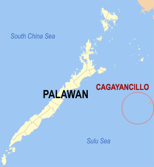
Municipality of Cagayancillo Lage von Cagayancillo in der Provinz Palawan 
Basisdaten Bezirk: Western Visayas Provinz: Palawan Barangays: 12 Distrikt: 1. Distrikt von Palawan PSGC: 175308000 Einkommensklasse: 5. Einkommensklasse Haushalte: 947 Zensus 1. Mai 2000Einwohnerzahl: 6.506 Zensus 1. August 2007Koordinaten: 9° 35′ N, 121° 12′ O9.5833333333333121.2Koordinaten: 9° 35′ N, 121° 12′ O Postleitzahl: 5321 Geographische Lage auf den Philippinen 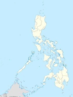

Cagayancillo Cagayancillo ist eine philippinische Stadtgemeinde in der Provinz Palawan. Nach dem Zensus vom 1. Mai 2000 hat sie 6348 Einwohner in 947 Haushalten.
Baranggays
Cagayancillo ist politisch in zwölf Baranggays unterteilt.
- Bantayan (Pob.)
- Calsada (Pob.)
- Convento (Pob.)
- Lipot North (Pob.)
- Lipot South (Pob.)
- Magsaysay
- Mampio
- Nusa
- Santa Cruz
- Tacas (Pob.)
- Talaga
- Wahig (Pob.)
Städte und Stadtgemeinden in der Provinz PalawanStädte: Puerto Princesa City
Stadtgemeinden: Aborlan | Agutaya | Araceli | Balabac | Bataraza | Brooke's Point | Busuanga | Cagayancillo | Coron | Culion | Cuyo | Dumaran | El Nido | Kalayaan | Linapacan | Magsaysay | Narra | Quezon | Rizal | Roxas | San Vicente | Sofronio Española | Taytay
Wikimedia Foundation.
Schlagen Sie auch in anderen Wörterbüchern nach:
Cagayancillo — Original name in latin Cagayancillo Name in other language Cagayancillo, Nalad Cagayancillo State code PH Continent/City Asia/Manila longitude 9.57694 latitude 121.20722 altitude 35 Population 0 Date 2011 07 31 … Cities with a population over 1000 database
Cagayancillo (Palawan) — Saltar a navegación, búsqueda Mapa de Palawan que muestra la posición de Cagayancillo. Cagayancillo es una municipalidad de la provincia de Palawan, en Filipinas. De acuerdo con el censo del 2000, tiene una población de 6,348 habitantes en 947… … Wikipedia Español
Cagayancillo, Palawan — Cagayancillo is a 6th class municipality in the province of Palawan, Philippines. According to the 2000 census, it has a population of 6,348 people in 947 households.BarangaysCagayancillo is politically subdivided into 12 barangays.* Bantayan… … Wikipedia
Palawan — Infobox Philippine province name = Palawan sealfile = Ph seal palawan.png region = MIMAROPA (Region IV B) (in transitioncite web url=http://www.ops.gov.ph/records/eo no429.htm title=Executive Order No. 429 date=May 23, 2005 author=President of… … Wikipedia
Balabac — Municipality of Balabac Lage von Balabac in der Provinz Palawan Basisdaten Bezirk: W … Deutsch Wikipedia
Brooke's Point — Municipality of Brooke s Point Lage von Brooke s Point in der Provinz Palawan Basisdaten Bezirk: Western Visayas … Deutsch Wikipedia
Cagayan Island — Karte von Palawan mit der Lage der Insel Cagayan Der Cagayan Archipel ist eine Inselgruppe inmitten der Sulusee, einem Nebenmeer des Pazifischen Ozeans. Die Inseln liegen 248 km von Puerto Princesa (Palawan, Philippinen) entfernt, etwa 6 8… … Deutsch Wikipedia
PH-PLW — Palawan in der philippinischen Inselwelt Palawan ist die Hauptinsel der gleichnamigen Provinz und die drittgrößte Inselgruppe der Philippinen. Die Hauptstadt Puerto Princesa liegt etwa in der Mitte der Südküste an der Sulusee, 500 km südwestlich… … Deutsch Wikipedia
Puerto Princessa — Puerto Princesa City Lage von Puerto Princesa in der Provinz Palawan Basisdaten Bezirk: Western Visayas … Deutsch Wikipedia
Palawan — Saltar a navegación, búsqueda Provincia de Palawan … Wikipedia Español
Cagayancillo

18+
© Academic, 2000-2024
- Kontaktieren Sie uns: Unterstützung, Werbung
Wörterbücher Export, schritte mit PHP, Joomla, Drupal, WordPress, MODx.