- Beartooth Mountains
-
Beartooth Mountains 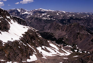
Berge in den Beartooth Mountains
Höchster Gipfel Granite Peak (3.904 m) Lage Montana / Wyoming (USA) Teil der Rocky Mountains 

Koordinaten 45° 10′ N, 109° 52′ W45.16-109.863904Koordinaten: 45° 10′ N, 109° 52′ W Die Beartooth Mountains befinden sich im südlichen Montana und im nordwestlichen Wyoming (USA) und sind Teil der 900.000 Acre (3800 km²) großen Absaroka-Beartooth-Wilderness. Granite Peak ist der höchste Berg und mit 3904 m gleichzeitig der höchste Punkt im Bundesstaat Montana. Die Berge liegen unweit nordöstlich des Yellowstone-Nationalparks und sind Teil des größeren Yellowstone-Ökosystems. Durch die Berge verläuft der Beartooth Highway (US 212) mit der höchsten Erhebung auf Beartooth Pass auf 3345 m. Der Name des Gebirges wird einer Erhebung im Relief der Bergkette zugeschrieben, welche wie ein Bärenzahn aussieht.
-

Der namensgebende Bear's Tooth (Bärenzahn) in den Beartooth Mountains
Weblinks
Kategorien:- Geographie (Montana)
- Geographie (Wyoming)
- Yellowstone-Nationalpark
-


Wikimedia Foundation.