- Baillie-Hamilton Island
-
Baillie-Hamilton Island Gewässer Arktischer Ozean Inselgruppe Königin-Elisabeth-Inseln Geographische Lage 75° 53′ N, 94° 35′ W75.883333333333-94.583333333333Koordinaten: 75° 53′ N, 94° 35′ W 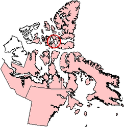
Länge 26 km Breite 12 km Fläche 290 km² Einwohner (unbewohnt) Die Baillie-Hamilton Island ist eine Insel der Königin-Elisabeth-Inseln im kanadischen Territorium Nunavut und hat eine Fläche von 290 km². Sie ist umgeben von der Devon-Insel im Norden und Osten, der Cornwallis-Insel im Süden und der Bathurst-Insel Westen.
Hauptinseln der Königin-Elisabeth-InselnEllesmere Island
Parry-Inseln: Devon Island | Melville-Insel | Bathurst Island | Prinz-Patrick-Insel | Cornwallis Island | Mackenzie-King-Insel | Borden-Insel | Cornwall Island | Eglinton Island | Graham Island | Lougheed Island | Byam Martin Island | Île Vanier | Cameron Island | Meighen Island | Brock-Insel | North Kent Island | Emerald Isle | Alexander Island | Massey Island | Little Cornwallis Island | Coburg Island | Helena Island | Baillie-Hamilton Island | Griffith Island | Hoved Island | Lowther Island | Buckingham Island
Sverdrup-Inseln: Axel Heiberg Island | Ellef Ringnes Island | Amund Ringnes Island | King Christian Island | Stor Island
Wikimedia Foundation.
Schlagen Sie auch in anderen Wörterbüchern nach:
Baillie-Hamilton Island — Infobox Islands name = Baillie Hamilton Island image caption = Baillie Hamilton Island, Nunavut image size = locator map custom = native name = native name link = Inuktikut nickname = location = Northern Canada coordinates =… … Wikipedia
Baillie Hamilton Island — Sp Belio Hãmiltono salà Ap Baillie Hamilton Island L Arkties vand., Pario ss., Kanada (Nunavutas) … Pasaulio vietovardžiai. Internetinė duomenų bazė
Hamilton Island — may refer to:*Hamilton Island (Nunavut), Canada *Hamilton Island (Ontario), Canada *Hamilton Island (Queensland), Australia ** Hamilton Island Race Weekee also* Baillie Hamilton Island, Nunavut, Canada … Wikipedia
Isla Baillie-Hamilton — Baillie Hamilton Island Localización País Canadá Archipiélago Islas de la Rei … Wikipedia Español
Dundas Island (Nunavut) — For other uses, see Dundas Island. Dundas Island Geography Location Northern Canada Coordinates … Wikipedia
Margaret Island (Nunavut) — Margaret Island Geography Location Northern Canada Coordinates 76° … Wikipedia
Amund Ringnes Island — Satellitenbild von Amund Ringnes Island Gewässer Arktischer Ozean … Deutsch Wikipedia
Axel Heiberg Island — Satelliten Fotomontage der Insel Gewässer Arktischer Ozean … Deutsch Wikipedia
Devon Island — Satelliten Fotomontage von Devon Island Gewässer Arktischer Ozean … Deutsch Wikipedia
Meighen Island — Satellitenbild Gewässer Arktischer Ozean Inselgruppe … Deutsch Wikipedia
Baillie-Hamilton Island

18+
© Academic, 2000-2024
- Kontaktieren Sie uns: Unterstützung, Werbung
Wörterbücher Export, schritte mit PHP, Joomla, Drupal, WordPress, MODx.